Maps of Netherlands

Bijlage 13, uit: Eindverslag over de onderzoekingen en uitkomsten van den Dienst der Rijksopsporing van Delfstoffen in Nederland, 1903-1916
Annotatie: Met lit. opg Departement van Landbouw, Nijverheid en Handel. Dienst der Rijksopsporing van Delfstoffen ['s-Gravenhage : Martinus Nijhoff]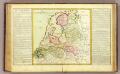
La Hollande.
1 : 1100000 Clouet, J. B. L. (Jean-Baptiste Louis), b. 1730
(Provinces-Unies)
1 : 2900000 Bruyset, Jean-Marie; Schneider, J. H.
XVII Provinciarum Inferioris Germaniae
1 : 1200000 Mollova mapová sbírka Visscher, Nicolaes Fuchs, Jobst Christoph
XVII Provinciarum Inferioris Germaniae
1 : 1200000 Mollova mapová sbírka Visscher, Claes Jansz. Goos, Abraham Visscher, Claes Janszoon
Brabantia V. Rheni Et X. Nova Tabula. [Karte], in: Claud. Ptolemaeus. Geographia lat. cum mappis [...], S. 377.
1 Karte aus Atlas Münster, Sebastian [und Ptolemaeus, Claudius]
Belgii Universi seu Inferioris Germaniae quam XVII Provinciae Aistriaco, Gallico et Batavo Sceptro parentes constituunt nova Tabula Geographica
1 : 1050000 Mollova mapová sbírka Mayer, Tobias Homann, Johann Baptista - dědici
Karte des Rheins von Linz bis zu seinen Mündungen in die Nord und Zuyder See, nebst den Maas von Maastricht bis zu ihrer Mündung
1 : 630000 Linec (Rakousko) Streit, Friedrich Wilhelm Joseph Engelman[n]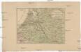
Kriegsschauplatz der Maas und Sambre Armeen
1 : 2780000 Belgie
Souhvězdí naší oblohy
Nizozemsko Studnička, Alois Stumper, Č. Alois Studnička
Köenigreich Niederland nach der letzten Grenz-Berichtigung verfasst
1 : 1200000 Nizozemsko Mollo, Tranquillo Tranquillo Mollo
Köenigreich Niederland nach der letzten Grenz-Berichtigung verfasst
1 : 1200000 Nizozemsko Tranquillo Mollo
[Nizozemsko]
1 : 970000 Belgie
Brabantia V. Rheni Et X. Nova Tabula. [Karte], in: Geographia universalis vetus et nova complectens Claudii Ptolemaei Alexandrini enarrationis libros VIII, S. 326.
1 Karte aus Atlas Münster, Sebastian [und Ptolemaeus, Claudius]
Kaart behoorende bij de statistiek der scheepvaartbeweging in Nederland in 1916
1 : 600000 Annotatie: Op- en afvoer tezamen in 1000-tallen van M3 [S.l. : Topographische Inrichting]
[Kaart], uit: Grande carte routière de la Hollande (Pays-Bas, Nederland) à l'usage des automobiles, cyclistes, touristes, etc. / P. Bineteau, del.
1 : 400000 Bineteau, P. Paris : Taride
Caerte vande Vereenichde Nederlanden
1 : 750000 Mollova mapová sbírka Visscher, Claes Janszoon
Caerte vande VEREENICHDE NEDERlanden
1 : 720000 Belgie Visscher, Claes Jansz. gedruckt by Claes Ianß Visscher inde Calverstraet inde Visscher
Rhein Maas und Schelde oder das Königreich der Niederland von Dinant bis Alkmaar
Stieler's Hand-Atlas Stieler, Adolf bei Justus Perthes
Schetskaart van Nederland
1 : 600000 [S.l. : Topografische Dienst]
Niederlande.
1 : 1200000 Andree, Richard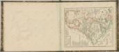

Netherlands.
1 : 1190000 Finley, Anthony
Holland (The Netherlands)
1 : 1200000 Andree, Richard
Das Königreich der Niederlande
1 : 1015000 Lucembursko J. Riedl's Kunsthandlung
Holland.
1 : 1200000 Andree, Richard; Times (London, England)
Regionum Urbium et fluminum quae potissimum Comitatum Mürs ambiunt brevis descriptio. [Karte], in: Gerardi Mercatoris et I. Hondii Newer Atlas, oder, Grosses Weltbuch, Bd. 1, S. 212.
1 Karte aus Atlas Mercator, Gerhard und Hondius, Jodocus Jansson, Jan
Holland, Belgien, Luxemburg.
1 : 1350000 Radefeld, Carl Christian Franz, 1788-1874
Holland, Friesland, Groningen, Overyssel, Gelders, Utrecht and Zealand.
1 : 2471040 Carey, Mathew
The Seven United Provinces of Holland, Groningen, Gelders, Friesland, Overyssel, Utrecht and Zealand.
1 : 2407680 Carey, Mathew


