Maps of Netherlands

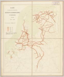
Kaart behoorende bij de statistiek der scheepvaartbeweging in Nederland in 1916
1 : 600000 Annotatie: Op- en afvoer tezamen in 1000-tallen van M3 [S.l. : Topographische Inrichting]
La Hollande.
1 : 1100000 Clouet, J. B. L. (Jean-Baptiste Louis), b. 1730
(Provinces-Unies)
1 : 2900000 Bruyset, Jean-Marie; Schneider, J. H.
Das Königreich der Niederlande
1 : 1015000 Lucembursko J. Riedl's Kunsthandlung
Pays-Bas.
1 : 1000000 Brue, Adrien Hubert, 1786-1832
Carte des XVII. Provinces des Pays Bas
1 : 640000 Mollova mapová sbírka Inselin, Charles Jaillot, Alexis Hubert
Carte routière du Royaume des Pays-Bas, comprenant la Hollande et la Belgique, aux quelles on a joint le grand Duché de Luxembourg : avec l'indication des archevêchés et evêcheés, ainsi que les batailles et les distances d'un lieu à un autre en lieues de poste de 281⁄2 au degré
1 : 650000 par Hérisson, géographe gravé par Berthe. Paris : Basset
Holland and Belgium.
1 : 1110000 Sharpe, J.
Belgium and Holland.
1 : 1500000 Schonberg & Co.

Belgique et Hollande
1 : 1300000 Thuillier, Louis; Hachette. Bibliothèque géographique. Firme Paris : Hachette et cie.
Belgique, Hollande.
1 : 1000000 Lapie, M. (Pierre), 1779-1850
Niederlanden (Holland) und Belgien
Belgie Jelínek, Victor
Niederlande und Belgien
E. von Sydow's Schul-Atlas in sechs und dreissig Karten Sydow, Emil von bei Justus Perthes
Karte der Niederlande
1 : 980000 Belgie C. Hennigs Verlag
Karte der Niederlande
1 : 1000000 Belgie C. Hennig
Pays-Bas, Belgique, Luxembourg.
1 : 1000000 Levasseur, E.
Holland And Belgium.
1 : 1900800 Mitchell, Samuel Augustus
Belgium And Holland.
1 : 1520640 Burr, David H., 1803-1875
Netherlands.
1 : 3350000 Fenner, Rest.
Netherlands, Belgium, Spain, Portugal.
Goodrich, S.G.
Netherlands.
1 : 1480000 Society for the Diffusion of Useful Knowledge (Great Britain)
Belgium And Holland.
1 : 1500000 Greenleaf, Jeremiah
Belgium And Holland.
1 : 1500000 Greenleaf, Jeremiah
Niederlande, Luxemburg.
1 : 1900000 Reichard, C. G.
Niederlande und Belgien
Plastischer Schul-Atlas über alle Theile der Erde : in 24 Karten Woldermann, G Verlag von P. Eckerlein
Niederlande, Belgien und Luxemburg
1 : 600000 Belgie Carl Flemming u. C.T. Wiskott
Holland & Belgium.
1 : 792000 Arrowsmith, John
Königreich Niederland und Königreich Belgien dann das Herzgth. Luxemburg
1 : 1200000 Belgie T. Mollo