Maps of Netherlands

Das Königreich der Niederlande
1 : 1015000 Lucembursko J. Riedl's Kunsthandlung
Království Hollandské (Nizozemsko), Království Belgické
Belgie Hynek Fuchs
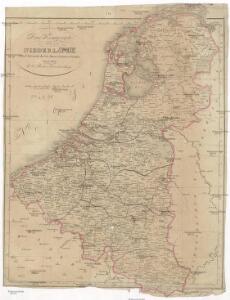
Karte der Niederlande
1 : 980000 Belgie C. Hennigs Verlag
Karte der Niederlande
1 : 1000000 Belgie C. Hennig
Regni di Olanda e del Belgio, e Gran Ducato di Luembourg.
1 : 1010000 Marzolla, Benedetto
Belgique et Hollande
1 : 1300000 Thuillier, Louis; Hachette. Bibliothèque géographique. Firme Paris : Hachette et cie.
Niederlande, Belgien und Luxemburg
1 : 600000 Belgie Carl Flemming u. C.T. Wiskott
Kingdom of the Netherlands, including the Grand duchy of Luxembourg
1 : 740000 Belgie Wyld, James Ja.s Wyld
Belgium, Netherlands, Luxembourg. Pergamon World Atlas.
Polish Army Topography Service
Pays-Bas.
1 : 1000000 Brue, Adrien Hubert, 1786-1832
Holland and Belgium.
1 : 1110000 Sharpe, J.
Norsko, Švédsko, Finsko, Estonsko, Lotyšsko a Litva
1 : 2500000 Belgie Škorpil, František Bohumil Státní nakladatelství

The Kingdom of the Netherlands
1 : 1495000 Belgie Walker, C. Baldwin & Gradock
Belgium, Netherlands, Luxembourg. Pergamon World Atlas.
Polish Army Topography Service
Belgique, Hollande, Limbourg, Luxembourg.
1 : 1000000 Picquet, C.
Kaart behoorende bij de statistiek der scheepvaartbeweging in Nederland in 1916
1 : 600000 Annotatie: Op- en afvoer tezamen in 1000-tallen van M3 [S.l. : Topographische Inrichting]
Netherlands.
1 : 1237000 Teesdale, Henry
Holland, Belgium, and Switzerland.
1 : 1360000 Johnson, A.J.
Belgique et de Hollande, 1812.
1 : 3500000 Malte-Brun, Conrad, 1775-1826
Belgium and Holland.
1 : 1500000 Schonberg & Co.
The Kingdom of the Netherlands
1 : 1500000 engraved by J. & C. Walker. London : Baldwin & Cradock
Pays-Bas et Belgique.
1 : 1180000 Migeon, J.
Holland, Belgium.
1 : 770000 Arrowsmith, John
Nieuwe kaart van het Koningrijk der Nederlanden en het Groot-Hertogdom Luxemburg : met aanwijzing der nieuwe postwegen = Nouvelle carte du Royaume des Pays-Bas et du Grand-Duché de Luxembourg : avec les routes de poste / dressé et gravé par C. van Baarsel et Fils
1 : 580000 Baarsel, C. van La Haye : F.J. Weygand
Carte du Royaume des Pays-Bas.
1 : 1360000 Vivien de St Martin, L.
44. Belgio e Olanda.
1 : 1500000 Touring club italiano
Pays-Bas, Belgique, Luxembourg.
1 : 1000000 Levasseur, E.
Holland and Belgium.
1 : 1300000 Colton, G.W.