Maps of Netherlands

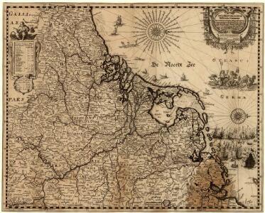
XVII Provinciarum Inferioris Germaniae
1 : 1200000 Mollova mapová sbírka Visscher, Nicolaes Fuchs, Jobst Christoph
XVII Provinciarum Inferioris Germaniae
1 : 1200000 Mollova mapová sbírka Visscher, Claes Jansz. Goos, Abraham Visscher, Claes Janszoon
Artificiosa et geographica tabula sub leonis figura XVII. inferiori Germaniae provincias representans, cui addita sunt singularum insignia, una cum ordinaria praefecturarum distinctione, longe elimatius quam hactenus unquam expressa
1 : 1480000 Belgie Visscher, Claes Jansz. C.I. Visscher
Belgii Veteris Typus
1 : 1400000 Mollova mapová sbírka Ortelius, Abraham Visscher, Claes Jansz.
Belgii Veteris Typus
1 : 1400000 Mollova mapová sbírka Ortelius, Abraham Visscher, Claes Jansz.
Il Corso del Fivme Reno d'Allemagna, dalla Mosella fino al Mare. con tuttu li Dominij che si trouano nelle uicinanze del medesimo Fiume, rappresentati conforme lo stato presente da Giacomo Cantelli da Vignola Geografo del Ser.mo Sig. Dvca di Modena etc. 1689
Mollova mapová sbírka Cantelli, Giacomo Barbey, Antonio De Rossi, Giovanni Giacomo
Belgii Veteris Typvs
1 : 1375000 Mollova mapová sbírka Ortelius, Abraham Ortelius, Abraham
Les Provinces Apellées Pais Bas Connues Sous Les Noms De Flandre Et De Hollande
1 : 600000 Mollova mapová sbírka Fer, Nicolas de Loon, Herman van Fer, Nicolas de
Holland And Belgium.
1 : 2100000 Tanner, Henry S.
Holland And Belgium.
1 : 2050000 Tanner, Henry S.
69. North France, South West Belgium, Netherlands. The World Atlas.
1 : 500000 USSR (Union of Soviet Socialist Republics).
Holland and Belgium.
1 : 2060000 Mitchell, Samuel Augustus
Holland and Belgium.
1 : 2060000 Mitchell, Samuel Augustus
Holland and Belgium.
1 : 2080000 Tanner, Henry S.
Postkarte von dem Vereinigten Niederlanden
Belgie Stenger, Johann im von Reillyschen Landkarten und Kunstwerke Verschleiss Komptoir
Novissima et accuratissima XVII provinciarum Germaniae inferioris tabula
1 : 960000 Belgie Danckerts, Justus Munter, Johan ex officina Iusti Danckers
Descriptio veteris agri Batavi et Frisii omnisque regionis quae hodie est in dicione VII. Foederatorum cis et ultra Rhenum
1 : 950000 auctore Mensone Alting. [Amstelaedami] : [apud Henricum Wetstenium]
Kriegsschauplatz der Maas und Sambre Armeen
1 : 2780000 Belgie

Niederlande und Belgien
Plastischer Schul-Atlas über alle Theile der Erde : in 24 Karten Woldermann, G Verlag von P. Eckerlein
Holand and Belgium.
1 : 1290000 Colton, G.W.
Niederlande, Luxemburg.
1 : 1900000 Reichard, C. G.
Patriae Antique Inter Iuly et Caroli Magni Caesarum Romanorum Tempora Descriptio
1 : 1100000 Mollova mapová sbírka Ewich, Hermann Saevry, S.
Brabantia III. Rheni Et X. Nova Tabula. [Karte], in: Claud. Ptolemaeus. Geographia lat. cum mappis [...], S. 371.
1 Karte aus Atlas Münster, Sebastian [und Ptolemaeus, Claudius]
Belgii universi seu inferioris Germaniae quam XVII. provinciae, Austriaco, Gallico et Batavo sceptro parentes constituunt, nova tabula geographica
1 : 1050000 Belgie Mayer, Tobias Cassini de Thury cura et studio Homannianorum Heredum
Belgii universi seu inferioris Germaniae quam XVII. provinciae, Austriaco, Gallico et Batavo sceptro parentes constituunt, nova tabula geographica
1 : 1050000 Belgie Mayer, Tobias Cassini de Thury cura et studio Homannianorum Heredum
BELGII UNIVERSI seu INFERIORIS GERMANIAE quam XVII PROVINCIAE, Austriaco, Gallico et Batavo Sceptro parentes constituunt, nova Tabula Geographica
1 : 1100000 Belgie Mayer, Tobias Cassini de Thury cura et studio Homannianorum Heredum
Belgii universi seu inferioris Germaniae quam XVII provinciae Austriaco, Gallico et Batavo sceptro parentes constituunt nova tabula geographica
1 : 1050000 Belgie Mayer, Tobias Cassini de Thury cura et studio Homannianorum Heredum
Carte des XVII. Provinces des Pays Bas
1 : 640000 Mollova mapová sbírka Inselin, Charles Jaillot, Alexis Hubert