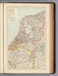
Maps of Netherlands

Niederlande.
1 : 1200000 Andree, Richard
Holland (The Netherlands)
1 : 1200000 Andree, Richard
Holland.
1 : 1200000 Andree, Richard; Times (London, England)
Das Königreich der Niederlande
1 : 1015000 Lucembursko J. Riedl's Kunsthandlung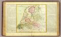
La Hollande.
1 : 1100000 Clouet, J. B. L. (Jean-Baptiste Louis), b. 1730
(Provinces-Unies)
1 : 2900000 Bruyset, Jean-Marie; Schneider, J. H.
Kaart behoorende bij de statistiek der scheepvaartbeweging in Nederland in 1916
1 : 600000 Annotatie: Op- en afvoer tezamen in 1000-tallen van M3 [S.l. : Topographische Inrichting]
Regni di Olanda e del Belgio, e Gran Ducato di Luembourg.
1 : 1010000 Marzolla, Benedetto
Kingdom of the Netherlands, including the Grand duchy of Luxembourg
1 : 740000 Belgie Wyld, James Ja.s Wyld
Grande carte routiere de la Hollande
1 : 400000 Nizozemsko Cartes Taride
Niederlande, Belgien und Luxemburg
1 : 600000 Belgie Carl Flemming u. C.T. Wiskott
[Kaart], uit: Grande carte routière de la Hollande (Pays-Bas, Nederland) à l'usage des automobiles, cyclistes, touristes, etc. / P. Bineteau, del.
1 : 400000 Bineteau, P. Paris : Taride
Norsko, Švédsko, Finsko, Estonsko, Lotyšsko a Litva
1 : 2500000 Belgie Škorpil, František Bohumil Státní nakladatelství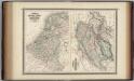
Holland, Belgium, and Switzerland.
1 : 1360000 Johnson, A.J.
Belgium, Netherlands, Luxembourg. Pergamon World Atlas.
Polish Army Topography Service
Království Hollandské (Nizozemsko), Království Belgické
Belgie Hynek Fuchs
[Kaart], uit: Orandakoku zenzu / Senseki Takami
1 : 600000 Annotatie: Facs. van de uitg.: Furukawa : Kakindō, 1850; Lit.: The world in Japanese maps until the mid-19th century, p. 207; Annotatie geografische gegevens: West boven Takami, Senseki [Tokyo : Noma Kakagu Igaku Kenyu Shiryokan]
Belgium, Netherlands, Luxembourg. Pergamon World Atlas.
Polish Army Topography Service
Karte der Niederlande
1 : 980000 Belgie C. Hennigs Verlag
Karte der Niederlande
1 : 1000000 Belgie C. Hennig
Holland and Belgium.
1 : 1300000 Colton, G.W.
Pays-Bas.
1 : 1000000 Brue, Adrien Hubert, 1786-1832
Belgique et Hollande
1 : 1300000 Thuillier, Louis; Hachette. Bibliothèque géographique. Firme Paris : Hachette et cie.
Seven United Provinces.
1 : 510000 Faden, William, 1750?-1836
Holland and Belgium.
1 : 1110000 Sharpe, J.

69. North France, South West Belgium, Netherlands. The World Atlas.
1 : 500000 USSR (Union of Soviet Socialist Republics).
Carte du Royaume des Pays-Bas.
1 : 1360000 Vivien de St Martin, L.
The Kingdom of the Netherlands
1 : 1495000 Belgie Walker, C. Baldwin & Gradock