Maps of Netherlands
[Nizozemsko]
1 : 970000 Belgie
69. North France, South West Belgium, Netherlands. The World Atlas.
1 : 500000 USSR (Union of Soviet Socialist Republics).
Belgii Universi seu Inferioris Germaniae quam XVII Provinciae Aistriaco, Gallico et Batavo Sceptro parentes constituunt nova Tabula Geographica
1 : 1050000 Mollova mapová sbírka Mayer, Tobias Homann, Johann Baptista - dědici
Brabantia III. Rheni Et X. Nova Tabula. [Karte], in: Claud. Ptolemaeus. Geographia lat. cum mappis [...], S. 371.
1 Karte aus Atlas Münster, Sebastian [und Ptolemaeus, Claudius]
La Hollande.
1 : 1100000 Clouet, J. B. L. (Jean-Baptiste Louis), b. 1730
(Provinces-Unies)
1 : 2900000 Bruyset, Jean-Marie; Schneider, J. H.
Totius Fluminis Rheni Novissima Descriptio [Karte, Teil 2], in: Novus atlas absolutissimus, Bd. 2, S. 150.
1 Karte aus Atlas Janssonius Offizin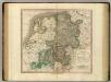
Westphalia.
1 : 1020000 Cary, John, ca. 1754-1835
Artificiosa et geographica tabula sub leonis figura XVII. inferiori Germaniae provincias representans, cui addita sunt singularum insignia, una cum ordinaria praefecturarum distinctione, longe elimatius quam hactenus unquam expressa
1 : 1480000 Belgie Visscher, Claes Jansz. C.I. Visscher
Tabula Geographica qua Pars Septentrionalis sive Inferior Rheni, Mosae et Moselle
1 : 1100000 Mollova mapová sbírka Visscher, Nicolaes Jansz. Visscher, Nicolaus
Tabula Geographica qua Pars Septentrionalis sive Inferior Rheni, Mosae et Moselle
1 : 1100000 Mollova mapová sbírka Visscher, Nicolaes Jansz. Visscher, Nicolaus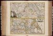
Totius fluminis Rheni : novissima descriptio / ex. officina N. Visscher
1 : 950000 Annotatie: Origineel is Blad 116 in atlas factice; Annotatie geografische gegevens: 2 schaalstokken op kaart met de schaalaanduidingen: Milliaria Germanica com:, Gemeene Duytsche Mylen, en: Milliaria Gallica communia, en: Uren gaans; Zuidwest boven Nicolaes Jansz. Visscher jr. 1649-1702 [Amsterdam : Nicolaes Visscher]
Holand and Belgium.
1 : 1290000 Colton, G.W.
Caerte vande VEREENICHDE NEDERlanden
1 : 720000 Belgie Visscher, Claes Jansz. gedruckt by Claes Ianß Visscher inde Calverstraet inde Visscher
Caerte vande Vereenichde Nederlanden
1 : 750000 Mollova mapová sbírka Visscher, Claes Janszoon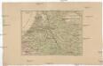
Kriegsschauplatz der Maas und Sambre Armeen
1 : 2780000 Belgie
Niederlanden (Holland) und Belgien
Belgie Jelínek, Victor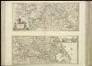
[37][37] Totius fluminis Rheni novissima descriptio, uit: Atlas sive Descriptio terrarum orbis
Annotatie: Gedigitaliseerde versie. Amsterdam. Heiloo : Picturae (vervaardiger), 2015. tiff-bestand. Gedigitaliseerd: 07-01-2015; Origineel: Universiteitsbibliotheek Vrije Universiteit (XL.05127.-) ; Netherlands; Titelpagina ontbreekt Wit, Frederik de Amsterdam : Frederick de Wit
Holland and the other provinces of the United Netherlands.
from New & accurate description of the earth in all its empires, kingdoms and states
Le Cours de la Riviere du Rhein
1 : 1100000 Mollova mapová sbírka Sanson, Guillaume Mortier, Pierre
Accuratissima Rheni inferioris Mosae et Mosellae tabula ac minores in eosdem influentes fluvii
1 : 950000 1 Karte : Kupferdruck ; 49 x 57 cm Danckerts, Theodorus [Danckerts]
Holland and Belgium.
1 : 2060000 Mitchell, Samuel Augustus
Holland and Belgium.
1 : 2060000 Mitchell, Samuel Augustus
Belgii Veteris Typvs
1 : 1375000 Mollova mapová sbírka Ortelius, Abraham Ortelius, Abraham
Königreich Niederland und Königreich Belgien dann das Herzgth. Luxemburg
1 : 1200000 Belgie T. Mollo
Parte inferiore del Rheno con li fivmi a qvello adiacenti
Belgie Boultats
Netherlands, Belgium.
1 : 792000 Stanford, Edward

Spoorwegkaart van het Koningrijk der Nederlanden
1 : 1000000 lith. van L.J. Tordoir. Zwolle : Zeehuisen
Souhvězdí naší oblohy
Nizozemsko Studnička, Alois Stumper, Č. Alois Studnička
Köenigreich Niederland nach der letzten Grenz-Berichtigung verfasst
1 : 1200000 Nizozemsko Mollo, Tranquillo Tranquillo Mollo
![[Nizozemsko]](https://images-2.georeferencer.com/images/iiif/817829810741/full/,300/0/native.jpg)

