Maps of Metropolitan France

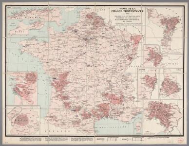
Carte de la France protestante / dressée sous la dir. de la Commission des Publications de la Fédération Protestante de France ; dressée par L. Hermann
1 : 1500000 Hermann, L.; Fédération Protestante de France. Commission des Publications Paris : Fischbacher
A new and exact map of France divided into all its provinces and acquisitions, ...
from The world described, or, A new and correct sett of maps : shewing the kingdoms and states in all the known parts of the earth, with the principal cities, and most considerable towns in the world ... / ... by Herman Moll, geographer ...

Tabula Moderna Gallie [Karte], in: Claudii Ptolemei viri Alexandrini mathematice discipline philosophi doctissimi geographie opus [...], S. 242.
1 Karte aus Atlas Waldseemüller, Martin [und Ptolemaeus, Claudius] Übelin, Georg
Gallia IIII. Nova Tabula [Karte], in: Claud. Ptolemaeus. Geographia lat. cum mappis [...], S. 341.
1 Karte aus Atlas Münster, Sebastian [und Ptolemaeus, Claudius]
La France 843 a 987.
1 : 5800000 Houze, Antoine Philippe
A new and accurate map of France with its aquisitions / composed from the latest surveys assited by the most approved maps & charts & regulated by astrol. Observations by Eman. Bowen
Bowen, Emmanuel
Tercia Europe Tabula [Karte], in: [Clavdii Ptholomei Cosmographi ...], S. 254.
1 Karte aus Atlas Nicolaus Germanus [und Ptolemaeus, Claudius]
France.
1 : 3000000 Lapie, M. (Pierre), 1779-1850
[Frankreich nach dem Friedensschluss von Paris vom 30. Mai 1814, in Départements eingetheilt]
Neuester Schul-Atlas Walch, Johann im Verlag bei Joh. Walch
Gallia IIII. Nova Tabula [Karte], in: Geographia universalis vetus et nova complectens Claudii Ptolemaei Alexandrini enarrationis libros VIII, S. 311.
1 Karte aus Atlas Münster, Sebastian [und Ptolemaeus, Claudius]
France.
1 : 3000000 Andriveau-Goujon, J.
La France
1 Karte : Kupferdruck ; 54 x 77 cm Brion de la Tour; Le Campion; Le Campion chez les Campions freres rue St. Jacques à la ville de Rouen no. 8
Frankreich und Umgebungen von Paris
Hand-Atlas über alle Theile der Erde nach dem neuesten Zustande und über das Weltgebäude Stieler, Adolf bei Justus Perthes
Jak vzniká mapa

Empire Francais et Royaume d'Italie en 1809.
1 : 6000000 Houze, Antoine Philippe
Le Royaume De France, distingué suivant l'estendue de Toutes Ses Provinces Et Ses Acquisitions, dans l'Espagne, dans l'Italie, dans l'Allemagne [...] [Karte], in: Atlas nouveau, contenant toutes les parties du monde [...], Bd. 1, S. 74.
1 Karte aus Atlas Sanson, Nicolas Jaillot, Alexis Hubert und Mortier, Pieter
La France a la mort de Clovis en 510.
1 : 5800000 Houze, Antoine Philippe
La France sous les enfans de Clovis.
1 : 5800000 Houze, Antoine Philippe
Jak vzniká mapa

La France 1643 a 1715.
1 : 6000000 Houze, Antoine Philippe
Frankreich
Allgemeiner Atlas [Walch, Johannes] im Verlag bei Johannes Walch
La France 1350 a 1364.
1 : 6000000 Houze, Antoine Philippe
Carte des Gaules.
1 : 6000000 Malte-Brun, Conrad, 1775-1826
La France 1715 a 1774
1 : 6000000 Houze, Antoine Philippe
Frankreich
Adolf Stieler's Handatlas über alle Theile der Erde und über das Weltgebäude Stieler, Adolf Justus Perthes
Carte pour l'intelligence de l'histoire d'Angleterre
1 Karte : Kupferdruck ; 26 x 26 cm, Bildgrösse 35 x 46 cm Châtelain s.n.
La France 1422 a 1461.
1 : 6000000 Houze, Antoine Philippe