Maps of Metropolitan France
A new and exact map of France divided into all its provinces and acquisitions, ...
from The world described, or, A new and correct sett of maps : shewing the kingdoms and states in all the known parts of the earth, with the principal cities, and most considerable towns in the world ... / ... by Herman Moll, geographer ...
Carte de la France protestante / dressée sous la dir. de la Commission des Publications de la Fédération Protestante de France ; dressée par L. Hermann
1 : 1500000 Hermann, L.; Fédération Protestante de France. Commission des Publications Paris : Fischbacher
Gallia IIII. Nova Tabula [Karte], in: Claud. Ptolemaeus. Geographia lat. cum mappis [...], S. 341.
1 Karte aus Atlas Münster, Sebastian [und Ptolemaeus, Claudius]
Tercia Europe Tabula [Karte], in: [Clavdii Ptholomei Cosmographi ...], S. 254.
1 Karte aus Atlas Nicolaus Germanus [und Ptolemaeus, Claudius]

Jak vzniká mapa

[Ethnographische Karte von Europa]
Zweiter Band, enthaltend in vier Abtheilungen die Vertheilung der Organismen: 5. Pflanzen-Geographie, 6. Thier-Geographie, 7. Anthropographie, 8. Ethnographie Humboldt, Alexander von Verlag von Justus Perthes
Gallia IIII. Nova Tabula [Karte], in: Geographia universalis vetus et nova complectens Claudii Ptolemaei Alexandrini enarrationis libros VIII, S. 311.
1 Karte aus Atlas Münster, Sebastian [und Ptolemaeus, Claudius]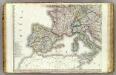
Europe 3.
1 : 3850000 Brue, Adrien Hubert, 1786-1832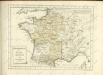

La France 843 a 987.
1 : 5800000 Houze, Antoine Philippe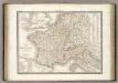
France 1789, 1813.
1 : 3700000 Lapie, M. (Pierre), 1779-1850
[Frankreich nach dem Friedensschluss von Paris vom 30. Mai 1814, in Départements eingetheilt]
Neuester Schul-Atlas Walch, Johann im Verlag bei Joh. Walch
Tabula Moderna Gallie [Karte], in: Claudii Ptolemei viri Alexandrini mathematice discipline philosophi doctissimi geographie opus [...], S. 242.
1 Karte aus Atlas Waldseemüller, Martin [und Ptolemaeus, Claudius] Übelin, Georg
Jak vzniká mapa
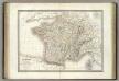
France.
1 : 3000000 Lapie, M. (Pierre), 1779-1850
Frankreich
Allgemeiner Atlas [Walch, Johannes] im Verlag bei Johannes Walch
A new and accurate map of France with its aquisitions / composed from the latest surveys assited by the most approved maps & charts & regulated by astrol. Observations by Eman. Bowen
Bowen, Emmanuel
France, Spain, Portugal, Italy.
1 : 9200000 Mitchell, Samuel Augustus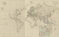
XI. Charte für die allgemeine Geschichte von der Selbstregierung Ludwig XIV. bis auf den österreichischen Erbfolgekrieg : d.i. von 1661 bis 1740 n. Christus
Entworfen von F.W. Benicken A. Falger gr. Weimar : im Verlage des L. Industrie-Comptoirs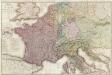
Composite: France.
1 : 1170000 Herisson, Eustache, b. 1759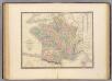
France.
1 : 3000000 Andriveau-Goujon, J.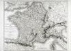
Carte itinéraire de l'empire français et du royaume d'Italie
1 Karte : Kupferdruck ; 56 x 71 cm Tardieu; Chanlaire chez l'auteur rue Geoffroy-Langevin n.o 328 (et 7. n.le ordre)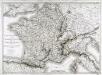
Carte itinéraire de l'empire français et du royaume d'Italie
1 Karte : Kupferdruck ; 56 x 71 cm Tardieu; Chanlaire chez l'auteur rue Geoffroy-Langevin n.o 328 (et 7. n.le ordre)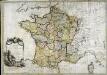
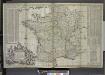
La France
1 Karte : Kupferdruck ; 54 x 77 cm Brion de la Tour; Le Campion; Le Campion chez les Campions freres rue St. Jacques à la ville de Rouen no. 8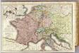
France &c.
1 : 2400000 Brue, Adrien Hubert, 1786-1832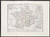
Gallia transalpina
1 : 3300000 Marzolla, Benedetto [Verlag nicht ermittelbar]
Frankreich und Umgebungen von Paris
Hand-Atlas über alle Theile der Erde nach dem neuesten Zustande und über das Weltgebäude Stieler, Adolf bei Justus Perthes
Frankreich
1 Karte : Kupferdruck ; 18 x 22 cm Walch zu finden bey Ioh. Walch


