Maps of Metropolitan France

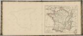
Carte pittoresque et maritime de la France : indiquant la division politique et administrative ... / par A.M. Perrot ; revue et augm. par A. Vuillemin
1 : 1350000 Annotatie: Met aansluitende inzet van Corsica; Met afb. van bezienswaardigheden; Annotatie geografische gegevens: Grenzen en spoorlijnen gekleurd Perrot, A. M.; Vuillemin, A. Paris : Fatout
Frankreich
Grosser Hand-Atlas über alle Theile der Erde in 170 Karten Meyer, J. Verlag des Bibliographischen Instituts
Charte von Frankreich
1 : 900000 Francie Verlage des Kunst und Industrie Compoirs


Frankreich und die Schweiz
Handatlas über alle Theile der Erde und über das Weltgebäude Stieler, Adolf Justus Perthes
Frankreich und die Schweiz
Hand-Atlas über alle Theile der Erde und über das Weltgebäude Stieler, Adolf Justus Perthes

Frankreich und die Schweiz.
1 : 3700000 Berghaus, Hermann
Frankreich
E. von Sydow's Schul-Atlas in sechs und dreissig Karten Sydow, Emil von bei Justus Perthes
Frankreich
Schul-Atlas in 36 Karten Völter, Daniel Verlag der J.M. Dannheimer'schen Buchhandlung
Sprechkarte von Frankreich
Zweiter Band, enthaltend in vier Abtheilungen die Vertheilung der Organismen: 5. Pflanzen-Geographie, 6. Thier-Geographie, 7. Anthropographie, 8. Ethnographie Humboldt, Alexander von Verlag von Justus Perthes
France.
Andriveau-Goujon, J.
Frankreich und Umgebungen von Paris
Stieler's Hand-Atlas Stieler, Adolf bei Justus Perthes
France en Relief.
Vivien St Martin, L.
Frankreich
France Meteorologique.
Jouvet et Cie.
Karte von Frankreich
1 : 4260000 Francie Amon, Anton J. Riedls Kunsthandlung
Karte von Frankreich
1 : 4260000 Francie Amon, Anton J. Riedls Kunsthandlung
La carte nouvelle de la France, ses conquetes, ses acquisitions, et ses bornes, par la paix de Ris-wick
1 : 2500000 corrigée par ordre du Roy et dressée sur les dernieres observations de Mrs. de l'Academie Royale des Sciences, par N. de Fer door Mess.rs van de Koninklyke Wetenschappen op order van de koningh verbetert tot Utrecht : by Caspar Specht
Frankreich 1841
1 : 5290000 Francie Radefeld Stich, Druck und Verlag der geographischen Anstalt des Bibliographischen Instituts
Composite: Frankreich in 4 Blattern.
1 : 1500000 Vogel, C.
Frankreich

Composite: France.
1 : 4400000 Vivien de St Martin, L.
Carte de France divisée en 86 departemens
1 : 2060000
France in Departments.
1 : 2232000 Johnston, W. & A.K.
France, in Departments.
1 : 4500000 Finley, Anthony
France.
Andriveau-Goujon, J.
Nieuwe kaart van Vrankrijk, volgens de nieuwste waarnemingen van de Koningl. Parijsche Academie
1 : 5750000 [S.l.] : [s.n.]