Maps of Metropolitan France
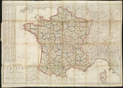
Carte de France divisée en 86 departemens
1 : 2060000
CHARTE von FRANKREICH nach der neuesten Eintheilung in 22. Militair-Divisionen 86. Departemente mit Beziehung auf die alte Eintheilung in Provinzen entworfen
Elba (Itálie)
Charte von Frankreich nach der neuesten Eintheilung in 22. Militair-Divisionen 86. Departemente mit Beziehung auf die alte Eintheilung in Provinzen entworfen
Elba (Itálie)
Frankreich
Hypsometrischer Atlas Ziegler, Jakob Melchior Topogr. Anstalt v. J. Wurster u. Comp.
Frankreich

Charte von Frankreich in Departements eingetheilt
1 : 2500000 Francie Joh. Walch
La France au commencement de la 3eme. race (987-996)
1 : 1
Frankreich
Geographischer Atlas über alle Theile der Erde Ziegler, Jakob Melchior Verlag von Dietrich Reimer
Carte de la France
1 Karte : Kupferdruck ; 55 x 66 cm Poirson; Jean chez Jean M.d d'estampes r. St. Jean de Beauvais n.o 10
La France
1 Karte : Kupferdruck ; 49 x 67 cm Fortin; Robert de Vaugondy; Arrivet chez Fortin ing.r pour les globes et sphères rue de la Harpe près celle du Foin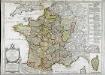
La France
1 Karte : Kupferdruck ; 49 x 67 cm Delamarche; Robert de Vaugondy; Arrivet chez Delamarche géographe rue du Foin St. Jacques au collège de M.e Gervais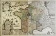
La France
1 Karte auf 2 Blättern : Kupferdruck ; 59 x 92 cm Inselin; Jaillot chez le Sr. Jaillot géographe ordinaire du roy quay et a coté des grands Augustins
Charte von Frankreich
1 : 1650000 Francie Seidel, G. E. F. Cassini, Jean-Dominique Christoph Fembo
Frankreich
[Allgemeiner Atlas über alle Theile der Erde in 29 Blättern] Ziegler, Jakob Melchior Top. Anstalt v. J. Wurster u. Comp.

La France 1350 a 1364.
1 : 6000000 Houze, Antoine Philippe
La France 1814 a 1840.
1 : 6000000 Houze, Antoine Philippe
Carte de France
1 Karte : Kupferdruck ; 54 x 65 cm Klinger J. G. Klinger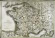
Carte de France
1 Karte : Kupferdruck ; 51 x 77 cm Brion de la Tour; Basset; Basset chez Basset m.d d'estampes rue St. Jacques au coin de celle des Mathurins
La France 1774 a 1793.
1 : 6000000 Houze, Antoine Philippe
La France 1270 a 1328.
1 : 6000000 Houze, Antoine Philippe
La France 1461 a 1483.
1 : 6000000 Houze, Antoine Philippe
Frankreich
Schul-Atlas in 36 Karten Völter, Daniel Verlag der J.M. Dannheimer'schen Buchhandlung
La France 1715 a 1774
1 : 6000000 Houze, Antoine Philippe
La France 1589 a 1643.
1 : 6000000 Houze, Antoine Philippe
La France 1223 a 1270.
1 : 5800000 Houze, Antoine Philippe
La France 1483 a 1547.
1 : 6000000 Houze, Antoine Philippe
La France 1108 a 1180.
1 : 5800000 Houze, Antoine Philippe
La France 1422 a 1461.
1 : 6000000 Houze, Antoine Philippe