Maps of Metropolitan France

France, in Departments.
1 : 4500000 Finley, Anthony
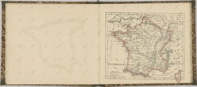
Frankreich
E. von Sydow's Schul-Atlas in sechs und dreissig Karten Sydow, Emil von bei Justus Perthes
France in Departments.
1 : 2232000 Johnston, W. & A.K.
Charte von Frankreich
1 : 900000 Francie Verlage des Kunst und Industrie Compoirs
Tableau d'Assemblage des Six Feuilles de la Carte Géologique de la France
1 : 2000000 Dufrénoy, Ours-Pierre-Armand Petit- ; Elie de Beaumont, Jean Baptiste Armand Louis Léonce ; Brochant de Villiers, André Jean François Marie Ministère des Travaux Publics
France.
1 : 3150000 Teesdale, Henry
Frankreich
Schul-Atlas über alle Theile der Erde nach dem neuesten Zustande, und über das Weltgebäude Stieler, Adolf bei Justus Perthes
Frankreich

Frankreich

Carte pittoresque et maritime de la France : indiquant la division politique et administrative ... / par A.M. Perrot ; revue et augm. par A. Vuillemin
1 : 1350000 Annotatie: Met aansluitende inzet van Corsica; Met afb. van bezienswaardigheden; Annotatie geografische gegevens: Grenzen en spoorlijnen gekleurd Perrot, A. M.; Vuillemin, A. Paris : Fatout
France Politique.
1 : 2500000 Vivien St Martin, L.
Frankreich
Grosser Hand-Atlas über alle Theile der Erde in 170 Karten Meyer, J. Verlag des Bibliographischen Instituts
Frankreich.
1 : 3700000 Berghaus, Heinrich; Flemming, Carl; Sohr, Karl
France Industrie et commerce
Vidal de La Blache, Paul
Frankreich
Schul-Atlas über alle Theile der Erde nach dem neuesten Zustande, und über das Weltgebäude Stieler, Adolf Justus Perthes
Carte itinéraire de la république française
1 Karte : Kupferdruck ; 49 x 53 cm Blondeau; Chanlaire; Bartholomé au depôt de géographie rue Geoffroy-Langevin n.o 328
Carte de la France
1 Karte : Kupferdruck ; 48 x 51 cm Weis chez I. George Treuttel libraire
Frankrijk
1 : 4650000 Den Haag : Kompas
Carte de la France divisée en ses LXXXIII départements
1 : 2580000 Francie par les freres Lotter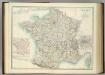
France in Departments.
1 : 2232000 Johnston, Alexander Keith
Frankreich 1841
1 : 5290000 Francie Radefeld Stich, Druck und Verlag der geographischen Anstalt des Bibliographischen Instituts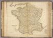
France.
1 : 2300000 Playfair, Principal
Frankreich und die Schweiz
Handatlas über alle Theile der Erde und über das Weltgebäude Stieler, Adolf Justus Perthes
Frankreich und die Schweiz.
1 : 3700000 Berghaus, Hermann
Frankreich und Umgebungen von Paris
Stieler's Hand-Atlas Stieler, Adolf bei Justus Perthes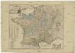
Neue Charte von Frankreich
1 : 2340000 Francie GSF J.B. Klein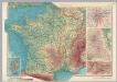
France. Pergamon World Atlas.
1 : 2500000 Polish Army Topography Service
Frankreich und die Schweiz
Hand-Atlas über alle Theile der Erde und über das Weltgebäude Stieler, Adolf Justus Perthes