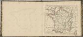
Maps of Metropolitan France

Frankreich
Schul-Atlas über alle Theile der Erde nach dem neuesten Zustande, und über das Weltgebäude Stieler, Adolf bei Justus Perthes
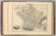
Frankreich
Schul-Atlas über alle Theile der Erde nach dem neuesten Zustande, und über das Weltgebäude Stieler, Adolf Justus Perthes
Frankreich

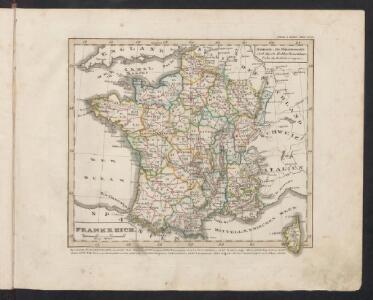
Frankreich
E. von Sydow's Schul-Atlas in sechs und dreissig Karten Sydow, Emil von bei Justus Perthes
Frankreich 1841
1 : 5290000 Francie Radefeld Stich, Druck und Verlag der geographischen Anstalt des Bibliographischen Instituts
France.
Andriveau-Goujon, J.
Frankreich und Umgebungen von Paris
Stieler's Hand-Atlas Stieler, Adolf bei Justus Perthes
France.
Andriveau-Goujon, J.
Frankreich und die Schweiz
Handatlas über alle Theile der Erde und über das Weltgebäude Stieler, Adolf Justus Perthes
Sprechkarte von Frankreich
Zweiter Band, enthaltend in vier Abtheilungen die Vertheilung der Organismen: 5. Pflanzen-Geographie, 6. Thier-Geographie, 7. Anthropographie, 8. Ethnographie Humboldt, Alexander von Verlag von Justus Perthes
France in Departments.
1 : 2232000 Johnston, W. & A.K.
Frankreich und die Schweiz
Hand-Atlas über alle Theile der Erde und über das Weltgebäude Stieler, Adolf Justus Perthes
France.
1 : 4815360 Tallis, J. & F.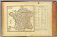
La France, departemens.
1 : 3500000 Bonne, Rigobert, 1727-1794
Carte itinéraire de la république française
1 Karte : Kupferdruck ; 49 x 53 cm Blondeau; Chanlaire; Bartholomé au depôt de géographie rue Geoffroy-Langevin n.o 328
Carte de la France
1 Karte : Kupferdruck ; 48 x 51 cm Weis chez I. George Treuttel libraire
Frankreich

France.
1 : 3000000 Colton, G.W.
Charte von Frankreich
1 : 900000 Francie Verlage des Kunst und Industrie Compoirs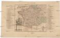
Kriegs Schauplatz zwischen Franckreich u. Ostreich 1792
1 : 2845000 Francie
Frankreich
Volksschul-Atlas über alle Teile der Erde Lange, Henry Druck und Verlag von Georg Westermann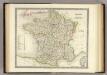
France.
1 : 3150000 Teesdale, Henry
Frankreich.
1 : 3700000 Berghaus, Heinrich; Flemming, Carl; Sohr, Karl
Frankreich und die Schweiz.
1 : 3700000 Berghaus, Hermann
Frontiere du Sud-Est de la France.
1 : 1650000 Jouvet et Cie.
Frankreich
Schul-Atlas in 36 Karten Völter, Daniel Verlag der J.M. Dannheimer'schen Buchhandlung
France Politique.
1 : 2500000 Vivien St Martin, L.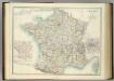
France in Departments.
1 : 2232000 Johnston, Alexander Keith