Maps of Europe

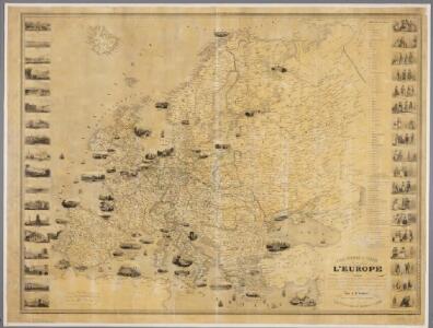
Carte pittoresque & maritime de l'Europe : indiquant la division des Etats, les routes et chemins de fer ... / par A.M. Perrot ; revue et augm. par A. Vuillemin
1 : 5700000 Annotatie: Met afb. van de belangrijkste Europese steden en diverse kostuumfiguren; Annotatie geografische gegevens: Grenzen gekleurd Perrot, A. M.; Vuillemin, A. Paris : Fatout
Europe au Xe Siecle.
1 : 20500000 Monin, C.V.
[Evropa]
1 : 7500000 Evropa
Evropa
1 : 7500000 Evropa Jordán, V. Otto Girgal
Oro-Hydrographische Charte von Europa
Europa Orohydrografie
Neubertova podrobná politická mapa Evropy

Politický přehled Evropy

Europa.
1 : 12000000 Ziegler, J. M.
Europa
Volksschul-Atlas über alle Teile der Erde Lange, Henry Druck und Verlag von Georg Westermann
Europa

Versuch einer Übersicht der geographischen Verbreitung der Gewitter
Erster Band, enthaltend in vier Abtheilungen die Erscheinungen der anorganischen Natur: 1. Meteorologie und Klimatographie. 2. Hydrologie und Hydrographie. 3. Geologie. 4. Tellurischer Magnetismus Humboldt, Alexander von Verlag von Justus Perthes
Europe en 1789.
1 : 12300000 Brue, Adrien Hubert, 1786-1832
[Recto], uit: Europa / [aardrijkskundig medew. G.J. de Vries]
1 : 25000000 titelvariant: Landen van Europa met de hoofdsteden; Annotatie: Titel boven de krt.: Landen van Europa met de hoofdsteden; Verso: register van landen met de hoofdsteden Gerben Johannes de Vries 1886-1968 Sneek : Tonnema & Cie
Evropa

Europa
1 : 10000000 Evropa
Accuratissima Europæ tabula
1 Karte : Kupferdruck ; 48 x 56 cm Danckerts Danckerts
Nova et accurata totius Europæ descriptio
1 Karte : Kupferdruck ; 47 x 56 cm Danckerts Danckerts
Accuratissima Europae tabula
1 : 10000000 1 Karte : Kupferdruck ; 48 x 56 cm Danckerts, Justus [Danckerts]
Europe relief du sol
Vidal de La Blache, Paul
Europa
Plastischer Schul-Atlas über alle Theile der Erde : in 24 Karten Woldermann, G Verlag von P. Eckerlein
Europa
1 : 10000000 entworfen und gezeichnet von C. F. Weiland Weimar : Verlag des Geograph. Instituts
Mittelbach's neueste Reise- Hand- und Kontorkarte von Europa
1 : 5500000 Afrika severní Mittelbach's Verlag
[Geschichtlich-geographischer Atlas von Europa :] VI. Karte von Europa beim Ende der Regierung Otto des Grossen im Jahre 973
entworfen und gezeichnet durch Ferd. Aug. v. Witzleben Gestochen bei K. Kolbe von August Heimburger [Berlin etc.] : [Mittler]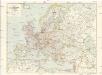
Freytag & Berndts Handkarte von Europa
1 : 6000000 Evropa Freytag & Berndt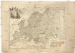
L'Europe
1 : 11930000 Evropa Le Rouge, Georges-Louis Cassini de Thury Le Rouge
Europa
Evropa Weiland, Karl Ferdinand im Verlage des Geograph. Instituts
Europe relief du sol
Vidal de La Blache, Paul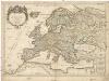
L'Europe
1 : 12000000 Evropa Sanson, Guillaume Cordier, Louis chez H. Iaillot
Eduard Gaeblers Verkehrskarte von Europa
1 : 5000000 Evropa Gaebler, Eduard Eduard Gaeblers Geogr. Inst.