Maps of Europe
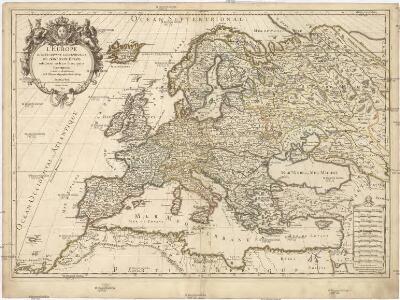
L'Europe
1 : 12000000 Evropa Sanson, Guillaume Cordier, Louis chez H. Iaillot
Europa
Evropa Weiland, Karl Ferdinand im Verlage des Geograph. Instituts
Staatenkarte von Europa
1 : 17500000 Evropa Richter, Emil Adolf Ed. Strache
48. West Europe, Communications. The World Atlas.
1 : 12500000 USSR (Union of Soviet Socialist Republics).
Mapka Europy podług nowych traktatów
1 : 20000000 Evropa "Atlas" Institut Kartograficzny
Freytag & Berndts Handkarte von Europa
1 : 6000000 Evropa Freytag & Berndt
Europae antiquae
1 : 21000000 Evropa in officina Artium
Eclipseos solis totalis cum mora, d. 12 maji 1706 horis antem: in Europa celebratæ, geographica repræsentatio
1 Karte : Kupferdruck ; 46 x 56 cm Schenk; Doppelmayr; Moolen s.n.
Europa
1 : 10000000 Evropa
Europa
1 : 15000000 Evropa Štůla, František Paul Sollors' Nachf.
Europe.
1 : 16500000 Hughes, William
Europa
1 : 10000000 Evropa Weiland, Karl Ferdinand Kratz, W. im Verlage des geograph. Instituts
Europe.
1 : 11000000 Playfair, Principal
Evropa
1 : 7500000 Evropa Jordán, V. Otto Girgal
Politický přehled Evropy
1 : 5000000 Evropa Machát, František V. Neubert
Evropa
1 : 15000000 Evropa Kuchař, Karel Komenium
Eduard Gaeblers Verkehrskarte von Europa
1 : 5000000 Evropa Gaebler, Eduard Eduard Gaeblers Geogr. Inst.
Nova Evropae Descriptio
1 : 9300000 Jansson, Jan Janßonius
Accuratissima Europæ tabula
1 Karte : Kupferdruck ; 48 x 56 cm Danckerts Danckerts
Nova et accurata totius Europæ descriptio
1 Karte : Kupferdruck ; 47 x 56 cm Danckerts Danckerts
Accuratissima Europae tabula
1 : 10000000 1 Karte : Kupferdruck ; 48 x 56 cm Danckerts, Justus [Danckerts]
[Evropa]
1 : 7500000 Evropa
Europa.
1 : 12000000 Ziegler, J. M.
Europa delineata juxta observationes excellorum virorum Academiae Regalis Scientiarum et nonnullor aliorum et juxta recentissimas annotationes
1 : 22200000 Evropa Delisle, Guillaume Lotter, Tobias Conrad Tobiae Conr. Lotter
L'Europe
1 Karte auf 4 Blatt : Kupferdruck ; 97 x 111 cm Robert de Vaugondy; Arrivet; Delamarche chez Delamarche géog. rue du Foin St. Jacques au collège de M.tre Gerrvais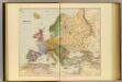
Europe.
1 : 10137600 Stanford, Edward
F. Umlaufta a J.G. Rothauga školní nástěnná mapa Evropy
1 : 3000000 Evropa Umlauft, Friedrich Krejčí, Josef Freytag a Berndt
Europe divided according to the general treaty signed 1.st june 1815 in Congress at Vienna
1 : 9250000 Evropa Wilkinson, Robert Darton, William William Darton
Politický přehled Evropy
1 : 5000000 Evropa Machát, František Tiskem a nákladem uměl. ústavu grafického V. Neuberta na Smíchově