Maps of Europe

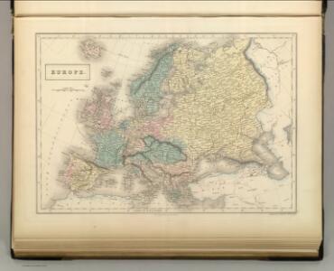
Europe.
1 : 16500000 Hughes, William
Europa
1 : 14000000 Evropa C. Flemming
Europe.
1 : 11000000 Playfair, Principal
Evropa
Evropa Hynek Fuchs
Ewropa
1 : 20600000 Evropa Merklas, Václav V. Merklas
Ewropa
1 : 20600000 Evropa Merklas, Václav V. Merklas
Ewropa
1 : 20600000 Evropa Merklas, Václav V. Merklas
Europa nach dem Weltkriege
1 : 7500000 Evropa Carl Flemming und C. T. Wiskott Aktiengesellschaft für Verlag und Kunstdruck
Politická mapa Evropy
1 : 15000000 Evropa Wolf, R.
Europa
Evropa Weiland, Karl Ferdinand im Verlage des Geograph. Instituts
Europe and the Mediterranean
1 : 6000000 Evropa National Geographic Society
Europe en 1789.
1 : 12300000 Brue, Adrien Hubert, 1786-1832
Politický přehled Evropy
1 : 5000000 Evropa Machát, František V. Neubert
Europe.
1 : 2350000 Finley, Anthony
L'Europe
1 : 11930000 Evropa Le Rouge, Georges-Louis Cassini de Thury Le Rouge
Visecí mapa Evropy
Evropa Kocen, Blaž Kovář, Matěj Radoslav Ed. Helzel
Composite: Europe.
1 : 4800000 Robert Laurie & James Whittle
Europa
Plastischer Schul-Atlas über alle Theile der Erde : in 24 Karten Woldermann, G Verlag von P. Eckerlein
Europa-Karte
1 : 5000000 Evropa Jro-Verlag München Carl Kremling
Europa-Karte
1 : 5000000 Evropa Jro-Verlag Carl Kremling
Europe.
1 : 23000000 Lucas, Fielding Jr.
Europa
1 : 10000000 Evropa

Karte von Europa
1 Karte auf 4 Blatt : Kupferdruck ; 100 x 118 cm Walch zufinden bei J. Walch
Nova et accurate divisa in regna et regiones præcipuas Europæ descriptio
1 Karte : Kupferdruck ; 48 x 57 cm Wit F. de Wit excudit
Accuratissima Europæ tabula
1 Karte : Kupferdruck ; 48 x 56 cm Danckerts Danckerts
Nova et accurata totius Europæ descriptio
1 Karte : Kupferdruck ; 47 x 56 cm Danckerts Danckerts
Accuratissima Europae tabula
1 : 10000000 1 Karte : Kupferdruck ; 48 x 56 cm Danckerts, Justus [Danckerts]
Accuratissima Europæ tabula
1 Karte : Kupferdruck ; 48 x 56 cm Wit; Ottens; Ottens ex officina R. et I. Ottens