Maps of Europe

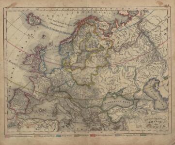
Oro-Hydrographische Charte von Europa
Europa Orohydrografie
Europa
Volksschul-Atlas über alle Teile der Erde Lange, Henry Druck und Verlag von Georg Westermann
[Recto], uit: Europa / [aardrijkskundig medew. G.J. de Vries]
1 : 25000000 titelvariant: Landen van Europa met de hoofdsteden; Annotatie: Titel boven de krt.: Landen van Europa met de hoofdsteden; Verso: register van landen met de hoofdsteden Gerben Johannes de Vries 1886-1968 Sneek : Tonnema & Cie
Europe relief du sol
Vidal de La Blache, Paul
Europe relief du sol
Vidal de La Blache, Paul
Politický přehled Evropy

Versuch einer Übersicht der geographischen Verbreitung der Gewitter
Erster Band, enthaltend in vier Abtheilungen die Erscheinungen der anorganischen Natur: 1. Meteorologie und Klimatographie. 2. Hydrologie und Hydrographie. 3. Geologie. 4. Tellurischer Magnetismus Humboldt, Alexander von Verlag von Justus Perthes
Europa, Fluss- und Gebirgskarte
1 : 24000000 Europa Physische Geografie
Politische Karte von Europa
1 : 20000000 Europa
Europa

Charte von Europa mit der Nordküste von Africa und einen grossen Theile von Asien
1 : 9000000 Afrika severní Marco Berra
Europa-Karte
1 : 5000000 Evropa Jro-Verlag München Carl Kremling
Europa-Karte
1 : 5000000 Evropa Jro-Verlag Carl Kremling
Ewropa
1 : 32000000 Evropa Merklas, Václav
Volksdichte von Europa
1 : 30000000 Europa Bevölkerungsdichte
[Europa]
Evropa
Europa nach dem Weltkriege
1 : 7500000 Evropa Carl Flemming und C. T. Wiskott Aktiengesellschaft für Verlag und Kunstdruck
Politická mapa Evropy
1 : 15000000 Evropa Wolf, R.
Europae [Karte], in: Theatrum orbis terrarum, S. 22.
1 Karte aus Atlas Ortelius, Abraham
Europa
Volksschul-Atlas über alle Teile der Erde Lange, Henry Druck und Verlag von Georg Westermann
Europa
Plastischer Schul-Atlas über alle Theile der Erde : in 24 Karten Woldermann, G Verlag von P. Eckerlein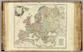
L'Europe divisee en ses principaux Etats.
1 : 9500000 Robert de Vaugondy, Gilles, 1688-1766
Europa.
1 : 12000000 Stein, Christ. Gottfr. Dan.
Evropae
Ortelius, Abraham [Aegidius C. Diesth]
Europa nach seinem politischen Zustande im Jahr 1828
Historisch-genealogisch-geographischer Atlas von Le Sage Las Cases, Emmanuel Auguste Dieudonné Marius Joseph de Johann Velten, Kunsthändler
Composite: Europe.
1 : 4800000 Robert Laurie & James Whittle
Europe.
1 : 2350000 Finley, Anthony
Neue Wandkarte von Europa

Evropa
1 : 6000000 Evropa Melantrich