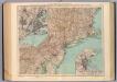
Maps of Massachusetts

Pas caerte van Nieu Nederlandt en de Engelsche Virginies van Cabo Cod tot Cabo Canrick
1 : 9000000 Annotatie: Uit: De zee-atlas, ofte water-weereld ... - Amsterdam : Pieter Goos, 1666 [Amsterdam : Pieter Goos]
Pascaarte van Nieu Nederlandt [Karte], in: De Nieuwe Groote Vermeerderde Zee-Atlas ofte Water-Werelt, S. 67.
1 Karte aus Atlas Doncker, Hendrick
A chart of the sea coasts of New Nederland, Virginia, New England, and Penn-Silvania, with the city of Philadelphia, from Baston to Cabo Carrik
1 : 1600000 Amsterdam : Gerard van Keulen
Pas caert van Nieu Nederland, Virginia en Nieu Engelant
1 Karte : Kupferdruck ; 45 x 54 cm Doncker bÿ Hendrick Doncker boekverkooper en graedbooghmaker inde Nieubrugsteegh in 't Stuurmans gereetschap
A new map of New England, New York, New Iarsey, Pensilvania, Maryland, and Virginia / by Philip Lea in Cheap-side, London.
from Parts
A new map of the most considerable plantations of the English in America / Sutton Nicholls, sculp.; A new sett of maps both of antient and present geography: wherein not only the latitude and longitude of many places are corrected according to the latest observations, but also the most remarkable differences of antient and present geography may be quickly discern'd by a bare inspection or comparing of correspondent maps, which seems to be the most natural and easy method to lead young students (for whose use the work is principally intended) unto a competent knowledge of the geographical science: together with a geographical treatise particularly adapted to the use and design of these maps / by Edward Wells, M.A. and student of Christ-Church, Oxon.
from A new sett of maps both of antient and present geography : wherein not only the latitude and longitude of many places are corrected according to the latest observations, but also the most remarkable differences of antient and present geography may be quickly discern'd by a bare inspection or comparing of correspondent maps, which seems to be the most natural and easy method to lead young students (for whose use the work is principally intended) unto a competent knowledge of the geographical science : together with a geographical treatise particularly adapted to the use and design of these maps / by Edward Wells, M.A. and student of Christ-Church, Oxon. Wells, Edward; Sheldonian Theatre,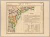
Parties des Etats-Unis. Amer. Sep. 51.
1 : 1641836 Vandermaelen, Philippe, 1795-1869
Novi Belgii novaeque Angliae nec non partis Virginiae tabula
1 : 2220000 Manhattan (New York, New York) Visscher, Nicolaus a Nicolao Joannis Vißchero
A new map of the most considerable plantations of the English in America / Sutton Nicholls, sculp.
from Charts and maps Sutton Nicholls,
A new map of the most considerable plantations of the English in America / Sutton Nicholls, sculp.
from Charts and maps Sutton Nicholls,
Recens edita totius Novi Belgii in America septentrionali siti
1 : 2300000 New York (stát) Seutter, Matthäus Matthäus Seutter
Recens edita totius Novi Belgii in America septentrionali siti, delineatio
1 : 2300000 New York (stát) Seutter, Matthäus sumtibus Matthaei Seutteri
Novi Belgii Novaeque Angliae nec non partis Virginiae tabula
1 : 5500000 Visscher, Nicolaes Burrows Brothers Company
Mappa geographica provinciae novae eboraci ab anglis New-York
1 : 10000 New Jersey Sauthier, Claudii Josephi Homannianor Heredum
A new and accurate map of Virginia & Maryland / laid down from surveys and regulated astronl. observatns. by Eman. Bowen.
from Charts and maps
A map of the provinces of New-York and New Jersey : with a part of Pennsylvania and the Province of Quebec / from the topographical observations of C. J. Sauthier ; engraved and published by Matthew Albert Lotter.
from Charts and maps
Map of the Seat of War: Map showing the railroad routes
Map of the Seat of War: Map showing the railroad routes L. Prang & Co.
Kaart van Nieuw Nederland : behoorende tot de, door het Provinciaal Utrechtsch Genootschap bekroonde Verhandeling van R.G. Bennet en J. van Wyk, Rz.
1 : 1250000 Te Dordrecht : bij J. de Vos & Ci.
Novi Belgii Novaeqve Angliae nec non partis Virginiae Tabula

Recens edita totius Novi Belgii in America Septentrionali siti / delineatio cura et sumtibus Tob. Conr. Lotteri, Sac. Caes. Maj. Geographi August. Vind.
from John H. Levine Collection Conrad Lotter,
A map of the provinces of New-York and New-Jersey, with a part of Pennsylvania and the province of Quebec
1 : 1025000 New Jersey Lotter, Matthäus Albrecht Matthew Albert Lotter
A new map of New Jarsey and Pensilvania / by Robt. Morden.
from Atlas terrestris / by Robt. Morden.
Pas kaart van de zee kusten van Virginia.
from Charts and maps
Kaart van Nieuw Nederland / [getekend door] R. van Wijk
Dordrecht : J. de Vos
Bridge by which the South Mountain & Boston R.R. is to cross the Hudson River at Poughkeepsie, N.Y. ; The Map of South Mountain and Boston
from New illustrated atlas of Dutchess County, New York. / Compiled & drawn from personal examinations, surveys etc. under the personal supervision of O.W. Gray & Son and F.A. Davis, and published under the superintendence of H. L. Kochersperger.
New Jersey.
from Whole
Map of the American Coast, from Lynhaven Bay to Narraganset Bay.
1 : 1267200 Melish, John
Map of the American Coast, from Lynhaven Bay to Narraganset Bay.
1 : 1267200 Melish, John
D'Engelze volkplanting in Virginie / door Iohan Smith bezogt en verder uytgeset ; uytgevoerd te Leyden door Pieter vander Aa.
from De Gedenkwaardige Reizen vanden beroemden Capiteyn Johan Smith na Virginien : gedaan in den Jare 1606. en vervolgens ; waar in een nauwkeurige beschrijving dier Plaatsen, desselfs Inwoonders, hunne Godsdienst, Zeden, Gewoontens, manieren van Regeering, Planten, Vrugten, enz. omstandig vertoond werd, mitsgaders des Schrijvers wonderlijke gevallen met de Wilden, en verdere zeldzame ontmoetingen ; nu aldereerst uit het Engels vertaald, met nodige Konst-printen en Register voorzien.