Maps of New Jersey

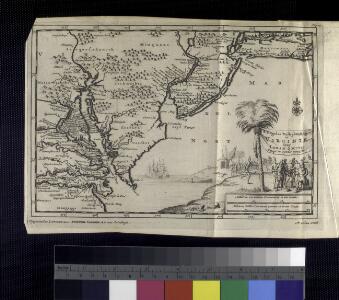
D'Engelze volkplanting in Virginie / door Iohan Smith bezogt en verder uytgeset ; uytgevoerd te Leyden door Pieter vander Aa.
from De Gedenkwaardige Reizen vanden beroemden Capiteyn Johan Smith na Virginien : gedaan in den Jare 1606. en vervolgens ; waar in een nauwkeurige beschrijving dier Plaatsen, desselfs Inwoonders, hunne Godsdienst, Zeden, Gewoontens, manieren van Regeering, Planten, Vrugten, enz. omstandig vertoond werd, mitsgaders des Schrijvers wonderlijke gevallen met de Wilden, en verdere zeldzame ontmoetingen ; nu aldereerst uit het Engels vertaald, met nodige Konst-printen en Register voorzien.
Pas kaart van de zee kusten van Virginia.
from Charts and maps
A new and accurate map of Virginia & Maryland / laid down from surveys and regulated astronl. observatns. by Eman. Bowen.
from Charts and maps
Lord Balitmore's own plan : proposed Maryland/Pennsylvania boundary.
from Maryland
New Jersey.
from Whole
Map of the Seat of War: Map showing the railroad routes
Map of the Seat of War: Map showing the railroad routes L. Prang & Co.
A map of that part of America where a degree of latitude was measured for the Royal Society / by Cha. Mason & Jere. Dixon.
from Charts and maps
Map of Virginia, Maryland and Delaware / I. Mutlow sc. 6 James St. Covt. Gardn.
from Charts and maps
E. United States 7.
1 : 1774080 Letts, Son & Co.
A New map of Virginia.; The history of the British plantations in America. With a chronological account of the most remarkable things, which happen'd to the first adventurers in their several discoveries of that new world. Part I. Containing The history of Virginia; with remarks on the trade and commerce of that colony ...
from The history of the British plantations in America. With a chronological account of the most remarkable things, which happen'd to the first adventurers in their several discoveries of that new world. Part I. Containing The history of Virginia; with remarks on the trade and commerce of that colony ... Keith, William, Sir; Society for the Encouragement of Learning,
A New map of Virginia.
from Cartographic materials from the Emmet Collection of Manuscripts Etc. Relating to American History. Printed at the expense of the Society for the Encouragement of Learning, by S. Richardson: [London],
A new map of New Jarsey and Pensilvania / by Robt. Morden.
from Atlas terrestris / by Robt. Morden.
Il Maryland, il Jersey Meridionale, la Delaware e la parte Orientale della Virginia, e Carolina Settentrionale.
from Charts and maps A. (Antonio) Zatta:[Venezia],
Map of the American Coast, from Lynhaven Bay to Narraganset Bay.
1 : 1267200 Melish, John
Map of the American Coast, from Lynhaven Bay to Narraganset Bay.
1 : 1267200 Melish, John
An exact map of New Jersey, Pensylvania, New York, Maryland & Virginia, from the latest surveys / J. Lodge, sculp.
from Parts John Lodge,
The coast of the United States from New York to St. Augustine (2nd sheet)
1 : 900000 Blunt, Edmund M. (Edmund March), 1770-1862
Colton's Georgetown and the city of Washington : the capital of the United States of America ; Colton's map showing part of Virginia, Maryland, Pennsylvania, New Jersey & New York
1 : 525000 Colton, J. H. Colton, J. H.
A New and accurate map of New Jersey : from the best authorities.
from Whole
Map of Pennsylvania, New Jersey and Delaware compiled from the latest authorities.
from Parts Mitchell, S. Augustus (Samuel Augustus) -- Compiler,
D'Engelze volkplanting in Virginie / door Iohan Smith bezogt en verder uytgeset; uytgevoerd te Leyden door Pieter vander Aa.
from Charts and maps Pieter vander Aa,
North America: sheet VII, Pennsylvania, New Jersey, Maryland, Delaware, Columbia and part of Virginia / published under the superintendence of the Society for the Diffusion of Useful Knowledge; J. & C. Walker, sculp.
from Parts C. Walker,
A new mapp of East and West New Jarsey.
from The sea-atlas : containing an hydrographical description of most of the sea-coasts of the known parts of the world.
A map of New Jersey, from the best authorities.
from The American geography; or, A view of the present situation of the United States of America: containing astronomical geography; geographical definitions, discovery, and general description ... By Jedidiah Morse, A.M.
Nova Virginiae Tabula [Karte], in: Gerardi Mercatoris et I. Hondii Newer Atlas, oder, Grosses Weltbuch, Bd. 2, S. 392.
1 Karte aus Atlas Mercator, Gerhard und Hondius, Jodocus Jansson, Jan
Map of the states of Pennsylvania and New Jersey / engraved & printed by Fenner Sears & Co.
from Parts Fenner Sears & Co.,
Routes between New-York & Washington / drawn by I. Smith, geographer.
from Parts
Virginia / discovered and described by Captayn John Smith, 1606.
from Charts and maps
Penn., N.J., Md., Dela., D.C., Virginia.
1 : 1770000 Society for the Diffusion of Useful Knowledge (Great Britain)