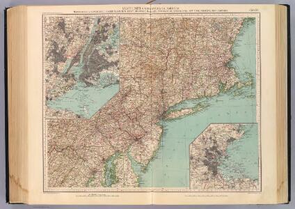
Maps of New York
132-33. Mass., Conn., R.I., N.J., Del., Md.
1 : 1500000 Touring club italiano
(Penn., N.Y., New England) Railroad Map of the United States.
1 : 506880 Rand McNally and Company
Karte von Neu England, Neu Yorck und Pensilvanien

Pensylvania Nova Jersey et Nova York cum Regionibus ad Fluvium Delaware in America sitis
1 : 1000000 Lotter, Tobias Conrad
Map Montreal and Boston Air Line.
1 : 2223700 Montreal and Boston Air Line
A map of the provinces of New-York and New Jersey : with a part of Pennsylvania and the Province of Quebec / from the topographical observations of C. J. Sauthier ; engraved and published by Matthew Albert Lotter.
from Parts
Novi Belgii Novaeque Angliae nec non partis Virginiae tabula
1 : 5500000 Visscher, Nicolaes Burrows Brothers Company
Ohio.
1 : 1830000 Carey, Mathew
State of Ohio.
1 : 1750000 Carey, Mathew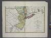
A map of the provinces of New-York and New Jersey : with a part of Pennsylvania and the Province of Quebec / from the topographical observations of C. J. Sauthier ; engraved and published by Matthew Albert Lotter.
from Charts and maps
Massachusetts, Rhode Island, and Connecticut. New York.
1 : 1000000 Schonberg & Co.
The north eastern part of the United States / drawn and engraved by W. Hughes.
from Parts W. Hughes.,
A map of New England and New York

Recens edita totius Novi Belgii in America septentrionali siti
1 : 2300000 New York (stát) Seutter, Matthäus Matthäus Seutter
Recens edita totius Novi Belgii in America septentrionali siti, delineatio
1 : 2300000 New York (stát) Seutter, Matthäus sumtibus Matthaei Seutteri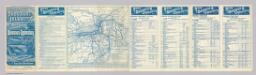
Rome, Watertown & Ogdensburg Railroad.
1 : 4308480 Rome, Watertown & Ogdensburg Railroad Company
A map of the provinces of New-York and New Jersey : with a part of Pennsylvania and the Province of Quebec / from the topographical observations of C. J. Sauthier ; engraved and published by Matthew Albert Lotter.
from Charts and maps
Mappa geographica provinciae novae eboraci ab anglis New-York
1 : 10000 New Jersey Sauthier, Claudii Josephi Homannianor Heredum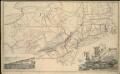
Map of the South Mountain and Boston Railroad & connections showing territory passed through, rail-roads and canals crossed or connected with, together with mineral and geographical features of country passed through
Rome, Watertown and Ogdensburg Railroad.
1 : 5514850 Rome, Watertown & Ogdensburg Railroad Company
Bridge by which the South Mountain & Boston R.R. is to cross the Hudson River at Poughkeepsie, N.Y. ; The Map of South Mountain and Boston
from New illustrated atlas of Dutchess County, New York. / Compiled & drawn from personal examinations, surveys etc. under the personal supervision of O.W. Gray & Son and F.A. Davis, and published under the superintendence of H. L. Kochersperger.
Kaart van Nieuw Nederland / [getekend door] R. van Wijk
Dordrecht : J. de Vos
New York.
1 : 3674880 Scott, Joseph
Northern or Middle States.
1 : 3000000 Cornell, S. S. (Sarah S.)
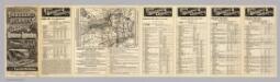
Map of the Seat of War: Map showing the railroad routes
Map of the Seat of War: Map showing the railroad routes L. Prang & Co.
Mappa geographica Provinciae Novae Eboraci ab Anglis New-York dictae / ex ampliori delineatione ad exactas dimensiones concinnata in arctius spatium redacta cura Claudii Josephi Sauthier cui accedit Nova Jersey ex topographicis observationibus.
from Charts and maps Claude Joseph Sauthier,
An exact map of New England, New York, Pensylvania & New Jersey, from the latest surveys / J. Lodge, sculp.
from Parts
The provinces of New York, and New Jersey : with part of Pensilvania and the province of Quebec / drawn by Major Holland, Surveyor General of the Northern District in America ; corrected and improved, from the original materials, by Governr. Pownall, Mem
from Charts and maps
Pennsylvania.
1 : 2175000 Schonberg & Co.
Map of the state of New-York and the surrounding country / by David H. Burr; engd. by Rawdon, Clark & Co., Albany, & Rawdon, Wright & Co., New York.; An atlas of the state of New York: containing a map of the state and of the several counties / by David H. Burr.
from An atlas of the state of New York : containing a map of the state and of the several counties / by David H. Burr. Burr, David H.; Rawdon, Clark & Co.; Rawdon, Wright & Co.; Stone & Clark Republishers,
Map of the state of New-York and the surrounding country / by David H. Burr; engd. by Rawdon, Clark & Co., Albany, & Rawdon, Wright & Co., New York.; An atlas of the state of New York, designed for the use of engineers, containing a map of the state and of the several counties. / Projected and drawn ... under the superintendence and direction of Simeon de Witt.
from An atlas of the state of New York, designed for the use of engineers, containing a map of the state and of the several counties. / Projected and drawn ... under the superintendence and direction of Simeon de Witt. Burr, David H.; De Witt, Simeon; Rawdon, Clark & Co.; Rawdon, Wright & Co.; Stone & Clark Republishers,