Maps of Massachusetts
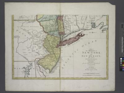
A map of the provinces of New-York and New Jersey : with a part of Pennsylvania and the Province of Quebec / from the topographical observations of C. J. Sauthier ; engraved and published by Matthew Albert Lotter.
from Charts and maps
Novi Belgii Novaeque Angliae nec non partis Virginiae tabula
1 : 5500000 Visscher, Nicolaes Burrows Brothers Company
Pascaarte van Nieu Nederlandt [Karte], in: De Nieuwe Groote Vermeerderde Zee-Atlas ofte Water-Werelt, S. 67.
1 Karte aus Atlas Doncker, Hendrick
Recens edita totius Novi Belgii in America septentrionali siti
1 : 2300000 New York (stát) Seutter, Matthäus Matthäus Seutter
Recens edita totius Novi Belgii in America septentrionali siti, delineatio
1 : 2300000 New York (stát) Seutter, Matthäus sumtibus Matthaei Seutteri
Novi Belgii novaeque Angliae nec non partis Virginiae tabula
1 : 2220000 Manhattan (New York, New York) Visscher, Nicolaus a Nicolao Joannis Vißchero
A chart of the sea coasts of New Nederland, Virginia, New England, and Penn-Silvania, with the city of Philadelphia, from Baston to Cabo Carrik
1 : 1600000 Amsterdam : Gerard van Keulen
Pas caert van Nieu Nederland, Virginia en Nieu Engelant
1 Karte : Kupferdruck ; 45 x 54 cm Doncker bÿ Hendrick Doncker boekverkooper en graedbooghmaker inde Nieubrugsteegh in 't Stuurmans gereetschap
Mappa geographica provinciae novae eboraci ab anglis New-York
1 : 10000 New Jersey Sauthier, Claudii Josephi Homannianor Heredum
132-33. Mass., Conn., R.I., N.J., Del., Md.
1 : 1500000 Touring club italiano
Pas caerte van Nieu Nederlandt en de Engelsche Virginies van Cabo Cod tot Cabo Canrick
1 : 9000000 Annotatie: Uit: De zee-atlas, ofte water-weereld ... - Amsterdam : Pieter Goos, 1666 [Amsterdam : Pieter Goos]
A map of the provinces of New-York and New Jersey : with a part of Pennsylvania and the Province of Quebec / from the topographical observations of C. J. Sauthier ; engraved and published by Matthew Albert Lotter.
from Parts
Kaart van Nieuw Nederland / [getekend door] R. van Wijk
Dordrecht : J. de Vos
Bridge by which the South Mountain & Boston R.R. is to cross the Hudson River at Poughkeepsie, N.Y. ; The Map of South Mountain and Boston
from New illustrated atlas of Dutchess County, New York. / Compiled & drawn from personal examinations, surveys etc. under the personal supervision of O.W. Gray & Son and F.A. Davis, and published under the superintendence of H. L. Kochersperger.
Kaart van Nieuw Nederland : behoorende tot de, door het Provinciaal Utrechtsch Genootschap bekroonde Verhandeling van R.G. Bennet en J. van Wyk, Rz.
1 : 1250000 Te Dordrecht : bij J. de Vos & Ci.
Map of the Seat of War: Map showing the railroad routes
Map of the Seat of War: Map showing the railroad routes L. Prang & Co.
Recens edita totius Novi Belgii in America Septentrionali siti / delineatio cura et sumtibus Tob. Conr. Lotteri, Sac. Caes. Maj. Geographi August. Vind.
from John H. Levine Collection Conrad Lotter,
Novi Belgii Novaeqve Angliae nec non partis Virginiae Tabula

A new map of New Jarsey and Pensilvania / by Robt. Morden.
from Atlas terrestris / by Robt. Morden.
(Penn., N.Y., New England) Railroad Map of the United States.
1 : 506880 Rand McNally and Company
A map of the provinces of New-York and New Jersey : with a part of Pennsylvania and the Province of Quebec / from the topographical observations of C. J. Sauthier ; engraved and published by Matthew Albert Lotter.
from Charts and maps
Map Montreal and Boston Air Line.
1 : 2223700 Montreal and Boston Air Line
Pensylvania Nova Jersey et Nova York cum Regionibus ad Fluvium Delaware in America sitis
1 : 1000000 Lotter, Tobias Conrad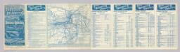
Rome, Watertown & Ogdensburg Railroad.
1 : 4308480 Rome, Watertown & Ogdensburg Railroad Company
Karte von Neu England, Neu Yorck und Pensilvanien

A new and accurate map of Virginia & Maryland / laid down from surveys and regulated astronl. observatns. by Eman. Bowen.
from Charts and maps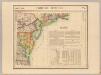
Parties des Etats-Unis. Amer. Sep. 51.
1 : 1641836 Vandermaelen, Philippe, 1795-1869
The north eastern part of the United States / drawn and engraved by W. Hughes.
from Parts W. Hughes.,
A map of the provinces of New-York and New-Jersey, with a part of Pennsylvania and the province of Quebec
1 : 1025000 New Jersey Lotter, Matthäus Albrecht Matthew Albert Lotter