Maps of New York

Maps of New York

$title$

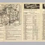
Rome, Watertown and Ogdensburg Railroad.

1 : 5514850 Rome, Watertown & Ogdensburg Railroad Company
$title$

Rome, Watertown & Ogdensburg Railroad.

1 : 4308480 Rome, Watertown & Ogdensburg Railroad Company
$title$

A map of New England and New York

$title$

A map of the provinces of New-York and New Jersey : with a part of Pennsylvania and the Province of Quebec / from the topographical observations of C. J. Sauthier ; engraved and published by Matthew Albert Lotter.

from Parts
$title$

Map Montreal and Boston Air Line.

1 : 2223700 Montreal and Boston Air Line
$title$

A map of the provinces of New-York and New Jersey : with a part of Pennsylvania and the Province of Quebec / from the topographical observations of C. J. Sauthier ; engraved and published by Matthew Albert Lotter.

from Charts and maps
$title$

Lloyd's Railroad, Telegraph & Express Map of the Eastern States

Lloyd's Railroad, Telegraph & Express Map of the Eastern States to accompany Lloyd's Railroad, Telegraph & Express Map of the United States and Canadas. This map shows the communication lines of the eastern states of the Union as they existed in 1863. Reliable communication networks were vital during the war to send troops and messages from one theatre of conflict to another. The map also lists the position of telegraph stations close to the offices of Express companies which provided the main form of travel in this period of American history.
$title$

Map shewing the rail roads between Lake Erie, New York & Boston : intended to illustrate the importance of the N. York & Erie Rail Road / J.F. Smith, del.

from Whole
$title$

Recens edita totius Novi Belgii, in America Septentrionali siti

$title$

Geological Map

from New topographical atlas and gazetteer of New York, comprising a topographical view of the several counties of the state, ... including ... map of the United States and territories ... Compiled from the latest astronomical observations, official surveys and records of the United States and territories ...
$title$

Map of the state of New York with part of Upper Canada / engraved & printed by Fenner Sears & Co.

from Whole
$title$

Mappa geographica Provinciae Novae Eboraci ab Anglis New-York dictae / ex ampliori delineatione ad exactas dimensiones concinnata in arctius spatium redacta cura Claudii Josephi Sauthier cui accedit Nova Jersey ex topographicis observationibus.

from Charts and maps Claude Joseph Sauthier,
$title$

Plan of The State of New York.

from County atlas of Orange, New York / from actual surveys by and under the direction of F.W. Beers.
$title$

Karte von Neu England, Neu Yorck und Pensilvanien

$title$

Carte du theatre de la guerre entre les Anglais et les Américains; dressée d'aprés les cartes anglaises les plus modernes / par M. Brion de la Tour, ingénieur-géographe du roi.

from Revolutionary War, 1775-1783 M. Bellin,
$title$

Plan of The State of New York.

from Atlas of Steuben County, New York : from actual surveys and official records / compiled & published by D.G. Beers & Co.
$title$

Massachusetts, Rhode Island, and Connecticut. New York.

1 : 1000000 Schonberg & Co.
$title$

Novi Belgii Novaeqve Angliae nec non partis Virginiae Tabula

$title$

Mappa geographica provinciae novae eboraci ab anglis New-York

1 : 10000 New Jersey Sauthier, Claudii Josephi Homannianor Heredum
$title$

An exact map of New England, New York, Pensylvania & New Jersey, from the latest surveys / J. Lodge, sculp.

from Parts
$title$

A chorographical map of the province of New-York in North America, divided into counties, manors, patents and townships : exhibiting likewise all the private grants of land made and located in that Province / compiled from actual surveys deposited in the

from Whole
$title$

The provinces of New York, and New Jersey : with part of Pensilvania and the province of Quebec / drawn by Major Holland, Surveyor General of the Northern District in America ; corrected and improved, from the original materials, by Governr. Pownall, Mem

from Charts and maps
$title$

Map of the New York Central & Hudson River and Boston & Albany Railroads

$title$

New York, Vermont, New Hampshire, Rhode Island, Massachusetts & Connecticut.

1 : 1570000 Black, Adam & Charles
$title$

The north eastern part of the United States / drawn and engraved by W. Hughes.

from Parts W. Hughes.,
$title$

New York / by H.S. Tanner ; engraved ... by H.S. Tanner.

from Whole
$title$

Map Central Vt. RR.

1 : 3509000 Central Vermont Railroad Company
$title$

Carte du théatre de la guerre entre les Anglais et les Américains dressée d'après les cartes anglaises les plus modernes, / par M. Brion de la Tour, ingr. géographe du Roi.

from Charts and maps M. Bellin,
$title$

Carte du théatre de la guerre entre les Anglais et les Américains: dressée d'après les cartes anglaises les plus modernes / par M. Brion de la Tour, ingénieur-geógraphe du Roi.

from Charts and maps M. Bellin,
$title$

Map exhibiting the rail road, canal, lake and river routes from New York and Boston to the west, via Ogdensburgh, Buffalo and Sacket's Harbor, N.Y

1 : 1150000 J.H. Bufford & Co J.H. Bufford & Co. Lith.
© MapTiler © OpenStreetMap contributors
How does it work?
These instructions will show you how to find historical maps online.
Getting started
Type the place name in the search box to find the exact location. You can further adjust the search by zooming in and out.
Zoom
Zoom in and out with the buttons or use your mouse or touchpad natively.
Exact Area tool
Click here and draw a rectangle over the map to precisely define the search area.
Set filters
Narrow your search with advanced settings, such as Years (from/to), Fulltext, Publisher, etc.
Results
See the results of your search on the right side. You can scroll down to find more maps of this location.
?

Download OldMapsOnline Mobile