Maps of New Jersey

Pas kaart van de zee kusten van Virginia.
from Charts and maps
D'Engelze volkplanting in Virginie / door Iohan Smith bezogt en verder uytgeset ; uytgevoerd te Leyden door Pieter vander Aa.
from De Gedenkwaardige Reizen vanden beroemden Capiteyn Johan Smith na Virginien : gedaan in den Jare 1606. en vervolgens ; waar in een nauwkeurige beschrijving dier Plaatsen, desselfs Inwoonders, hunne Godsdienst, Zeden, Gewoontens, manieren van Regeering, Planten, Vrugten, enz. omstandig vertoond werd, mitsgaders des Schrijvers wonderlijke gevallen met de Wilden, en verdere zeldzame ontmoetingen ; nu aldereerst uit het Engels vertaald, met nodige Konst-printen en Register voorzien.
A new and accurate map of Virginia & Maryland / laid down from surveys and regulated astronl. observatns. by Eman. Bowen.
from Charts and maps
Pascaarte van Nieu Nederlandt [Karte], in: De Nieuwe Groote Vermeerderde Zee-Atlas ofte Water-Werelt, S. 67.
1 Karte aus Atlas Doncker, Hendrick
Map of the Seat of War: Map showing the railroad routes
Map of the Seat of War: Map showing the railroad routes L. Prang & Co.
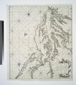
A chart of the sea coasts of New Nederland, Virginia, New England, and Penn-Silvania, with the city of Philadelphia, from Baston to Cabo Carrik
1 : 1600000 Amsterdam : Gerard van Keulen
Pas caerte van Nieu Nederlandt en de Engelsche Virginies van Cabo Cod tot Cabo Canrick
1 : 9000000 Annotatie: Uit: De zee-atlas, ofte water-weereld ... - Amsterdam : Pieter Goos, 1666 [Amsterdam : Pieter Goos]
Lord Balitmore's own plan : proposed Maryland/Pennsylvania boundary.
from Maryland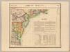
Parties des Etats-Unis. Amer. Sep. 51.
1 : 1641836 Vandermaelen, Philippe, 1795-1869
Map of the American Coast, from Lynhaven Bay to Narraganset Bay.
1 : 1267200 Melish, John
Map of the American Coast, from Lynhaven Bay to Narraganset Bay.
1 : 1267200 Melish, John
New Jersey.
from Whole
A map of that part of America where a degree of latitude was measured for the Royal Society / by Cha. Mason & Jere. Dixon.
from Charts and maps
Map of Virginia, Maryland and Delaware / I. Mutlow sc. 6 James St. Covt. Gardn.
from Charts and maps
An exact map of New Jersey, Pensylvania, New York, Maryland & Virginia, from the latest surveys / J. Lodge, sculp.
from Parts John Lodge,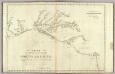
The coast of the United States from New York to St. Augustine (2nd sheet)
1 : 900000 Blunt, Edmund M. (Edmund March), 1770-1862
A new map of New Jarsey and Pensilvania / by Robt. Morden.
from Atlas terrestris / by Robt. Morden.
A New map of Virginia.; The history of the British plantations in America. With a chronological account of the most remarkable things, which happen'd to the first adventurers in their several discoveries of that new world. Part I. Containing The history of Virginia; with remarks on the trade and commerce of that colony ...
from The history of the British plantations in America. With a chronological account of the most remarkable things, which happen'd to the first adventurers in their several discoveries of that new world. Part I. Containing The history of Virginia; with remarks on the trade and commerce of that colony ... Keith, William, Sir; Society for the Encouragement of Learning,
A New map of Virginia.
from Cartographic materials from the Emmet Collection of Manuscripts Etc. Relating to American History. Printed at the expense of the Society for the Encouragement of Learning, by S. Richardson: [London],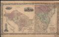
Colton's Georgetown and the city of Washington : the capital of the United States of America ; Colton's map showing part of Virginia, Maryland, Pennsylvania, New Jersey & New York
1 : 525000 Colton, J. H. Colton, J. H.
E. United States 7.
1 : 1774080 Letts, Son & Co.
Il Maryland, il Jersey Meridionale, la Delaware e la parte Orientale della Virginia, e Carolina Settentrionale.
from Charts and maps A. (Antonio) Zatta:[Venezia],
D'Engelze volkplanting in Virginie / door Iohan Smith bezogt en verder uytgeset; uytgevoerd te Leyden door Pieter vander Aa.
from Charts and maps Pieter vander Aa,
Carte de la Baye et Riviere de Délaware, contenant une éxacte et entiére description des rivages, criques, havres, sondes, bas-sonds, sables et gissements des marques ...
1 : 31000 France. Dépôt des cartes et plans de la marine France. Dépôt des cartes et plans de la marine
A New and accurate map of New Jersey : from the best authorities.
from Whole
Nova Virginiae Tabula [Karte], in: Gerardi Mercatoris et I. Hondii Newer Atlas, oder, Grosses Weltbuch, Bd. 2, S. 392.
1 Karte aus Atlas Mercator, Gerhard und Hondius, Jodocus Jansson, Jan
North America: sheet VII, Pennsylvania, New Jersey, Maryland, Delaware, Columbia and part of Virginia / published under the superintendence of the Society for the Diffusion of Useful Knowledge; J. & C. Walker, sculp.
from Parts C. Walker,
Routes between New-York & Washington / drawn by I. Smith, geographer.
from Parts
Americae pars, nunc Virginia dicta : primum ab Anglis inuenta, sumtibus Dn. Walteri Raleigh, Equestris ordinis Viri, Anno Dni. MDLXXXV regni Vero Sereniss. nostrae Reginae Elisabethae XXVII, hujus vero Historia peculiari Libro descripta est, additis etia
from John H. Levine Collection