Maps of New Jersey

New Jersey.
from Whole
A new and accurate map of Virginia & Maryland / laid down from surveys and regulated astronl. observatns. by Eman. Bowen.
from Charts and maps
D'Engelze volkplanting in Virginie / door Iohan Smith bezogt en verder uytgeset ; uytgevoerd te Leyden door Pieter vander Aa.
from De Gedenkwaardige Reizen vanden beroemden Capiteyn Johan Smith na Virginien : gedaan in den Jare 1606. en vervolgens ; waar in een nauwkeurige beschrijving dier Plaatsen, desselfs Inwoonders, hunne Godsdienst, Zeden, Gewoontens, manieren van Regeering, Planten, Vrugten, enz. omstandig vertoond werd, mitsgaders des Schrijvers wonderlijke gevallen met de Wilden, en verdere zeldzame ontmoetingen ; nu aldereerst uit het Engels vertaald, met nodige Konst-printen en Register voorzien.
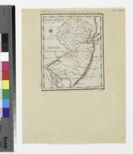
A New and accurate map of New Jersey : from the best authorities.
from Whole
A map of New Jersey, from the best authorities.
from The American geography; or, A view of the present situation of the United States of America: containing astronomical geography; geographical definitions, discovery, and general description ... By Jedidiah Morse, A.M.
Map of the American Coast, from Lynhaven Bay to Narraganset Bay.
1 : 1267200 Melish, John
Map of the American Coast, from Lynhaven Bay to Narraganset Bay.
1 : 1267200 Melish, John
A map of that part of America where a degree of latitude was measured for the Royal Society / by Cha. Mason & Jere. Dixon.
from Charts and maps
An exact map of New Jersey, Pensylvania, New York, Maryland & Virginia, from the latest surveys / J. Lodge, sculp.
from Parts John Lodge,
D'Engelze volkplanting in Virginie / door Iohan Smith bezogt en verder uytgeset; uytgevoerd te Leyden door Pieter vander Aa.
from Charts and maps Pieter vander Aa,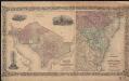
Colton's Georgetown and the city of Washington : the capital of the United States of America ; Colton's map showing part of Virginia, Maryland, Pennsylvania, New Jersey & New York
1 : 525000 Colton, J. H. Colton, J. H.
A new mapp of East and West New Jarsey.
from The sea-atlas : containing an hydrographical description of most of the sea-coasts of the known parts of the world.
Index to the Plates in Christopher Colles' Survey of the Roads.
1 : 2027520 Ristow, W. editor
Map of Pennsylvania, New Jersey and Delaware compiled from the latest authorities.
from Parts Mitchell, S. Augustus (Samuel Augustus) -- Compiler,
North America: sheet VII, Pennsylvania, New Jersey, Maryland, Delaware, Columbia and part of Virginia / published under the superintendence of the Society for the Diffusion of Useful Knowledge; J. & C. Walker, sculp.
from Parts C. Walker,
The provinces of New York, and New Jersey : with part of Pensilvania, and the governments of Trois Rivieres, and Montreal / drawn by Capt. Holland ; engraved by Thomas Jefferys, geographer to His Majesty.
from Parts
Map of the states of Pennsylvania and New Jersey / engraved & printed by Fenner Sears & Co.
from Parts Fenner Sears & Co.,
Routes between New-York & Washington / drawn by I. Smith, geographer.
from Parts
New Jersey.
from Supplement to the New York observer.
Carte de la Baye et Riviere de Délaware, contenant une éxacte et entiére description des rivages, criques, havres, sondes, bas-sonds, sables et gissements des marques ...
1 : 31000 France. Dépôt des cartes et plans de la marine France. Dépôt des cartes et plans de la marine
New Jersey
1 : 505000 Sotzmann, D. F Bey Carl Ernst Bohn
New Iarsey / by John Seller.
from A new system of geography : designed in a most plain and easie method, for the better understanding that science : accommodated with new maps of all the empires, kingdoms, principalities, dukedoms, provinces, and countries in the whole world : with geographical tables, explaining the divisions in each map / by John Seller, late hydrographer to the King.
A chart of Delaware Bay and River : containing a full and exact description of the shores, creeks, harbours, soundings, shoals, sands, and bearings of the most considerable land marks &c. &c. / faithfully coppied [sic] from that published at Philadelphia
from Parts
The Province of New Jersey, divided into East and West, commonly called the Jerseys / engraved & published by Wm. Faden.
from Charts and maps
The Province of New Jersey, divided into East and West, commonly called the Jerseys / engraved & published by Wm. Faden, Charing Cross, December 1st, 1777 ; Croisey, sculpt.
from Whole
Map of the state of Maryland : laid down from an actual survey of all the principal waters, public roads, and divisions of the counties therein : describing the situation of the cities, towns, villages, houses of worship and other public buildings, fu...
From Maryland
The State of New Jersey / compiled from the most accurate surveys / Martin sculpt.
from Whole
Virginia & Maryland.
1 : 1150000 Bowen, Emanuel
New Jersey / engraved by J.H. Young.
from Whole