Maps of Pennsylvania

A new map of New Jarsey and Pensilvania / by Robt. Morden.
from Atlas terrestris / by Robt. Morden.
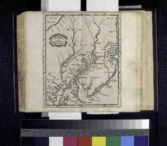
Novi Belgii novaeque Angliae nec non partis Virginiae tabula
1 : 2220000 Manhattan (New York, New York) Visscher, Nicolaus a Nicolao Joannis Vißchero
County map of Pennsylvania, New Jersey, Maryland and Delaware ; City of Philadelphia [inset]; City of Baltimore [inset].
from Mitchell's new general atlas, containing maps of the various countries of the world, plans of cities, etc., embraced in fifty-three quarto maps., forming a series of eighty four maps and plans, together with valuable statistical tables.
A new and accurate map of Virginia & Maryland / laid down from surveys and regulated astronl. observatns. by Eman. Bowen.
from Charts and maps
A map of the provinces of New-York and New Jersey : with a part of Pennsylvania and the Province of Quebec / from the topographical observations of C. J. Sauthier ; engraved and published by Matthew Albert Lotter.
from Charts and maps
Map of the Seat of War: Map showing the railroad routes
Map of the Seat of War: Map showing the railroad routes L. Prang & Co.
Delineatio Pennsilvaniae et Caesareae, nov. occident seu West N. Iersey in America / Jonas Silfvorling sculp. Up. 1731.
from Dissertatio gradualis, de plantatione ecclesiae svecanae in America : quam, suffragante ampl. senatu philosoph. in Regio Upsal. athenaeo, praeside, viro amplissimo atque celeberrimo mag. Andrea Bronwall ... in audit. Gust. maj. d. 14 jun. an. MDCCXXXI / examinandam modeste sistit Tobias E. Biörck, americano-dalekarlus.
Novi Belgii Novaeque Angliae nec non partis Virginiae tabula
1 : 5500000 Visscher, Nicolaes Burrows Brothers Company
Lord Balitmore's own plan : proposed Maryland/Pennsylvania boundary.
from Maryland
Pas caert van Nieu Nederland, Virginia en Nieu Engelant
1 Karte : Kupferdruck ; 45 x 54 cm Doncker bÿ Hendrick Doncker boekverkooper en graedbooghmaker inde Nieubrugsteegh in 't Stuurmans gereetschap
Map of the American Coast, from Lynhaven Bay to Narraganset Bay.
1 : 1267200 Melish, John
Map of the American Coast, from Lynhaven Bay to Narraganset Bay.
1 : 1267200 Melish, John
Middle States.
1 : 3600000 Huntington, Nathaniel G. (Nathaniel Gilbert), 1785-1848
E. United States 7.
1 : 1774080 Letts, Son & Co.
A chart of the sea coasts of New Nederland, Virginia, New England, and Penn-Silvania, with the city of Philadelphia, from Baston to Cabo Carrik
1 : 1600000 Amsterdam : Gerard van Keulen
Schonberg's Map of Pennsylvania, New Jersey, Maryland and Delaware.
1 : 1900000 Schonberg & Co.
Pennsylvania.
1 : 2175000 Schonberg & Co.
A map of the canals & rail roads of Pennsylvania and New Jersey, and the adjoining states / by H.S. Tanner; engraved by H.S. Tanner & assistants.
from Parts Henry S. Tanner,
Pas caerte van Nieu Nederlandt en de Engelsche Virginies van Cabo Cod tot Cabo Canrick
1 : 9000000 Annotatie: Uit: De zee-atlas, ofte water-weereld ... - Amsterdam : Pieter Goos, 1666 [Amsterdam : Pieter Goos]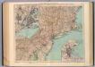
132-33. Mass., Conn., R.I., N.J., Del., Md.
1 : 1500000 Touring club italiano
Penn., N.J., Md., Dela., D.C., Virginia.
1 : 1770000 Society for the Diffusion of Useful Knowledge (Great Britain)
Northern or Middle States.
1 : 3000000 Cornell, S. S. (Sarah S.)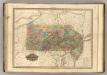
Pennsylvania and New Jersey.
1 : 1120000 Tanner, Henry S.
A map of the canals & rail roads of Pennsylvania and New Jersey, and the adjoining states / by H.S. Tanner; engraved by H.S. Tanner & assistants.
from Parts Henry S. Tanner,
A map of the canals & rail roads of Pennsylvania and New Jersey and the adjoining states / by H. S. Tanner; engraved by H.S. Tanner & assistants.
from Parts Henry S. Tanner,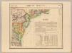
Parties des Etats-Unis. Amer. Sep. 51.
1 : 1641836 Vandermaelen, Philippe, 1795-1869
A map of the provinces of New-York and New-Jersey, with a part of Pennsylvania and the province of Quebec
1 : 1025000 New Jersey Lotter, Matthäus Albrecht Matthew Albert Lotter
Pennsylvania.
1 : 2724480 Scott, Joseph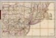
(Penn., N.Y., New England) Railroad Map of the United States.
1 : 506880 Rand McNally and Company