Maps of Germany

Deutschland
Geographischer Atlas über alle Theile der Erde Ziegler, Jakob Melchior Verlag von Dietrich Reimer
Deutschland
Geographischer Atlas über alle Theile der Erde Ziegler, Jakob Melchior Verlag von Joh. Wurster um Comp.
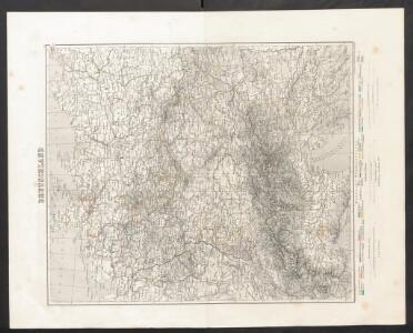
Deutschland.
1 : 2400000 Ziegler, J. M.
Oro-hydrographische Charte von Deutschland und der Schweiz : insbesondere zur Uebersicht der grossen topographisch-militairischen Charten von Deutschland in 217 und von der Schweiz in 24 Blättern
1 : 3000000 entworfen von C.F. Weiland Weimar : im Verlage des Geograph. Instituts

Oro-hydrographische Charte von Deutschland und der Schweiz
1 : 2890000 Evropa střední Weiland, Karl Ferdinand
Dějiště války třicetileté po míru vestfálském

Germany.
1 : 2429000 Johnson, A.J.
[Neuer Atlas der ganzen Erde nach den neuesten Bestimmungen ... : XIV.] Gebirgs- und Gewaesser-Charte von Teutschland, oder der Teutsche Staaten-Bund
Entworfen und gezeichnet von Dr. F.W. Streit H. Leutemann sc. Leipzig : J.C. Hinrichs'sche Buchhandlung

Norddeutsche Bundesstaaten, Süddeutsche Bundesstaaten
Evropa střední
Deutschland.
1 : 3400000 Radefeld, Carl Christian Franz, 1788-1874
Societas Jesu Germana sive Assistentia Germaniae
1 : 2420000 Evropa střední Hartzheim, Fran.
Deutschland.
1 : 2300000 Weiland, C. F. (Carl Ferdinand), d. 1847
Germany, Switzerland, N. Italy.
1 : 5300000 Mitchell, Samuel Augustus
Deutschland
1 : 2350000 Evropa střední Weiland, Karl Ferdinand Geographisches Institut
Deutschland
1 : 2350000 Evropa střední Weiland, Karl Ferdinand Geographisches Institut
Deutschland
1 : 2350000 Evropa střední Weiland, Karl Ferdinand Geographisches Institut
Karte von Deutschland
Grosser Hand-Atlas über alle Theile der Erde in 170 Karten Meyer, J. Verlag des Bibliographischen Instituts
Deutschland, Niederlande, Belgien, Schweiz.
1 : 10000000 Brudin, J. L.; Stieler, Adolf
Neuste Post Karte von Deutschland und dessen angrenzenden Laender
Evropa střední Walch, Johann bey Ioh. Walch
Neueste Karte von Deutschland, der Schweiz und Ober-Italien in 4 Blättern
1 : 1700000 Ravenstein, Ludwig Bibliographisches Institut
Tableau l'historie de la Confederation Germanique.
1 : 6200000 Duval, Henri
Reichskreise 1792
Deutschland Reichskreis Kunz, Andreas ; Moeschl, Joachim Robert
Carte de l'Empire d'Alemagne
1 : 2900000 Mollova mapová sbírka Duval, Pierre Duval, Pierre
Germany.
1 : 3170000 Mitchell, Samuel Augustus
Germany.
1 : 3170000 Mitchell, Samuel Augustus
Reichskreise 1648
Deutschland Reichskreis Kunz, Andreas ; Moeschl, Joachim Robert
Reichskreise 1555
Deutschland Kunz, Andreas ; Moeschl, Joachim Robert