Maps of Germany

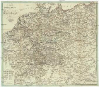
Neuste Post Karte von Deutschland und dessen angrenzenden Laender
Evropa střední Walch, Johann bey Ioh. Walch
Deutschland.
1 : 3400000 Radefeld, Carl Christian Franz, 1788-1874
Nova totius Germaniae descriptio
1 : 3640000 Evropa střední Hofmann, Johann Johann Hofman[n]
Germania magna ausser der Cimbrischen Halbinsel
Německo Kruse, Friedrich Leidenfrost, E. in Ernst Kleins literarischem und geographishem Comptoir
Deutschland.
1 : 4800000 Reichard, C. G.
Germany.
1 : 9000000 Fenner, Rest.
Deutschland.
1 : 2400000 Ziegler, J. M.
Norddeutsche Bundesstaaten, Süddeutsche Bundesstaaten
Evropa střední
Germania Antiqua in IV. Magnos Populos, in Minores Populos, et in Minimos, distincta. Illyricum Occidentis cum Itineribus Romanis
1 : 2900000 Mollova mapová sbírka Sanson, Nicolas Robert de Vaugondy, Gilles
Carte de l'Empire d'Alemagne
1 : 2900000 Mollova mapová sbírka Duval, Pierre Duval, Pierre
Deutschland und anliegende Länder, zur Übersicht der Eisenbahnen und Hauptstrassen
Hand-Atlas über alle Theile der Erde nach dem neuesten Zustande und über das Weltgebäude Stieler, Adolf bei Justus Perthes
Tableau l'historie de la Confederation Germanique.
1 : 6200000 Duval, Henri
Carte generale di lutta l Alemagna, e paesi circonuicini
Evropa střední
Confederation Germanique.
1 : 4000000 Malte-Brun, Conrad, 1775-1826
Neue und vollstaendige Postkarte durch ganz Deutschland und durch die angränzenden Theile der benachbarten Länder
1 : 1465000 Evropa střední Thurn-Taxis, Karel Anselm von denen Homaennischen Erben
Neue und vollstaendige Postkarte durch ganz Deutschland und durch die angränzenden Theile der benachbarten Länder
1 : 1465000 Evropa střední Thurn-Taxis, Karel Anselm von denen Homaennischen Erben
Neue und vollständige Postkarte durch ganz Deutschland und durch die angränzende Theile der benachbarten Länder
1 : 1465000 Evropa střední Heger, Franz Joseph Emmerich Joseph von denen Homaennischen Erben
Deutschland und anliegende Länder, zur Übersicht der Hauptstrassen und Entfernungen
Hand-Atlas über alle Theile der Erde nach dem neuesten Zustande und über das Weltgebäude Stieler, Adolf bei Justus Perthes
Deutschland
1 : 2350000 Evropa střední Weiland, Karl Ferdinand Geographisches Institut
Deutschland
1 : 2350000 Evropa střední Weiland, Karl Ferdinand Geographisches Institut
Deutschland
1 : 2350000 Evropa střední Weiland, Karl Ferdinand Geographisches Institut
Charte das Deutsche Reich nach seinen Kreisen und deren Unterabtheilungen vorstellend
1 : 2660000 Francie Güssefeld, Franz L. von den Homännischen Erben
Charte das Deutsche Reich nach seinen Kreisen und deren Unterabtheilungen vorstellend
1 : 2660000 Evropa střední Güssefeld, Franz L. von den Homännischen Erben
Kharte von Deutschland nach der neuesten Eintheilung, zufolge der Bestimmung des Wiener Congresses und des Pariser Frieden von 1815 entworfen
1 : 2300000 Augsburg : bei Joh. Walch
Reise Karte von Deutschland
Evropa střední Julius, E. Vieweg, Friedrich Friedrich Vieweg
Societas Iesu Germana Sive Assistentia Germaniae
1 : 2600000 Mollova mapová sbírka Seutter, Matthäus Seutter, Georg Matthäus Seutter, Matthäus
Imperium Romano-Germanicum in suos circulos electorat. et status
1 : 5100000 Evropa střední Seutter, Matthäus Lotter, Tobias Conrad apud Matth. Seutter
Deutschland's Eisenbahnen und Strassen-Netz mit seinen Anschlüssen im Ausland nebst Angabe der wichtigsten Flussdampfschiff-Stationen und Häfen für Seedampfer
1 : 2080000 Evropa střední Gräf, Adolf Hensgen, C. Geographisches Institut
Deutschland nach seinen oro-hydrographischen Verhältnissen
1 : 2570000 Evropa střední Gräf, Adolf Eyb, O. B. Geographisches Institut