Maps of Netherlands

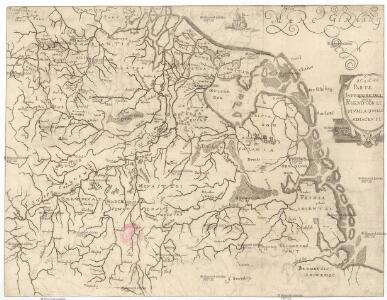
Parte inferiore del Rheno con li fivmi a qvello adiacenti
Belgie Boultats
69. North France, South West Belgium, Netherlands. The World Atlas.
1 : 500000 USSR (Union of Soviet Socialist Republics).
Holland und Berg
Allgemeiner Atlas [Walch, Johannes] im Verlag bei Johannes Walch
Spoorwegkaart van het Koningrijk der Nederlanden
1 : 1000000 lith. van L.J. Tordoir. Zwolle : Zeehuisen
Descriptio veteris agri Batavi et Frisii omnisque regionis quae hodie est in dicione VII. Foederatorum cis et ultra Rhenum
1 : 950000 auctore Mensone Alting. [Amstelaedami] : [apud Henricum Wetstenium]
Holland and the other provinces of the United Netherlands.
from New & accurate description of the earth in all its empires, kingdoms and states
Holland and Belgium.
1 : 2060000 Mitchell, Samuel Augustus
Holland and Belgium.
1 : 2060000 Mitchell, Samuel Augustus
Charte über die saemtlichen zum Westphaelischen Kreis gehörige Laender
1 : 834000 Vestfálsko (Německo) Güssefeld, Franz L. Homaenischen Erben
Holand and Belgium.
1 : 1290000 Colton, G.W.
[37][37] Totius fluminis Rheni novissima descriptio, uit: Atlas sive Descriptio terrarum orbis
Annotatie: Gedigitaliseerde versie. Amsterdam. Heiloo : Picturae (vervaardiger), 2015. tiff-bestand. Gedigitaliseerd: 07-01-2015; Origineel: Universiteitsbibliotheek Vrije Universiteit (XL.05127.-) ; Netherlands; Titelpagina ontbreekt Wit, Frederik de Amsterdam : Frederick de Wit
La Hollande.
1 : 1100000 Clouet, J. B. L. (Jean-Baptiste Louis), b. 1730
(Provinces-Unies)
1 : 2900000 Bruyset, Jean-Marie; Schneider, J. H.
Holland or the United Provinces.
from A new systeme of the mathematicks: containing I. Arithmetick, as well natural and decimal, as in species, or the principles of algebra. II. Practical geometry, together with the first six books of Euclid's Elements, as also the eleventh and twelfth, symbo
Artificiosa et geographica tabula sub leonis figura XVII. inferiori Germaniae provincias representans, cui addita sunt singularum insignia, una cum ordinaria praefecturarum distinctione, longe elimatius quam hactenus unquam expressa
1 : 1480000 Belgie Visscher, Claes Jansz. C.I. Visscher
[Nizozemsko]
1 : 970000 Belgie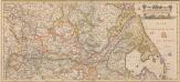
Totius Fluminis Rheni Novissima Descriptio [Karte, Teil 2], in: Novus atlas absolutissimus, Bd. 2, S. 150.
1 Karte aus Atlas Janssonius Offizin
Totius fluminis Rheni : novissima descriptio / ex. officina N. Visscher
1 : 950000 Annotatie: Origineel is Blad 116 in atlas factice; Annotatie geografische gegevens: 2 schaalstokken op kaart met de schaalaanduidingen: Milliaria Germanica com:, Gemeene Duytsche Mylen, en: Milliaria Gallica communia, en: Uren gaans; Zuidwest boven Nicolaes Jansz. Visscher jr. 1649-1702 [Amsterdam : Nicolaes Visscher]
A new and exact map of the United Provinces, or Netherlands &c.
from The world described, or, A new and correct sett of maps : shewing the kingdoms and states in all the known parts of the earth, with the principal cities, and most considerable towns in the world ... / ... by Herman Moll, geographer ...
Westphalia.
1 : 2000000 Bowen, Frances
Karte von Holland nach der letzten Gränz-Berichtigung verfasst
1 : 970000 Nizozemsko Tranq. Mollo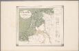
25. Nederland : de dijken weggedacht ..., uit: Geologische kaart van Nederland / door W.C.H. Staring ; bew. aan de Topographische Inrichting
1 : 200000 Winand Carel Hugo Staring 1808-1877; Topographische Inrichting, 's-Gravenhage 's-Gravenhage : Belinfante
Holland.
1 : 1300000 Darton, William
Charte über die sæmtlichen zum Westphælischen Kreis gehörige Lænder
1 Karte : Kupferdruck ; 52 x 47 cm Güssefeld bey den Homænnischen Erben
Caerte vande VEREENICHDE NEDERlanden
1 : 720000 Belgie Visscher, Claes Jansz. gedruckt by Claes Ianß Visscher inde Calverstraet inde Visscher
Caerte vande Vereenichde Nederlanden
1 : 750000 Mollova mapová sbírka Visscher, Claes Janszoon
Niederland u. Belgien.
1 : 1000000 Ziegler, J. M.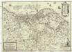
Nova et accurata XVII. Germaniae inferioris provinciarum delineatio et repraesentatio
1 : 860000 Nizozemsko I. H. S. Hipschmann, Sigmund Gabriel Johann Hofmann
Schetskaart van Nederland
1 : 600000 [S.l. : Topografische Dienst]