Maps of Netherlands

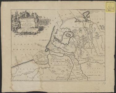
Descriptio veteris agri Batavi et Frisii omnisque regionis quae hodie est in dicione VII. Foederatorum cis et ultra Rhenum
1 : 950000 auctore Mensone Alting. [Amstelaedami] : [apud Henricum Wetstenium]
Belgii Veteris Typus
1 : 1400000 Mollova mapová sbírka Ortelius, Abraham Visscher, Claes Jansz.
Belgii Veteris Typus
1 : 1400000 Mollova mapová sbírka Ortelius, Abraham Visscher, Claes Jansz.
Holland or the United Provinces.
from A new systeme of the mathematicks: containing I. Arithmetick, as well natural and decimal, as in species, or the principles of algebra. II. Practical geometry, together with the first six books of Euclid's Elements, as also the eleventh and twelfth, symbo
Postkarte von dem Vereinigten Niederlanden
Belgie Stenger, Johann im von Reillyschen Landkarten und Kunstwerke Verschleiss Komptoir
Niederlande, Luxemburg.
1 : 1900000 Reichard, C. G.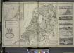
A new and exact map of the United Provinces, or Netherlands &c.
from The world described, or, A new and correct sett of maps : shewing the kingdoms and states in all the known parts of the earth, with the principal cities, and most considerable towns in the world ... / ... by Herman Moll, geographer ...
Postarum seu Veredariorum Stationes Per Germaniam et Provincias Adiacentes.
1 : 400000 Mollova mapová sbírka Danckerts, Justus Danckerts, Cornelis
69. North France, South West Belgium, Netherlands. The World Atlas.
1 : 500000 USSR (Union of Soviet Socialist Republics).
NOVUS XVII | INFERIORIS GERMANIÆ | PROVINCIARUM TYPUS
de integro multis in locis emendatus à Guliel. Ianßonio. Josua | vanden Ende sculp. Ghedruckt | t'Amsterdam, | bij Willem Ianszoon op 't Water | inde vergulde Zonnewyser
Novus XVII Inferioris Germaniae Provinciarum Typus [Karte], in: Le théâtre du monde, ou, Nouvel atlas contenant les chartes et descriptions de tous les païs de la terre, Bd. 1, S. 329.
1 Karte aus Atlas Blaeu, Willem Janszoon und Blaeu, Joan Blaeu, Willem Janszoon
Neue und richtige Landtafel der XVII Niderländische Provincien : abbildende alle befestigte, bemauerte, offene Stedte und Schantzen, etc.
1 : 1260000 Annotatie geografische gegevens: Noordwest boven Nürnberg : Jacob Sandrart
Novus XVII Inferioris Germaniae Provinciarum Typus [...] [Karte], in: Novus Atlas, das ist, Weltbeschreibung, Bd. 1, S. 298.
1 Karte aus Atlas Blaeu, Joan Blaeu, Willem Janszoon
Nova Totius Belgii Sive Germaniae Inferioris accuratissima Delineatio. [Karte], in: Novus atlas absolutissimus, Bd. 3, S. 11.
1 Karte aus Atlas Janssonius Offizin
NOVUS XVII | INFERIORIS GERMANIÆ | PROVINCIARUM TYPUS
de integro multis in locis emendatus à Guliel. Ianßonio. Josua | vanden Ende sculp. Ghedruckt | t'Amsterdam, | bij Willem Ianszoon op 't Water | inde vergulde Zonnewyser
Belgii sive Germaniae Inferioris accuratissima tabula. [Karte], in: Gerardi Mercatoris et I. Hondii Newer Atlas, oder, Grosses Weltbuch, Bd. 1, S. 368.
1 Karte aus Atlas Mercator, Gerhard und Hondius, Jodocus Jansson, Jan
Novus XVII Inferioris Germaniae Procinviarum Typus [Karte], in: Theatrum orbis terrarum, sive, Atlas novus, Bd. 1, S. 323.
1 Karte aus Atlas Blaeu, Joan Blaeu, Willem Janszoon
Carte des XVII. Provinces des Pays Bas
1 : 640000 Mollova mapová sbírka Inselin, Charles Jaillot, Alexis Hubert
Holland and Belgium.
1 : 2060000 Mitchell, Samuel Augustus
Holland and Belgium.
1 : 2060000 Mitchell, Samuel Augustus
Niederland u. Belgien
1 : 2220000 Belgie Stein, Carl
Charte über die saemtlichen zum Westphaelischen Kreis gehörige Laender
1 : 840000 Evropa severozápadní Güssefeld, Franz L. bey den Homaennischen Erben
Inferioris Germaniae provinciarum nova descriptio / [Willem Jansz. Blaeu]
1 : 900000 Annotatie: Onder de titel een nadere omschrijving in het Latijn en Nederlands; Aan het oorspronkelijke kaartbeeld zijn het Bourtangerveen en Fort Bourtange toegevoegd; Lit.: Monumenta cartografica Neerlandica, IV, p. 31-32, 146-153, facs. 5; Oorspr. uitg.: 1604 Blaeu, Willem Jansz. Amstelodami : ex officina Guilielmi Johannis
Artificiosa et geographica tabula sub leonis figura XVII. inferiori Germaniae provincias representans, cui addita sunt singularum insignia, una cum ordinaria praefecturarum distinctione, longe elimatius quam hactenus unquam expressa
1 : 1480000 Belgie Visscher, Claes Jansz. C.I. Visscher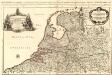
Provinces-Unies des Pays-Bas
1 : 625000 Mollova mapová sbírka Sanson, Guillaume Jaillot, Alexis Hubert
S. North Sea ports.
1 : 1500000 Philip, George
Niederland u. Belgien.
1 : 1000000 Ziegler, J. M.
Niederlande und Belgien
Adolf Stieler's Handatlas über alle Theile der Erde und über das Weltgebäude Stieler, Adolf Justus Perthes
Novissima et accuratissima XVII provinciarum Germaniae inferioris tabula
1 : 960000 Belgie Danckerts, Justus Munter, Johan ex officina Iusti Danckers