Maps of Netherlands

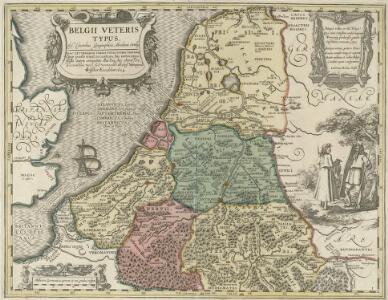
Belgii Veteris Typus
1 : 1400000 Mollova mapová sbírka Ortelius, Abraham Visscher, Claes Jansz.
Belgii Veteris Typus
1 : 1400000 Mollova mapová sbírka Ortelius, Abraham Visscher, Claes Jansz.
Niederland u. Belgien
1 : 2220000 Belgie Stein, Carl
Postkarte von dem Vereinigten Niederlanden
Belgie Stenger, Johann im von Reillyschen Landkarten und Kunstwerke Verschleiss Komptoir
Neue und richtige Landtafel der XVII Niderländische Provincien : abbildende alle befestigte, bemauerte, offene Stedte und Schantzen, etc.
1 : 1260000 Annotatie geografische gegevens: Noordwest boven Nürnberg : Jacob Sandrart
Les dix-sept provinces des Pays-Bas
1 : 1240000 Belgie Sanson, Guillaume Cordier, Louis chez H. Iaillot
A new and exact map of the United Provinces, or Netherlands &c.
from The world described, or, A new and correct sett of maps : shewing the kingdoms and states in all the known parts of the earth, with the principal cities, and most considerable towns in the world ... / ... by Herman Moll, geographer ...
Pas-caert van Texel tot aen de Hoofden
1 Karte : Kupferdruck ; 43 x 53 cm Doncker bÿ Hendrick Doncker boekverkoper en graadbooghmaker in de Nieubrugsteegh in 't Stuurmans gereetschap
Belgii Veteris [Karte], in: Novus atlas absolutissimus, Bd. 3, S. 8.
1 Karte aus Atlas Janssonius Offizin
Nova Totius Belgii Sive Germaniae Inferioris accuratissima Delineatio. [Karte], in: Novus atlas absolutissimus, Bd. 3, S. 11.
1 Karte aus Atlas Janssonius Offizin
Belgii Veteris Typus [...] [Karte], in: Gerardi Mercatoris et I. Hondii Newer Atlas, oder, Grosses Weltbuch, Bd. 1, S. 361.
1 Karte aus Atlas Mercator, Gerhard und Hondius, Jodocus Jansson, Jan
[Königreich der Niederlande]
Neuester Schul-Atlas Walch, Johann im Verlag bei Joh. Walch
Belgii Veteris Typus. [Karte], in: Theatrum orbis terrarum, S. 470.
1 Karte aus Atlas Ortelius, Abraham Vrients, Jan Baptista
Descriptio veteris agri Batavi et Frisii omnisque regionis quae hodie est in dicione VII. Foederatorum cis et ultra Rhenum
1 : 950000 auctore Mensone Alting. [Amstelaedami] : [apud Henricum Wetstenium]
Novus XVII Inferioris Germaniae Provinciarum Typus [...] [Karte], in: Novus Atlas, das ist, Weltbeschreibung, Bd. 1, S. 298.
1 Karte aus Atlas Blaeu, Joan Blaeu, Willem Janszoon
Artificiosa et geographica tabula sub leonis figura XVII. inferiori Germaniae provincias representans, cui addita sunt singularum insignia, una cum ordinaria praefecturarum distinctione, longe elimatius quam hactenus unquam expressa
1 : 1480000 Belgie Visscher, Claes Jansz. C.I. Visscher
Novus XVII Inferioris Germaniae Provinciarum Typus [Karte], in: Le théâtre du monde, ou, Nouvel atlas contenant les chartes et descriptions de tous les païs de la terre, Bd. 1, S. 329.
1 Karte aus Atlas Blaeu, Willem Janszoon und Blaeu, Joan Blaeu, Willem Janszoon
Charte über die saemtlichen zum Westphaelischen Kreis gehörige Laender
1 : 840000 Evropa severozápadní Güssefeld, Franz L. bey den Homaennischen Erben
Belgii sive Germaniae Inferioris accuratissima tabula. [Karte], in: Gerardi Mercatoris et I. Hondii Newer Atlas, oder, Grosses Weltbuch, Bd. 1, S. 368.
1 Karte aus Atlas Mercator, Gerhard und Hondius, Jodocus Jansson, Jan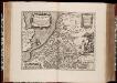
Belgii veteris typus : ex conatibus geographicis Abrahami Ortelij
1 : 1400000 Annotatie: Gegraveerd door Pieter van den Keere; De kaart geeft de Nederlanden weer in de tijd van de Romeinen; Origineel is Blad 33 in atlas factice; Kopie van de kaart van Abraham Ortelius uit 1584; Annotatie geografische gegevens: Met schaalstok Pieter van den Keere 1571-ná 1646; Abraham Ortelius 1527-1598 [Amsterdam : C.J. Visscher excudebat]
NOVUS XVII | INFERIORIS GERMANIÆ | PROVINCIARUM TYPUS
de integro multis in locis emendatus à Guliel. Ianßonio. Josua | vanden Ende sculp. Ghedruckt | t'Amsterdam, | bij Willem Ianszoon op 't Water | inde vergulde Zonnewyser
Leo Belgicus / Johan van Doetechum fecit
1 : 350000 Annotatie: Facs. van de uitg.: [Amsterdam] : C.J. Visscher excudit, 1650. - Het betreft de 3e staat van de kaart van J. van Doetechum uit 1598, bijgewerkt door C.J. Visscher; Uitg. t.g.v. de tentoonstelling "De wereld op papier", in het Amsterdams Historisch Museum, april 1967 Joannes van Doetecum de Oudere -1605; Visscher, Claes Jansz. [S.l. : s.n.]
NOVUS XVII | INFERIORIS GERMANIÆ | PROVINCIARUM TYPUS
de integro multis in locis emendatus à Guliel. Ianßonio. Josua | vanden Ende sculp. Ghedruckt | t'Amsterdam, | bij Willem Ianszoon op 't Water | inde vergulde Zonnewyser
Naauwkeurige kaart van het oude Nederland en eenige aangrenzende gewesten.
1 : 2000000 Isaak Tirion. Te Amsterdam : by Isaak Tirion
Novus XVII Inferioris Germaniae Procinviarum Typus [Karte], in: Theatrum orbis terrarum, sive, Atlas novus, Bd. 1, S. 323.
1 Karte aus Atlas Blaeu, Joan Blaeu, Willem Janszoon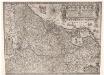
Inferioris Germaniae provinciarum nova descriptio / [Willem Jansz. Blaeu]
1 : 900000 Annotatie: Onder de titel een nadere omschrijving in het Latijn en Nederlands; Aan het oorspronkelijke kaartbeeld zijn het Bourtangerveen en Fort Bourtange toegevoegd; Lit.: Monumenta cartografica Neerlandica, IV, p. 31-32, 146-153, facs. 5; Oorspr. uitg.: 1604 Blaeu, Willem Jansz. Amstelodami : ex officina Guilielmi Johannis
69. North France, South West Belgium, Netherlands. The World Atlas.
1 : 500000 USSR (Union of Soviet Socialist Republics).
Holland or the United Provinces.
from A new systeme of the mathematicks: containing I. Arithmetick, as well natural and decimal, as in species, or the principles of algebra. II. Practical geometry, together with the first six books of Euclid's Elements, as also the eleventh and twelfth, symbo
Holland And Belgium.
1 : 2100000 Tanner, Henry S.