Maps of Netherlands
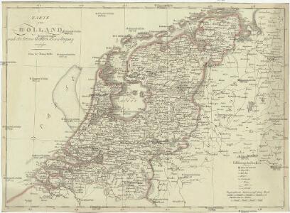
Karte von Holland nach der letzten Gränz-Berichtigung verfasst
1 : 970000 Nizozemsko Tranq. Mollo
Nova et accurata XVII. Germaniae inferioris provinciarum delineatio et repraesentatio
1 : 860000 Nizozemsko I. H. S. Hipschmann, Sigmund Gabriel Johann Hofmann
Foederatum Belgium Nec non Ducatus Bremensis ac etiam Pars Fluminis Albis Peraccurate correcta auctore
1 : 840000 Mollova mapová sbírka Allard, Carel
La Hollande
1 : 650000 W.C. v. Baarsel del. et sculp. [S.l.] : J. R. Poster excudit
Carte de la république de France, 8
1 Blatt : 35 x 59 cm s.n.
The seat of war in the circle of Westphalia
1 : 2543400
Holland.
1 : 1300000 Darton, William
Parte inferiore del Rheno con li fivmi a qvello adiacenti
Belgie Boultats
Summaria Descriptio Fresiae Vniversae; cum latissimè patuit nomen Post emigrationem Francorvm; Saxonvmq; accessionem
1 : 1400000 Mollova mapová sbírka Alting, Menso Broen, Gerrit de
Oud Nederland zo als het zelve door de Batavieren, Marezaaten, Sturien, Frisiabonen ... en andere volkeren oudtijds bewoond wierd, naar de plaatsing der beste schrijveren.
1 : 3500000 Te Amsterdam : bij Arend Fokke Simonsz.
25. Nederland : de dijken weggedacht ..., uit: Geologische kaart van Nederland / door W.C.H. Staring ; bew. aan de Topographische Inrichting
1 : 200000 Winand Carel Hugo Staring 1808-1877; Topographische Inrichting, 's-Gravenhage 's-Gravenhage : Belinfante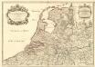
Provinces-Unies des Pays-Bas avec leurs Acquisitions dans la Flandre, le Brabant, le Limbourg et le Lyege
1 : 770000 Mollova mapová sbírka Sanson, Guillaume Cordier, Louis Jaillot, Alexis Hubert
Nouvelle carte des departements de Hollande et des départemens circonvoisins de l'Empire Francais = Nieuwe kaart der departementen van Holland, en die der omliggende van het Fransche keizerrijk
1 : 760000 W.C. van Baarsel del. et sc. A Amsterdam : chez E. Maaskamp
Holland.
1 : 1300000 Lucas, Fielding Jr.
Nieuwe aardrykskundige kaart van het Koningryk Holland in deszelfs geheel grondgebied met het voormalig Oost-Friesland, Jeverland, Kniphuisen en Varel
1 : 700000 naar de jongste Staats-verdragen door Jacob de Gelder A Zürcher sculp. Te Amsterdam : by Johs. Allart en Jacs. Ruis
Spoorwegkaart van het Koningrijk der Nederlanden
1 : 1000000 lith. van L.J. Tordoir. Zwolle : Zeehuisen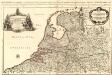
Provinces-Unies des Pays-Bas
1 : 625000 Mollova mapová sbírka Sanson, Guillaume Jaillot, Alexis Hubert
Holland.
1 : 1457280 Lucas, Fielding Jr.
Charte des Königreichs Holland
1 : 650000 Nizozemsko Stieler, Adolf Streit, Friedrich Wilhelm
Charte des Königreichs Holland
1 : 650000 Nizozemsko Stieler, Adolf Streit, Friedrich Wilhelm
Charte des Königreichs Holland
1 : 650000 Nizozemsko Stieler, Adolf Streit, Friedrich Wilhelm
CHARTE des KÖNIGREICHS HOLLAND
1 : 640000 Nizozemsko Stieler, Adolf Streit, Friedrich Wilhelm
Charte des Königreichs Holland
1 : 650000 Nizozemsko Stieler, Adolf Streit, Friedrich Wilhelm
Charte des Königreichs Holland
1 : 650000 Nizozemsko Stieler, Adolf Streit, Friedrich Wilhelm
5me [Driehoeksnet], uit: Nouvelle carte de la Hollande, d'après Kraijenhoff et les meilleures cartes connues / Établissement Géographique de Bruxelles, fondé par Ph. Vander Maelen
1 : 117000 Annotatie: De bladen zijn genummerd 1-24. De bladen 2 t/m 24 hebben elk een afzonderlijke titel. Blad 5 bevat: Triangulations et positions. Blad 9 bevat: Plan d'Amsterdam; De kaartbladen 1, 5, 9 en 24 zijn niet ingekleurd; Van kaartblad 24 is een extra (ingekleurd) exempl. aanwezig; Annotatie geografische gegevens: 2 schaalstokken: 5 Echelle de 5 lieues de 20 au degré ... (= 23,2 cm) en 7380 Echelle de 5 lieues de 20 au degré ... (= 23,2 cm); Legenda; Met indexkaart: Carte d'assemblage Philippe Marie Guillaume Vander Maelen 1795-1869; Établissement Géographique de Bruxelles Bruxelles : Établissement Géographique
Charte über die saemtlichen zum Westphaelischen Kreis gehörige Laender
1 : 834000 Vestfálsko (Německo) Güssefeld, Franz L. Homaenischen Erben
Descriptio Frisiae sub Francorum reditum qua hodie VII Foederator. est
1 : 950000 auctore Mensone Alting Ger. de Broen fec. Amstel. [Amstelaedami] : [apud Henricum Wetstenium]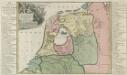
Descriptio Frisiae sub Francorum reditum qua hodie VII Foederator est
1 : 550000 Mollova mapová sbírka Alting, Menso
Provinces unies des Pays-Bas avec leurs acquisitions dans la Flandre, le Brabant, le Limbourg, et le Lyege et les places qu'elles tiennent sur le Rhin dans le Duché de Cleves, et dans l'Archevesché et Eslectorat de Cologne
1 : 700000 par G. Valck. À Amsterdam : chez G. Valck
Charte der Hollaendischen départemens
Nizozemsko Kipferling, Karl Joseph Krayenhoff, Cornelius Rudolphus Theodorus J. Riedl's Kunsthandung