Maps of Netherlands

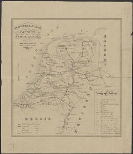
Spoorwegkaart van het Koningrijk der Nederlanden
1 : 1000000 lith. van L.J. Tordoir. Zwolle : Zeehuisen
Niederland u. Belgien.
1 : 1000000 Ziegler, J. M.
25. Nederland : de dijken weggedacht ..., uit: Geologische kaart van Nederland / door W.C.H. Staring ; bew. aan de Topographische Inrichting
1 : 200000 Winand Carel Hugo Staring 1808-1877; Topographische Inrichting, 's-Gravenhage 's-Gravenhage : Belinfante
Parte inferiore del Rheno con li fivmi a qvello adiacenti
Belgie Boultats
Holland.
1 : 1300000 Darton, William
La Hollande.
1 : 1100000 Clouet, J. B. L. (Jean-Baptiste Louis), b. 1730
(Provinces-Unies)
1 : 2900000 Bruyset, Jean-Marie; Schneider, J. H.
Descriptio veteris agri Batavi et Frisii omnisque regionis quae hodie est in dicione VII. Foederatorum cis et ultra Rhenum
1 : 950000 auctore Mensone Alting. [Amstelaedami] : [apud Henricum Wetstenium]
69. North France, South West Belgium, Netherlands. The World Atlas.
1 : 500000 USSR (Union of Soviet Socialist Republics).
Caerte vande VEREENICHDE NEDERlanden
1 : 720000 Belgie Visscher, Claes Jansz. gedruckt by Claes Ianß Visscher inde Calverstraet inde Visscher
Caerte vande Vereenichde Nederlanden
1 : 750000 Mollova mapová sbírka Visscher, Claes Janszoon
Holland und Berg
Allgemeiner Atlas [Walch, Johannes] im Verlag bei Johannes Walch
Nouvelle carte des departements de Hollande et des départemens circonvoisins de l'Empire Francais = Nieuwe kaart der departementen van Holland, en die der omliggende van het Fransche keizerrijk
1 : 760000 W.C. van Baarsel del. et sc. A Amsterdam : chez E. Maaskamp
Schetskaart van Nederland
1 : 600000 [S.l. : Topografische Dienst]
Holland.
1 : 1457280 Lucas, Fielding Jr.
Provinces unies des Pays-Bas avec leurs acquisitions dans la Flandre, le Brabant, le Limbourg, et le Lyege et les places qu'elles tiennent sur le Rhin dans le Duché de Cleves, et dans l'Archevesché et Eslectorat de Cologne
1 : 700000 par G. Valck. À Amsterdam : chez G. Valck
Charte der Hollaendischen départemens
Nizozemsko Kipferling, Karl Joseph Krayenhoff, Cornelius Rudolphus Theodorus J. Riedl's Kunsthandung
Charte der Hollaendischen départemens
Nizozemsko Krayenhoff, Cornelius Rudolphus Theodorus Verlage des Kunst und Industrie
Seven United Provinces.
1 : 510000 Faden, William, 1750?-1836
Proef eener geologische kaart van de Nederlanden
1 : 800000 door W.C.H. Staring op steen geteekend en gegraveerd door J.Jaeger. Groningen : J. Oomkens Jz
Holland.
1 : 1300000 Lucas, Fielding Jr.
Niederlanden (Holland) und Belgien
Belgie Jelínek, Victor
Grande carte routiere de la Hollande
1 : 400000 Nizozemsko Cartes Taride
Nieuwe aardrykskundige kaart van het Koningryk Holland in deszelfs geheel grondgebied met het voormalig Oost-Friesland, Jeverland, Kniphuisen en Varel
1 : 700000 naar de jongste Staats-verdragen door Jacob de Gelder A Zürcher sculp. Te Amsterdam : by Johs. Allart en Jacs. Ruis
Provinces-Unies des Pays-Bas
1 : 625000 Mollova mapová sbírka Sanson, Guillaume Jaillot, Alexis Hubert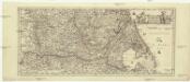
[Nizozemsko]
1 : 970000 Belgie
Königreich Niederland und Königreich Belgien dann das Herzgth. Luxemburg
1 : 1200000 Belgie T. Mollo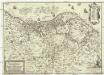
Nova et accurata XVII. Germaniae inferioris provinciarum delineatio et repraesentatio
1 : 860000 Nizozemsko I. H. S. Hipschmann, Sigmund Gabriel Johann Hofmann
Charte des Königreichs Holland
1 : 650000 Nizozemsko Stieler, Adolf Streit, Friedrich Wilhelm
Charte des Königreichs Holland
1 : 650000 Nizozemsko Stieler, Adolf Streit, Friedrich Wilhelm
Charte des Königreichs Holland
1 : 650000 Nizozemsko Stieler, Adolf Streit, Friedrich Wilhelm
CHARTE des KÖNIGREICHS HOLLAND
1 : 640000 Nizozemsko Stieler, Adolf Streit, Friedrich Wilhelm
Charte des Königreichs Holland
1 : 650000 Nizozemsko Stieler, Adolf Streit, Friedrich Wilhelm