Maps of Nordrhein-Westfalen

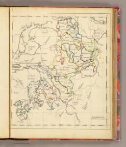
Westphalia.
1 : 2000000 Bowen, Frances
Postkarte von dem Westphaelischen und Burgundischen Kreise
Burgundsko (Francie) Kühn, Ignaz im von Reilly'schen Landkarten und Kunstwerke Verschleiss Komptoir
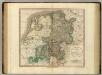
Charte über die saemtlichen zum Westphaelischen Kreis gehörige Laender
1 : 834000 Vestfálsko (Německo) Güssefeld, Franz L. Homaenischen Erben
Accuratissima Rheni inferioris Mosae et Mosellae tabula ac minores in eosdem influentes fluvii
1 : 950000 1 Karte : Kupferdruck ; 49 x 57 cm Danckerts, Theodorus [Danckerts]
Le Cours de la Riviere du Rhein
1 : 1100000 Mollova mapová sbírka Sanson, Guillaume Schenk, Peter I
Il Corso del Fivme Reno d'Allemagna, dalla Mosella fino al Mare. con tuttu li Dominij che si trouano nelle uicinanze del medesimo Fiume, rappresentati conforme lo stato presente da Giacomo Cantelli da Vignola Geografo del Ser.mo Sig. Dvca di Modena etc. 1689
Mollova mapová sbírka Cantelli, Giacomo Barbey, Antonio De Rossi, Giovanni Giacomo
Le Cours de la Riviere du Rhein
1 : 1100000 Mollova mapová sbírka Sanson, Guillaume Mortier, Pierre
Charte über die sæmtlichen zum Westphælischen Kreis gehörige Lænder
1 Karte : Kupferdruck ; 52 x 47 cm Güssefeld bey den Homænnischen Erben
Tabula Geographica qua Pars Septentrionalis sive Inferior Rheni, Mosae et Moselle
1 : 1100000 Mollova mapová sbírka Visscher, Nicolaes Jansz. Visscher, Nicolaus
Tabula Geographica qua Pars Septentrionalis sive Inferior Rheni, Mosae et Moselle
1 : 1100000 Mollova mapová sbírka Visscher, Nicolaes Jansz. Visscher, Nicolaus
[Nordwestliches Deutschland und Kgr. Der Niederlande]
Stieler's Hand-Atlas Stieler, Adolf bei Justus Perthes
Totius FLUMINIS RHENI Novissima DESCRIPTIO
1 : 910000 Nizozemsko Visscher, Nicolaes Jansz. ex officina N. Visscher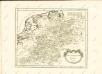
Westphalia.
1 : 1020000 Cary, John, ca. 1754-1835
Totius Rheni, ab eius capitibus ad oceanum usque Germanicum in quem se exonerat novißima descriptio
1 : 1025000 Belgie Hondius, Henricus Keere, Pieter van den sumptibus Henrici Hondii
Rheinprovinz, Westphalen, Holland und Belgien
Schul-Atlas in 36 Karten Völter, Daniel Verlag der J.M. Dannheimer'schen Buchhandlung
Holland und Berg
Allgemeiner Atlas [Walch, Johannes] im Verlag bei Johannes Walch
Le cours du Rhin
1 : 750000 dressée sur les nouvelles observations par Le Rouge A Paris : [Le Rouge], Rue des Augustins
Cercle de Westphalie
1 : 1720000 Vestfálsko (Německo) Bonne, Rigobert André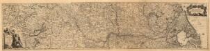
Totius Rheni â fontibus usque ad Ostia Novissima Descriptio
1 : 530000 Mollova mapová sbírka Bodenehr, Johann Georg Neureutter, Augustin
Charte über die saemtlichen zum Westphaelischen Kreis gehörige Laender
1 : 840000 Evropa severozápadní Güssefeld, Franz L. bey den Homaennischen Erben

Totius fluminis Rheni novissima descriptio
1 : 820000 Evropa západní Danckerts, Justus I. Danckerts
Totius Fluminis Rheni Novissima Descriptio
1 : 820000 Mollova mapová sbírka Danckerts, Justus Danckerts, Justus
Totius Fluminis Rheni Novissima Descriptio
1 : 790000 Mollova mapová sbírka Visscher, Nicolaes Jansz. Schenk, Peter I
Theatre de la Guerre en Allemagne et dans les Pays Bas.
1 : 1100000 Mollova mapová sbírka Nolin, Jean-Baptiste Nolin, Jean-Baptiste I.
Operationen der alliirten und französischen Armee 1759


Neue und richtige Landtafel der XVII Niderländische Provincien : abbildende alle befestigte, bemauerte, offene Stedte und Schantzen, etc.
1 : 1260000 Annotatie geografische gegevens: Noordwest boven Nürnberg : Jacob Sandrart