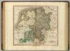
Maps of Nordrhein-Westfalen

Le cours du Rhin
1 : 750000 dressée sur les nouvelles observations par Le Rouge A Paris : [Le Rouge], Rue des Augustins

Le Cours de la Riviere du Rhein
1 : 1100000 Mollova mapová sbírka Sanson, Guillaume Mortier, Pierre
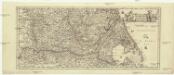
Tabula Geographica qua Pars Septentrionalis sive Inferior Rheni, Mosae et Moselle
1 : 1100000 Mollova mapová sbírka Visscher, Nicolaes Jansz. Visscher, Nicolaus
Tabula Geographica qua Pars Septentrionalis sive Inferior Rheni, Mosae et Moselle
1 : 1100000 Mollova mapová sbírka Visscher, Nicolaes Jansz. Visscher, Nicolaus
Westphalia.
1 : 2000000 Bowen, Frances
Le Cours de la Riviere du Rhein
1 : 1100000 Mollova mapová sbírka Sanson, Guillaume Schenk, Peter I
Accuratissima Rheni inferioris Mosae et Mosellae tabula ac minores in eosdem influentes fluvii
1 : 950000 1 Karte : Kupferdruck ; 49 x 57 cm Danckerts, Theodorus [Danckerts]
Westphalia.
1 : 1020000 Cary, John, ca. 1754-1835
Postkarte von dem Westphaelischen und Burgundischen Kreise
Burgundsko (Francie) Kühn, Ignaz im von Reilly'schen Landkarten und Kunstwerke Verschleiss Komptoir
[No. 4. Cöln], uit: [Carte de l'Europe]
1 : 490000 Paris : Piquet
Laender zwischen der Maas und der Elbe
1 : 1442000 Labe-oblast (Česko a Německo) Tranquillo Mollo
Cercle de Westphalie
1 : 1720000 Vestfálsko (Německo) Bonne, Rigobert André
Il Corso del Fivme Reno d'Allemagna, dalla Mosella fino al Mare. con tuttu li Dominij che si trouano nelle uicinanze del medesimo Fiume, rappresentati conforme lo stato presente da Giacomo Cantelli da Vignola Geografo del Ser.mo Sig. Dvca di Modena etc. 1689
Mollova mapová sbírka Cantelli, Giacomo Barbey, Antonio De Rossi, Giovanni Giacomo
Charte über die saemtlichen zum Westphaelischen Kreis gehörige Laender
1 : 834000 Vestfálsko (Německo) Güssefeld, Franz L. Homaenischen Erben
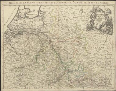
Kriegsschauplatz der Maas und Sambre Armeen
1 : 2780000 Belgie
Estat et Seigneurie de l'Eves.ché de Lyege
1 : 240000 Mollova mapová sbírka Sanson, Guillaume Jaillot, Alexis Hubert
Charte von den Grosherzogthümern Berg und Hessen, den Fürstlich-Primatischen Laendern; dem Herzogthume Nassau und den übrigen darinne begränzten, zum Theil noch uneingetheilten Laendern
1 : 820000 Streit, Friedrich Wilhelm Verl. des Geograph. Inst.
Charte über die sæmtlichen zum Westphælischen Kreis gehörige Lænder
1 Karte : Kupferdruck ; 52 x 47 cm Güssefeld bey den Homænnischen Erben
Holland und Berg
Allgemeiner Atlas [Walch, Johannes] im Verlag bei Johannes Walch
Patriae Antique Inter Iuly et Caroli Magni Caesarum Romanorum Tempora Descriptio
1 : 1100000 Mollova mapová sbírka Ewich, Hermann Saevry, S.
Brabantia III. Rheni Et X. Nova Tabula. [Karte], in: Claud. Ptolemaeus. Geographia lat. cum mappis [...], S. 371.
1 Karte aus Atlas Münster, Sebastian [und Ptolemaeus, Claudius]
Rheinprovinz, Westfalen, Hessen-Nassau, Waldeck, Grossherzogthum Hessen.
1 : 1000000 Andree, Richard
Rhenish Prussia, Westphalia, Hesse-Nassau, Waldeck, Lippe, Hesse.
1 : 1000000 Andree, Richard; Times (London, England)
Totius Fluminis Rheni Novissima Descriptio [Karte, Teil 2], in: Novus atlas absolutissimus, Bd. 2, S. 150.
1 Karte aus Atlas Janssonius Offizin
Operationen der alliirten und französischen Armee 1759

XVII Provinciarum Inferioris Germaniae
1 : 1200000 Mollova mapová sbírka Visscher, Nicolaes Fuchs, Jobst Christoph
XVII Provinciarum Inferioris Germaniae
1 : 1200000 Mollova mapová sbírka Visscher, Claes Jansz. Goos, Abraham Visscher, Claes Janszoon