Maps of Poland

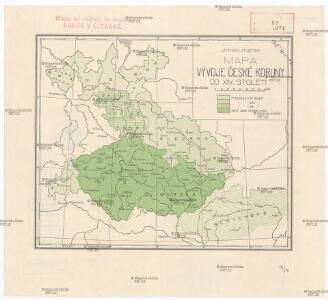
Mapa vývoje České koruny od XIV. století
1 : 3900000 Česko Hocke, Jan Kapras, Jan
General Carte der gesammten Königlichen Preussischen Länder
1 : 1800000 Mollova mapová sbírka Schleuen, Johann David Schleuen, Johann David
Sbírka map a diagramů použitých na mírových konferencích v Paříži v letech 1919 - 1920
Mapa historického vývoje Československého státu (od XIV. do XIX. století)
France 2.
1 : 1170000 Brue, Adrien Hubert, 1786-1832; Herisson, Eustache, b. 1759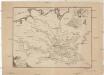
Ideal Postcharte von Boehmen
Evropa střední Berka, Jan Wenzel Schwarz
Ideal Postcharte von Boehmen
Evropa střední Berka, Jan Wenzel Schwarz
Czechoslovakia.
From Czechoslovakia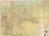
Strassenzustandskarte von Deutschland

Germany : International frontiers 1937 : internal boundaries 1944
1 : 1600000 [London] : [War Office]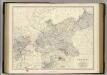
Prussia.
1 : 2032000 Johnston, Alexander Keith, 1804-1871
Preussischer Staat.
1 : 2800000 Flemming, Carl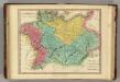
Germania Antiqua. (1826)
1 : 4400000 Tanner, Henry S.
[Polsko]
Polsko
[Polsko]
Polsko
Parte Orientale della Germania Diuisa Ne Suoi Stati
1 : 2100000 Mollova mapová sbírka Coronelli, Vincenzo Maria
Parte Orientale della Germania Diuisa Ne Suoi Stati
1 : 2100000 Mollova mapová sbírka Coronelli, Vincenzo Maria
Obec českého národa
1 : 3400000 Evropa střední Kuffner, Hanuš
Prussia.
1 : 3200000 Tanner, Henry S.
Brüssel

Circuli Austriaci Pars Occidentalior, Comprehendens Comitatum Principalem Tirolis Episcopatus Tridentinum et Brixensem Comitatus Brigantinum Feldkirchiae Sonnebergae Pluentii etc.
1 : 558000 Mollova mapová sbírka Wit, Frederik de Wit, Frederick
III. vojenské mapování 3959
1 : 75000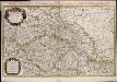
Estats de la couronne de Boheme qui comprennent le Royaume de Boheme le Duché de Silesie et les Marquisats de Moravie et de Lusace / par le Sr. Sanson, geographe ordinaire du Roy
1 : 925000 Annotatie: Auec priuilege du Roy, pour vingt ans; Koptitel: Estats de la couronne de Boheme, ou sont le Royaume de Boheme, le Duché de Silesie, les Marquisats de Moravie, et de Lusace, subdivisés en leurs principales parties, dressé sur les memoires les plus nouueaux, par le Sr. Sanson ...; Origineel is Blad 126 in atlas factice; Annotatie geografische gegevens: Met 6 schaalstokken Guillaume Sanson 1633-1703 A Paris : chez H. Iaillot, joignant les grands Augustins, aux deux globes
Polen u. Nachbarländer 963 bis 992
1 : 12000000 Polen
Partie, l'Allemagne. Europe 14.
1 : 1641836 Vandermaelen, Philippe, 1795-1869
Základ zkázy nezvratné
1 : 5000000 Morava (Česko) Kuffner, Hanuš
Bunt- und Edelmetallbergbau und Saigerhütten in Mitteleuropa 1419-1540
Mitteleuropa Bergbau, Hüttenindustrie