Maps of Poland

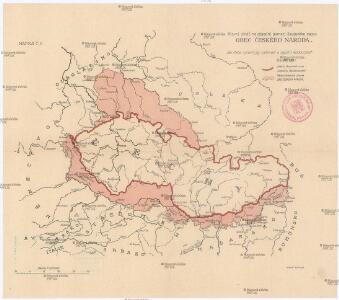
Obec českého národa
1 : 3400000 Evropa střední Kuffner, Hanuš
Bunt- und Edelmetallbergbau und Saigerhütten in Mitteleuropa 1419-1540
Mitteleuropa Bergbau, Hüttenindustrie
Základ zkázy nezvratné
1 : 5000000 Morava (Česko) Kuffner, Hanuš
Die Haupt-Verkehrs-Richtungen auf deutschen Eisenbahnen hinsichtlich ihrer merkantilen Bedeutung durch Farben veranschaulicht
1 : 2000000 Loeben, W.K. von Weingartner
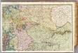
Illustrirte politische Karte von Österreich und den angränzenden Ländern
Evropa jihovýchodní
Rand McNally Popular map of Germany and Hungary
1 : 3992000 Rand McNally & Company
France 2.
1 : 1170000 Brue, Adrien Hubert, 1786-1832; Herisson, Eustache, b. 1759
Reise und Influenz-Karte der Eil- Post- und Brancard-Wagen-Course in dem Oesterreichischen Kaiserstaate
Evropa střední Raffelsperger, Franz Bermann, J. Franz Raffelsperger
Reise und Influenz-Karte der Eil- Post- und Brancard-Wagen-Course in dem Oesterreichischen Kaiserstaate
Evropa střední Raffelsperger, Franz Haupt-Direction der k. k. Fahrposten
Velkoněmecká říše, Protektorát Čechy a Morava, Gen.- Guvernement, Slovensko a Švýcarsko

Austrian Dominions.
1 : 5200000 Arrowsmith, Aaron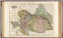
Austrian Dominions.
1 : 1930000 Pinkerton, John, 1758-1826
Austrian Dominions.
1 : 5200000 Arrowsmith, Aaron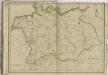
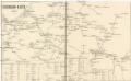
Eisenbahn-Karte
Evropa střední
[XIII], uit: Geognostische Karte des Oesterreichischen Kaiserstaates mit einem grossen Theile Deutschland's u. Italien / hauptsachlich nach ... Haidinger's geognostischer Karte dieses Staates bearb. von Josef Scheda
1 : 3000000 titelvariant: General-Karte von Europa in 25 Blättern; Annotatie: Bijlage bij: General-Karte von Europa in 25 Blättern. - 1:2.592.000. - 1845-1847 Scheda, Joseph Wien : K.K. Militär. Geografisch. Institut
Vývoj Státu československého
1 : 2800000 Česko Hocke, Jan B. Kočí
Československá republika

Die hist. Entwicklung von Brandenburg-Preussen seit 1415
Mitteleuropa, Preußen, Expansion
Territoriale Entwickelung des Brandenburg-Preussischen Staates
Volksschul-Atlas über alle Teile der Erde Lange, Henry Druck und Verlag von Georg Westermann
Germany, Switzerland, Holland.
1 : 6500000 Peterson, Augusts
Prussia.
1 : 2600000 Mitchell, Samuel Augustus
Prussia.
1 : 2600000 Mitchell, Samuel Augustus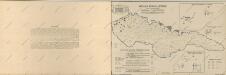
Atlas d'industrie de la république tchécoslovaque

Allemagne, Pologne, Tchecoslovaquie.
1 : 2500000 Vivien St Martin, L.
Czechoslovakia.
From Czechoslovakia
Brüssel

[Recto], uit: Eisenbahnkarte
1 : 2250000 Leipzig : Lissel