Maps of Libya

Lybia (Tripolitania y Cyenaica)
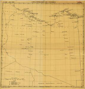
Libya (Tripolitania and Cyenaica), ADI (Maps) AM 180. [S.l.] : Air Ministry, United Kingdom, [19--]
113-14. Libia.
1 : 5000000 Touring club italiano
Spezial-Karte von Afrika
1 : 4000000 Blatt 2 Habenicht, Hermann Perthes
Karte der Nordküste Afrika's
Afrika severní Voss, C. L. Reimer
Tripoli & Egypt
1 : 3000000 Egypt E. Stanford
An accurate map of west Barbary, including Suse & Tafilelt, forming the dominions of the present emperor of Marocco
Maroko Jackson, James Grey Neele, Samuel John G. & W. Nicoll
Africa 1:2.000.000, Fezzan
Fezzan, Libya
Aegypten.
1 : 3000000 Radefeld, Carl Christian Franz, 1788-1874
Eastern Libya, Aerodrome Map
Aerodrome map of Eastern Libya, DR 326. Great Britain. Army. Royal Engineers. Field Survey Company, 512th. [Cairo] : [Survey Directorate, Middle East]
Western Libya, Aerodrome Map
Aerodrome map of Western Libya, DR 326. Great Britain. Army. Royal Engineers. Field Survey Company, 512th. [Cairo] : [Survey Directorate, Middle East]
Partie du Fezzan. Afrique 9.
1 : 1641836 Vandermaelen, Philippe, 1795-1869
Partie du Fezzan. Afrique 10.
1 : 1641836 Vandermaelen, Philippe, 1795-1869
Tripoli.
1 : 2000000 Society for the Diffusion of Useful Knowledge (Great Britain)
Partie du Sahara. Afrique 16.
1 : 1641836 Vandermaelen, Philippe, 1795-1869
Een gedeelte van de kust van Barbarija beginnende van P. Soliman tot C. Mezurata
Libya Gerard van Keulen
Feuille 46 (D VII), uit: Carte géologique internationale de l'Europe : la carte, votée au congrès géologique international de Bologne en 1881, est exécutée conformément aux décisions d'une commission internationale, avec le concours des gouvernements, sous le dir. de M.M. Beyrich et Hauchecorne
Annotatie: Blad 48 gamme des couleurs; blad 49: bladwijzer en titelblad Heinrich Ernst Beyrich 1815-1896; Wi. Hauchecorne Berlin : Reimer / (Berlin: Institut lithographique)
[XXIII], uit: Geognostische Karte des Oesterreichischen Kaiserstaates mit einem grossen Theile Deutschland's u. Italien / hauptsachlich nach ... Haidinger's geognostischer Karte dieses Staates bearb. von Josef Scheda
1 : 3000000 titelvariant: General-Karte von Europa in 25 Blättern; Annotatie: Bijlage bij: General-Karte von Europa in 25 Blättern. - 1:2.592.000. - 1845-1847 Scheda, Joseph Wien : K.K. Militär. Geografisch. Institut
Partie, Tunis et Tripoli. Afrique 3.
1 : 1641836 Vandermaelen, Philippe, 1795-1869
Barca. Afrique 4.
1 : 1641836 Vandermaelen, Philippe, 1795-1869
Africa 1:2.000.000, Cyrenaica
Cyrenaica, Libya
Desert de Lybie. Afrique 17.
1 : 1641836 Vandermaelen, Philippe, 1795-1869
Feuille 45 (C VII), uit: Carte géologique internationale de l'Europe : la carte, votée au congrès géologique international de Bologne en 1881, est exécutée conformément aux décisions d'une commission internationale, avec le concours des gouvernements, sous le dir. de M.M. Beyrich et Hauchecorne
Annotatie: Blad 48 gamme des couleurs; blad 49: bladwijzer en titelblad Heinrich Ernst Beyrich 1815-1896; Wi. Hauchecorne Berlin : Reimer / (Berlin: Institut lithographique)
Neue Charte der Canarien Inseln
Kanárské ostrovy Linschoten, Jan Huygen van Bory de Saint-Vincent, Jean-Baptist Genevieve Marcellin
Isles de Madere, de Porto Santo, et celles des Salvages
Madeira (Madeirské souostroví) Bonne, Rigobert André
Een gedeelte van de kust van Barbaria tusschen C. Capudia en C. Mesurata int grood
Libya Gerard van Keulen
[Střední Maroko]
Maroko Zeithammer, Antonín Otakar Badía y Leblich, Domingo
Egypt and Cyrenaica 1:250,000, Bengasi (Benghazi)
Egypt and Cyrenaica 1:250,000 , Series GSGS 4386. Great Britain. Army. Middle East Command. [London] : War Office.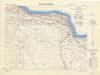
Egypt and Cyrenaica 1:250,000, Salum-Torbruch
Egypt and Cyrenaica 1:250,000 , Series GSGS 4386. Great Britain. Army. Middle East Command. [London] : War Office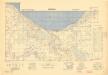
Egypt and Cyrenaica 1:250,000, Agheila
Egypt and Cyrenaica 1:250,000 , Series GSGS 4386. Great Britain. Army. Middle East Command. [London] : War Office