Maps of Jabal Nafüsah

Maps of Jabal Nafüsah

$title$

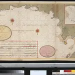
Een gedeelte van de kust van Barbaria tusschen C. Capudia en C. Mesurata int grood

Libya Gerard van Keulen
$title$

Insularum Aliquot Maris Mediterranei Descriptio. [Zerbi] [Karte], in: Theatrum orbis terrarum, S. 335.

1 Karte aus Atlas Ortelius, Abraham Vrients, Jan Baptista
$title$

Insularum Aliquot Maris Mediterranei Descriptio. [Zerbi] [Karte], in: Theatrum orbis terrarum, S. 240.

1 Karte aus Atlas Ortelius, Abraham
$title$

Insularum Aliquot Maris Mediterranei Descriptio. [Zerbi] [Karte], in: Theatrum orbis terrarum, S. 91.

1 Karte aus Atlas Ortelius, Abraham
$title$

Tripoli

1 : 25000 Tripolis (Libye) Istituto geografico militare
$title$

De haven en stad Tripoli geleegen agter in de Middellandsche Zee, aen de cust van Barbarijen

Libya Gerard van Keulen
$title$

Port ou rade, de haven van Tripoli

Libya Gerard van Keulen
$title$

De haven of baij van Tripoli in Barbarijen geleegen agter in de Middellandse Zee

Libya Gerard van Keulen
$title$

Tunis, Tripoli.

1 : 2000000 Society for the Diffusion of Useful Knowledge (Great Britain)
$title$

Carte De La Mer Mediterranee. VI.

Roux, Joseph
$title$

Partie, Tunis et Tripoli. Afrique 3.

1 : 1641836 Vandermaelen, Philippe, 1795-1869
$title$

Stato di Tunisi.

1 : 2000000 Marzolla, Benedetto
$title$

Neueste Karte von Tunis

Grosser Hand-Atlas über alle Theile der Erde in 170 Karten Meyer, J. Verlag des Bibliographischen Instituts
$title$

Tunis.

1 : 2000000 Radefeld, Carl Christian Franz, 1788-1874
$title$

Tunis u. westl. Theil von Tripoli

1 : 2000000 Libye C. Flemming
$title$

Feuille 45 (C VII), uit: Carte géologique internationale de l'Europe : la carte, votée au congrès géologique international de Bologne en 1881, est exécutée conformément aux décisions d'une commission internationale, avec le concours des gouvernements, sous le dir. de M.M. Beyrich et Hauchecorne

Annotatie: Blad 48 gamme des couleurs; blad 49: bladwijzer en titelblad Heinrich Ernst Beyrich 1815-1896; Wi. Hauchecorne Berlin : Reimer / (Berlin: Institut lithographique)
$title$

Africa 1:2.000.000, Tunisie

Tripolitania, Libya (also Tunisia)
$title$

Charte du Royaume d'Alger

1 : 3800000 Alžírsko Weiland, Karl Ferdinand Kaiser, F.
$title$

Carte de la Régence de Tripoli et des principales routes commerciales de l'interieur de l'Afrique : d'après les observations de Mr. Prax, les renseignements recueillis par ce voyageur et les études faites par Mr. Renou

1 : 2000000 dressée par MM. Prax et Renou d'après les observations de Mr. Prax, les renseignements recueillis par ce voyageur, et les études faites par Mr. Renou gravée sur pierre par F. Delamare Paris : Lemercier
$title$

An accurate map of west Barbary, including Suse & Tafilelt, forming the dominions of the present emperor of Marocco

Maroko Jackson, James Grey Neele, Samuel John G. & W. Nicoll
$title$

Africae Propriae Tabula, In qua, Punica regna vides; Tyrios, et Agenoris urbem. [Karte], in: Theatrum orbis terrarum, S. 439.

1 Karte aus Atlas Ortelius, Abraham
$title$

[XXIII], uit: Geognostische Karte des Oesterreichischen Kaiserstaates mit einem grossen Theile Deutschland's u. Italien / hauptsachlich nach ... Haidinger's geognostischer Karte dieses Staates bearb. von Josef Scheda

1 : 3000000 titelvariant: General-Karte von Europa in 25 Blättern; Annotatie: Bijlage bij: General-Karte von Europa in 25 Blättern. - 1:2.592.000. - 1845-1847 Scheda, Joseph Wien : K.K. Militär. Geografisch. Institut
$title$

Letecká navigační mapa

$title$

Western Libya, Aerodrome Map

Aerodrome map of Western Libya, DR 326. Great Britain. Army. Royal Engineers. Field Survey Company, 512th. [Cairo] : [Survey Directorate, Middle East]
$title$

Afrika

$title$

Carte générale de l'Algérie à l'échelle de 1 m. pour 1,600,000 m

1 : 1600000 Ostblatt Duveyrier, Henri Dépôt de la Guerre
$title$

[Septima Europe tabula] [Karte], in: Clavdii Ptholomei Viri Alexandrini Cosmographie, S. 149.

1 Karte aus Atlas Nicolaus Germanus [und Ptolemaeus, Claudius]
$title$

Tunis, Tripoli.

1 : 2000000 Flemming, Carl
$title$

萬國通鑑:羅馬國

美国传教士撰的向中国人介绍世界地理概况的著作,后有世界地图册1份,共13幅世界、大洲和区域地图,其中一幅题为《中國地圖》的清朝内地地图。 Sheffield, Devello Zelotos 謝衛樓 福州 : 美華書局
$title$

Carte des chemins de fer de l'Algérie et de la Tunisie

1 : 3000000 Alžírsko Chaix
© MapTiler © OpenStreetMap contributors
How does it work?
These instructions will show you how to find historical maps online.
Getting started
Type the place name in the search box to find the exact location. You can further adjust the search by zooming in and out.
Zoom
Zoom in and out with the buttons or use your mouse or touchpad natively.
Exact Area tool
Click here and draw a rectangle over the map to precisely define the search area.
Set filters
Narrow your search with advanced settings, such as Years (from/to), Fulltext, Publisher, etc.
Results
See the results of your search on the right side. You can scroll down to find more maps of this location.
?

Download OldMapsOnline Mobile