Maps of Jabal As Sawdä
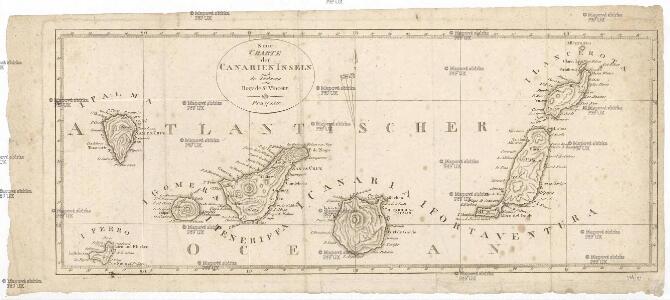
Neue Charte der Canarien Inseln
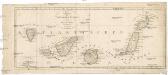
Kanárské ostrovy Linschoten, Jan Huygen van Bory de Saint-Vincent, Jean-Baptist Genevieve Marcellin
Charte von der Insel Teneriffa
Tenerife (Kanárské ostrovy) Homann, Johann Christoph Bory de Saint-Vincent, Jean-Baptist Genevieve Marcellin
Tripoli.
1 : 2000000 Society for the Diffusion of Useful Knowledge (Great Britain)
Partie du Fezzan. Afrique 9.
1 : 1641836 Vandermaelen, Philippe, 1795-1869
Aegypten.
1 : 3000000 Radefeld, Carl Christian Franz, 1788-1874
Western Libya, Aerodrome Map
Aerodrome map of Western Libya, DR 326. Great Britain. Army. Royal Engineers. Field Survey Company, 512th. [Cairo] : [Survey Directorate, Middle East]
Partie du Fezzan. Afrique 10.
1 : 1641836 Vandermaelen, Philippe, 1795-1869
Marocco, Algier und Tunis
Maroko Radefeld Kleinknecht
Carte de la Régence de Tripoli et des principales routes commerciales de l'interieur de l'Afrique : d'après les observations de Mr. Prax, les renseignements recueillis par ce voyageur et les études faites par Mr. Renou
1 : 2000000 dressée par MM. Prax et Renou d'après les observations de Mr. Prax, les renseignements recueillis par ce voyageur, et les études faites par Mr. Renou gravée sur pierre par F. Delamare Paris : Lemercier
Karte von Fes und Marócos
Afrika severní Bruns, Paul Jakob Anville, Jean-Baptiste Bourguinon d' Weigel- und Schneiderschen Handlung
Schul-Atlas für die alte Erdbeschreibung : zur allgemeinen Schul-encyclopädie gehörig
J. H. Campe Zusammensetzung und Zeichnung von [...] Dufour, unter Leitung von Heusinger ; gestochen von Frentzel. Braunschweig : Schulbuchhandlung
Ancient Africa or Libya II.
1 : 5100000 Society for the Diffusion of Useful Knowledge (Great Britain)
Tripoli & Egypt
1 : 3000000 Egypt E. Stanford
Sev. Afrika

Africa propria degli antichi, Numidia, Mauritania cesariense
1 : 6000000 [Marzolla, B.] [Verlag nicht ermittelbar]
Tunis et Tripoli
Nouvel atlas physique politique et historique de l'Empire ottoman et des états limitrophes en Europe, en Asie et en Afrique, en quarante feuilles Hellert, J.J. Bellizard, Dufour et Cie
Afrique Propre.
1 : 3800000 Lapie, M. (Pierre), 1779-1850
Lybia (Tripolitania y Cyenaica)
Libya (Tripolitania and Cyenaica), ADI (Maps) AM 180. [S.l.] : Air Ministry, United Kingdom, [19--]
Karte der Nordküste Afrika's
Afrika severní Voss, C. L. Reimer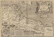
Africae Propriae Tabula, In qua, Punica regna vides; Tyrios, et Agenoris urbem. [Karte], in: Theatrum orbis terrarum, S. 523.
1 Karte aus Atlas Ortelius, Abraham Vrients, Jan Baptista
Secunda Affrice Tabula [Karte], in: [Clavdii Ptholomei Cosmographi ...], S. 290.
1 Karte aus Atlas Nicolaus Germanus [und Ptolemaeus, Claudius]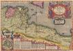
Africae Propriae Tabula, In qua, Punica regna vides; Tyrios, et Agenoris urbem. [Karte], in: Theatrum orbis terrarum, S. 439.
1 Karte aus Atlas Ortelius, Abraham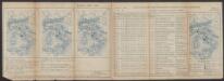
Bullettino decadico dell'osservatorio ed archivio centrale geodinamico
1 : 1200000 1885/5, Blatt 1 Archivio Centrale Geodinamico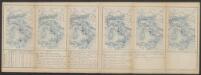
Bullettino decadico dell'osservatorio ed archivio centrale geodinamico
1 : 1200000 1885/30, Blatt 2 Archivio Centrale Geodinamico
Bullettino decadico dell'osservatorio ed archivio centrale geodinamico
1 : 1200000 1885/28, Blatt 1 Archivio Centrale Geodinamico
Aphricae Tabula II. [Karte], in: Geographia universalis vetus et nova complectens Claudii Ptolemaei Alexandrini enarrationis libros VIII, S. 257.
1 Karte aus Atlas Münster, Sebastian [und Ptolemaeus, Claudius]
Spezial-Karte von Afrika
1 : 4000000 Blatt 2 Habenicht, Hermann Perthes
113-14. Libia.
1 : 5000000 Touring club italiano
In notitiam ecclesiasticam Africæ tabula geographica
1 : 5700000