Maps of Sirte

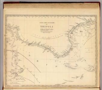
Tripoli.
1 : 2000000 Society for the Diffusion of Useful Knowledge (Great Britain)
Isles de Madere, de Porto Santo, et celles des Salvages
Madeira (Madeirské souostroví) Bonne, Rigobert André
Egypt and Cyrenaica 1:250,000, Bengasi (Benghazi)
Egypt and Cyrenaica 1:250,000 , Series GSGS 4386. Great Britain. Army. Middle East Command. [London] : War Office.
Neue Charte der Canarien Inseln
Kanárské ostrovy Linschoten, Jan Huygen van Bory de Saint-Vincent, Jean-Baptist Genevieve Marcellin
Egypt and Cyrenaica 1:250,000, Agheila
Egypt and Cyrenaica 1:250,000 , Series GSGS 4386. Great Britain. Army. Middle East Command. [London] : War Office
Charte von der Insel Teneriffa
Tenerife (Kanárské ostrovy) Homann, Johann Christoph Bory de Saint-Vincent, Jean-Baptist Genevieve Marcellin
Cyrenaica, Lybia, Baracca
Ente Colonizzazione Libia, comprensorio [district]. One of a collection of maps of districts in Libya; reproduced from Italian originals. [S.l.] : 512 Fd. Survey Co. R.E.
Cyrenaica, Lybia, D'Annunzio
Ente Colonizzazione Libia, comprensorio [district]. One of a collection of maps of districts in Libya; reproduced from Italian originals. [S.l.] : 512 Fd. Survey Co. R.E.
Carta topografica della Cirenaica
1 : 50000 Istituto geografico militare
Cyrenaica, Lybia, Oberdan
Ente Colonizzazione Libia, comprensorio [district]. One of a collection of maps of districts in Libya; reproduced from Italian originals. [S.l.] : 512 Fd. Survey Co. R.E.
Cyrenaica, Lybia, Razza
Ente Colonizzazione Libia, comprensorio [district]. One of a collection of maps of districts in Libya; reproduced from Italian originals. [S.l.] : 512 Fd. Survey Co. R.E.
Cyrenaica, Lybia, Luigi Di Savoia
Ente Colonizzazione Libia, comprensorio [district]. One of a collection of maps of districts in Libya; reproduced from Italian originals. [S.l.] : 512 Fd. Survey Co. R.E.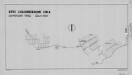
Cyrenaica, Lybia, Mameli
Ente Colonizzazione Libia, comprensorio [district]. One of a collection of maps of districts in Libya; reproduced from Italian originals. [S.l.] : 512 Fd. Survey Co. R.E.
Cyrenaica, Lybia, Battisti
Ente Colonizzazione Libia, comprensorio [district]. One of a collection of maps of districts in Libya; reproduced from Italian originals. [S.l.] : 512 Fd. Survey Co. R.E.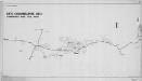
Cyrenaica, Lybia, Berta
Ente Colonizzazione Libia, comprensorio [district]. One of a collection of maps of districts in Libya; reproduced from Italian originals. [S.l.] : 512 Fd. Survey Co. R.E.
Eastern Libya, Aerodrome Map
Aerodrome map of Eastern Libya, DR 326. Great Britain. Army. Royal Engineers. Field Survey Company, 512th. [Cairo] : [Survey Directorate, Middle East]
Feuille 46 (D VII), uit: Carte géologique internationale de l'Europe : la carte, votée au congrès géologique international de Bologne en 1881, est exécutée conformément aux décisions d'une commission internationale, avec le concours des gouvernements, sous le dir. de M.M. Beyrich et Hauchecorne
Annotatie: Blad 48 gamme des couleurs; blad 49: bladwijzer en titelblad Heinrich Ernst Beyrich 1815-1896; Wi. Hauchecorne Berlin : Reimer / (Berlin: Institut lithographique)
Carte De La Mer Mediterranee. VIII.
Roux, Joseph
Barca. Afrique 4.
1 : 1641836 Vandermaelen, Philippe, 1795-1869
Een gedeelte van de kust van Barbarija beginnende van P. Soliman tot C. Mezurata
Libya Gerard van Keulen
Western Libya, Aerodrome Map
Aerodrome map of Western Libya, DR 326. Great Britain. Army. Royal Engineers. Field Survey Company, 512th. [Cairo] : [Survey Directorate, Middle East]
Partie du Fezzan. Afrique 10.
1 : 1641836 Vandermaelen, Philippe, 1795-1869
Egypt and Cyrenaica 1:250,000, Derna
Egypt and Cyrenaica 1:250,000 , Series GSGS 4386. Great Britain. Army. Middle East Command. [London] : War Office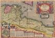
Africae Propriae Tabula, In qua, Punica regna vides; Tyrios, et Agenoris urbem. [Karte], in: Theatrum orbis terrarum, S. 439.
1 Karte aus Atlas Ortelius, Abraham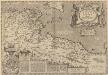
Africae Propriae Tabula, In qua, Punica regna vides; Tyrios, et Agenoris urbem. [Karte], in: Theatrum orbis terrarum, S. 523.
1 Karte aus Atlas Ortelius, Abraham Vrients, Jan Baptista
Ancient Africa or Libya II.
1 : 5100000 Society for the Diffusion of Useful Knowledge (Great Britain)
Tripoli & Egypt
1 : 3000000 Egypt E. Stanford
Sev. Afrika

Tunis et Tripoli
Nouvel atlas physique politique et historique de l'Empire ottoman et des états limitrophes en Europe, en Asie et en Afrique, en quarante feuilles Hellert, J.J. Bellizard, Dufour et Cie