Maps of Libyan Plateau

Africa 1:2.000.000, Cyrenaica
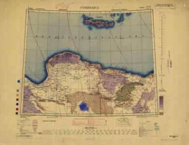
Cyrenaica, Libya
Eastern Libya, Aerodrome Map
Aerodrome map of Eastern Libya, DR 326. Great Britain. Army. Royal Engineers. Field Survey Company, 512th. [Cairo] : [Survey Directorate, Middle East]
Feuille 47 (E VII), uit: Carte géologique internationale de l'Europe : la carte, votée au congrès géologique international de Bologne en 1881, est exécutée conformément aux décisions d'une commission internationale, avec le concours des gouvernements, sous le dir. de M.M. Beyrich et Hauchecorne
Annotatie: Blad 48 gamme des couleurs; blad 49: bladwijzer en titelblad Heinrich Ernst Beyrich 1815-1896; Wi. Hauchecorne Berlin : Reimer / (Berlin: Institut lithographique)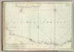
Carte De La Mer Mediterranee. IX.
Roux, Joseph
Barca. Afrique 4.
1 : 1641836 Vandermaelen, Philippe, 1795-1869
Feuille 46 (D VII), uit: Carte géologique internationale de l'Europe : la carte, votée au congrès géologique international de Bologne en 1881, est exécutée conformément aux décisions d'une commission internationale, avec le concours des gouvernements, sous le dir. de M.M. Beyrich et Hauchecorne
Annotatie: Blad 48 gamme des couleurs; blad 49: bladwijzer en titelblad Heinrich Ernst Beyrich 1815-1896; Wi. Hauchecorne Berlin : Reimer / (Berlin: Institut lithographique)
Tripoli, Egypt.
1 : 2000000 Society for the Diffusion of Useful Knowledge (Great Britain)
Partie, l'Egypte. Afrique 5.
1 : 1641836 Vandermaelen, Philippe, 1795-1869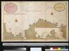
Een gedeelte van de kust van Barbarija beginnende van P. Soliman tot C. Mezurata
Libya Gerard van Keulen
Europe 1:1.000.000
1 : 1000000 Kréta (Řecko) Geographical Section, General Staff
Feuille No. 7, uit: Carte de la Turquie d'Asie (moins l'Arabie) / dessiné et héliogravé au Service géographique de l'Armée
1 : 1000000 titelvariant: Turquie d'Asie; Annotatie: Titel boven de kaart: Turquie d'Asie; Bl. genummerd 1-4 en 7-10; Met lijst van de meest gebruikte woorden op de kaart vertaald uit het Turks, Arabisch en Perzisch; Annotatie geografische gegevens: Inzetkrt. op bl. 9: Plan de Jérusalem et de ses environs, Plan d'Alep, Plan de Damas et de ses faubourgs, Plan de Beyrout et de ses environs (alle 1:50.000) Service géographique de l'Armée [S.l. : Service géographique de l'Armée]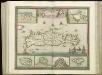
[83][83] Insula Candia ..., uit: Atlas sive Descriptio terrarum orbis
Annotatie: Gedigitaliseerde versie. Amsterdam. Heiloo : Picturae (vervaardiger), 2015. tiff-bestand. Gedigitaliseerd: 07-01-2015; Origineel: Universiteitsbibliotheek Vrije Universiteit (XL.05127.-) ; Netherlands; Titelpagina ontbreekt Wit, Frederik de Amsterdam : Frederick de Wit
Candia olim Creta
1 : 3830000 Kréta (Řecko)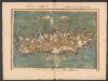
Tabula Neoterica Crete Sive Candie Insule [Karte], in: Claudii Ptolemei viri Alexandrini mathematice discipline philosophi doctissimi geographie opus [...], S. 281.
1 Karte aus Atlas Waldseemüller, Martin [und Ptolemaeus, Claudius] Übelin, Georg
Tripoli.
1 : 2000000 Society for the Diffusion of Useful Knowledge (Great Britain)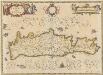
Candia olim Creta. [Karte], in: Novus atlas absolutissimus, Bd. 5, S. 294.
1 Karte aus Atlas Janssonius Offizin
CANDIA, | olim | CRETA
[Amsterdam : Joan Blaeu]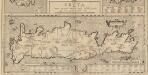
Creta Iovis magni, medio iacet insula ponto. [Karte], in: Theatrum orbis terrarum, S. 520.
1 Karte aus Atlas Ortelius, Abraham Vrients, Jan Baptista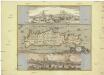
Insula Candia olim Creta
Kréta (Řecko) Weiland, Karl Ferdinand Visscher, Nicolaus N. Visscher
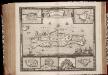
Insula Candia ejusque fortificatio / edita per F. de Wit
1 : 475000 Annotatie: Rechtsboven: 23; Origineel is Blad 173 in atlas factice; Annotatie geografische gegevens: Schaalstok: 15 Milliaria Germanica communia; Inzetkaarten van: Canea, Candia, Spina Longa, Retimo, Thine, Suda Frederick de Wit 1630-1706 Amsterdam : Gedruckt by Frederick de Wit inde Kalverstraet inde Witte Paskaert
Candia cum Insulis aliquot circa Graeciam[:] [Zypern] [Karte], in: Gerardi Mercatoris et I. Hondii Newer Atlas, oder, Grosses Weltbuch, Bd. 2, S. 336.
1 Karte aus Atlas Mercator, Gerhard und Hondius, Jodocus Jansson, Jan
Candia, olim Creta. [Karte], in: Le théâtre du monde, ou, Nouvel atlas contenant les chartes et descriptions de tous les païs de la terre, Bd. 3, S. 309.
1 Karte aus Atlas Blaeu, Willem Janszoon und Blaeu, Joan Blaeu, Willem Janszoon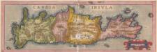
Candia Insula. [Karte], in: Theatrum orbis terrarum, S. 246.
1 Karte aus Atlas Ortelius, Abraham
INSULA | CANDIA | olim | CRETA.
N. Visscher exc.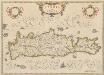
Candia, olim Creta. [Karte], in: Theatrum orbis terrarum, sive, Atlas novus, Bd. 3, S. 297.
1 Karte aus Atlas Blaeu, Joan Blaeu, Willem Janszoon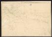
Candia cum Insulis aliquot circa Graeciam[:] [Zypern] [Karte], in: Gerardi Mercatoris Atlas, sive, Cosmographicae meditationes de fabrica mundi et fabricati figura, S. 493.
1 Karte aus Atlas Mercator, Gerhard Montanus, Petrus
Isle et royaume de Candie
1 : 810000 Kréta (Řecko) Sanson, Nicolas Cordier, Louis Pierre Mariette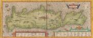
Creta Iovis magni, medio iacet insula ponto. [Karte], in: Theatrum orbis terrarum, S. 416.
1 Karte aus Atlas Ortelius, Abraham