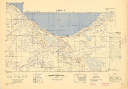
Maps of El Agheila
Egypt and Cyrenaica 1:250,000, Agheila
Egypt and Cyrenaica 1:250,000 , Series GSGS 4386. Great Britain. Army. Middle East Command. [London] : War Office
Tripoli.
1 : 2000000 Society for the Diffusion of Useful Knowledge (Great Britain)
Eastern Libya, Aerodrome Map
Aerodrome map of Eastern Libya, DR 326. Great Britain. Army. Royal Engineers. Field Survey Company, 512th. [Cairo] : [Survey Directorate, Middle East]
Feuille 46 (D VII), uit: Carte géologique internationale de l'Europe : la carte, votée au congrès géologique international de Bologne en 1881, est exécutée conformément aux décisions d'une commission internationale, avec le concours des gouvernements, sous le dir. de M.M. Beyrich et Hauchecorne
Annotatie: Blad 48 gamme des couleurs; blad 49: bladwijzer en titelblad Heinrich Ernst Beyrich 1815-1896; Wi. Hauchecorne Berlin : Reimer / (Berlin: Institut lithographique)
Africa 1:2.000.000, Cyrenaica
Cyrenaica, Libya
[XXIII], uit: Geognostische Karte des Oesterreichischen Kaiserstaates mit einem grossen Theile Deutschland's u. Italien / hauptsachlich nach ... Haidinger's geognostischer Karte dieses Staates bearb. von Josef Scheda
1 : 3000000 titelvariant: General-Karte von Europa in 25 Blättern; Annotatie: Bijlage bij: General-Karte von Europa in 25 Blättern. - 1:2.592.000. - 1845-1847 Scheda, Joseph Wien : K.K. Militär. Geografisch. Institut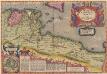
Africae Propriae Tabula, In qua, Punica regna vides; Tyrios, et Agenoris urbem. [Karte], in: Theatrum orbis terrarum, S. 439.
1 Karte aus Atlas Ortelius, Abraham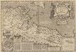
Africae Propriae Tabula, In qua, Punica regna vides; Tyrios, et Agenoris urbem. [Karte], in: Theatrum orbis terrarum, S. 523.
1 Karte aus Atlas Ortelius, Abraham Vrients, Jan Baptista
Schul-Atlas für die alte Erdbeschreibung : zur allgemeinen Schul-encyclopädie gehörig
J. H. Campe Zusammensetzung und Zeichnung von [...] Dufour, unter Leitung von Heusinger ; gestochen von Frentzel. Braunschweig : Schulbuchhandlung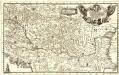
Eigentliche Vorstellung des so berühmten König: Reichs Ungarn neben Sibenbürgen, Moldau, Wallachey, Posnien und andern Ländern mehr bis an Constantinopel
1 : 1900000 Mollova mapová sbírka
Ancient Africa or Libya II.
1 : 5100000 Society for the Diffusion of Useful Knowledge (Great Britain)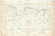
Tripoli & Egypt
1 : 3000000 Egypt E. Stanford
Sev. Afrika

Africa propria degli antichi, Numidia, Mauritania cesariense
1 : 6000000 [Marzolla, B.] [Verlag nicht ermittelbar]
Tunis et Tripoli
Nouvel atlas physique politique et historique de l'Empire ottoman et des états limitrophes en Europe, en Asie et en Afrique, en quarante feuilles Hellert, J.J. Bellizard, Dufour et Cie
[Carthago; Pasitigris, Babylonia, Susiana; Africa Propria, Mauretania, Numidia]
Schul-Atlas der alten Welt bei Justus Perthes
Lybia (Tripolitania y Cyenaica)
Libya (Tripolitania and Cyenaica), ADI (Maps) AM 180. [S.l.] : Air Ministry, United Kingdom, [19--]
Travels of St. Paul. Lower Egypt
1 : 8400000 Hughes, William
Karte der Nordküste Afrika's
Afrika severní Voss, C. L. Reimer
Carta plana desde Cartag.na á Constantinopla, con los derroteros de la esquadra Espanola en 1784, y 85
Středozemní moře-oblast Arnal, P. Bausa, F.
Südosteuropa um 800
Südosteuropa Zwick, J.
Universitätsbildungen im Spätmittelalter
Südosteuropa, Universitätsgründung Zwick, J.
Südosteuropa um 900
Südosteuropa, Byzantinisches Reich Zwick, J.
Südosteuropa in der Spätantike (Mitte des 4. Jh.)
Südosteuropa Spätantike Zwick, J.
Südosteuropa unter Kaiser Septimius Severus (193-211)
Südosteuropa Septimius Severus, Römisches Reich, Kaiser Zwick, J.
Südosteuropa um 1200
Südosteuropa, Byzantinisches Reich Zwick, J.
Südosteuropa um 1000
Südosteuropa, Byzantinisches Reich Zwick, J.
Secunda Affrice Tabula [Karte], in: [Clavdii Ptholomei Cosmographi ...], S. 290.
1 Karte aus Atlas Nicolaus Germanus [und Ptolemaeus, Claudius]
Lateinisches Kaiserreich 1204/1261
Südosteuropa, Lateinisches Kaiserreich Zwick, J.