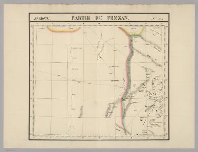
Maps of Ash Shati'

Partie du Fezzan. Afrique 9.
1 : 1641836 Vandermaelen, Philippe, 1795-1869
Aegypten.
1 : 3000000 Radefeld, Carl Christian Franz, 1788-1874
Neue Charte der Canarien Inseln
Kanárské ostrovy Linschoten, Jan Huygen van Bory de Saint-Vincent, Jean-Baptist Genevieve Marcellin
Africa 1:2.000.000, Fezzan
Fezzan, Libya
Western Libya, Aerodrome Map
Aerodrome map of Western Libya, DR 326. Great Britain. Army. Royal Engineers. Field Survey Company, 512th. [Cairo] : [Survey Directorate, Middle East]
Marocco, Algier und Tunis
Maroko Radefeld Kleinknecht
Charte von der Insel Teneriffa
Tenerife (Kanárské ostrovy) Homann, Johann Christoph Bory de Saint-Vincent, Jean-Baptist Genevieve Marcellin
Carte de la Régence de Tripoli et des principales routes commerciales de l'interieur de l'Afrique : d'après les observations de Mr. Prax, les renseignements recueillis par ce voyageur et les études faites par Mr. Renou
1 : 2000000 dressée par MM. Prax et Renou d'après les observations de Mr. Prax, les renseignements recueillis par ce voyageur, et les études faites par Mr. Renou gravée sur pierre par F. Delamare Paris : Lemercier
An accurate map of west Barbary, including Suse & Tafilelt, forming the dominions of the present emperor of Marocco
Maroko Jackson, James Grey Neele, Samuel John G. & W. Nicoll
Lybia (Tripolitania y Cyenaica)
Libya (Tripolitania and Cyenaica), ADI (Maps) AM 180. [S.l.] : Air Ministry, United Kingdom, [19--]
Karte der Nordküste Afrika's
Afrika severní Voss, C. L. Reimer
Spezial-Karte von Afrika
1 : 4000000 Blatt 2 Habenicht, Hermann Perthes
113-14. Libia.
1 : 5000000 Touring club italiano
Algérie
1 : 7000000 Alžírsko SCGGA
Spezial - karte von AfricaSektion Central-Sahara (2)
1 : 4000000 1 full d'1 mapa en 10 fulls i estoig Hermann Habenicht; Justus Perthes
Tabula Secunda Africae [Karte], in: Claudii Ptolemei viri Alexandrini mathematice discipline philosophi doctissimi geographie opus [...], S. 184.
1 Karte aus Atlas Waldseemüller, Martin [und Ptolemaeus, Claudius] Übelin, Georg
Africa Northern.
1 : 6400000 Hall, S. (Sidney)
Etats du roi de Maroc, les royaumes d'Alger, de Tunis et de Tripoli, avec les pays circonvoisins
1 : 9600000 Alžírsko Bonne, Rigobert André
Libyae, vel Africae pars borealis.
1 : 25000000 Fenner, Rest.
Mauritania, Africa propria, Cyrenaica
1 : 330000 Afrika severní Reichard, Christian Gottlieb Campius, D. a D. Campio
Bullettino decadico dell'osservatorio ed archivio centrale geodinamico
1 : 1200000 1885/28, Blatt 1 Archivio Centrale Geodinamico
Bullettino decadico dell'osservatorio ed archivio centrale geodinamico
1 : 1200000 1885/30, Blatt 2 Archivio Centrale Geodinamico
Bullettino decadico dell'osservatorio ed archivio centrale geodinamico
1 : 1200000 1885/5, Blatt 1 Archivio Centrale Geodinamico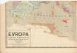
Evropa raného středověku: do konce VI. století po Kr.
Kašpar, Jan
[Secunda Affrice tabula] [Karte], in: Clavdii Ptholomei Viri Alexandrini Cosmographie, S. 161.
1 Karte aus Atlas Nicolaus Germanus [und Ptolemaeus, Claudius]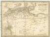
Berberei enthält das Reich Fez und Marocco, Algier, Tunis u. Tripoli
1 : 4500000 Afrika severní Biller, B. Tranquillo Mollo
Nord-Africa Berberei
1 : 9678000 Afrika severní Schlieben Gleditsch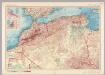
Morocco, Algeria, Tunisia. Pergamon World Atlas.
1 : 5000000 Polish Army Topography Service
In notitiam ecclesiasticam Africae tabula geographica
1 : 4500000 L'Isle, Guillaume de, 1675-1726 Apud Auctorem, Via vulgo dicta des Canettes propè Sancti Sulpitii fanum