Maps of Mediterranean Sea

[Secunda Affrice tabula] [Karte], in: Clavdii Ptholomei Viri Alexandrini Cosmographie, S. 161.
1 Karte aus Atlas Nicolaus Germanus [und Ptolemaeus, Claudius]
Aphricae Tabula II. [Karte], in: Geographia universalis vetus et nova complectens Claudii Ptolemaei Alexandrini enarrationis libros VIII, S. 257.
1 Karte aus Atlas Münster, Sebastian [und Ptolemaeus, Claudius]
Tabula Secunda Africae [Karte], in: Claudii Ptolemei viri Alexandrini mathematice discipline philosophi doctissimi geographie opus [...], S. 184.
1 Karte aus Atlas Waldseemüller, Martin [und Ptolemaeus, Claudius] Übelin, Georg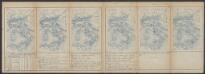
Aphricae Tabula II. [Karte], in: Claud. Ptolemaeus. Geographia lat. cum mappis [...], S. 287.
1 Karte aus Atlas Münster, Sebastian [und Ptolemaeus, Claudius]
Afrique Septentrionale.
1 : 8000000 Montemont, A.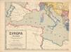
Evropa XIX. století: od vídeňského kongresu r. 1815, do rozhodnutí na frontách světové války r. 1918
Kašpar, Jan
Karte des Mittelländischen Meeres
Středozemní moře-oblast Handtke, Friedrich C. Flemming
Secunda Affrice Tabula [Karte], in: [Clavdii Ptholomei Cosmographi ...], S. 290.
1 Karte aus Atlas Nicolaus Germanus [und Ptolemaeus, Claudius]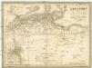
Berberei enthält das Reich Fez und Marocco, Algier, Tunis u. Tripoli
1 : 4500000 Afrika severní Biller, B. Tranquillo Mollo
Africae tabula geographica.
1 : 5700000 L'Isle, Guillaume de, 1675-1726
In notitiam ecclesiasticam Africae tabula geographica
1 : 4500000 L'Isle, Guillaume de, 1675-1726 Apud Auctorem, Via vulgo dicta des Canettes propè Sancti Sulpitii fanum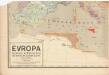
Evropa raného středověku: do konce VI. století po Kr.
Kašpar, Jan
Occidentalior tractus Maris Mediterranei
1 Karte : Kupferdruck ; 47 x 56 cm Renard apud L. Renard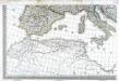
Carte d'Europe ou sont tracées les limites des empires, royaumes, et etats souverains, feuille 5
1 Blatt : 56 x 87 cm Semen etc
Tabula Prima Africae. [Karte], in: Claudii Ptolemei viri Alexandrini mathematice discipline philosophi doctissimi geographie opus [...], S. 181.
1 Karte aus Atlas Waldseemüller, Martin [und Ptolemaeus, Claudius] Übelin, Georg
In notitiam ecclesiasticam Africæ tabula geographica
1 : 5700000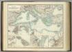
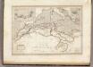
Mediterranean Basin.
1 : 6800000 Johnston, Alexander Keith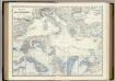
Mediterranean Basin.
1 : 6400000 Johnston, Alexander Keith, 1804-1871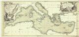
Carte de la mer Mediterranée
Středozemní moře Bonne, Rigobert Bourbon, Louis Alexandre de chez Lattré
Carte generale de toute l'Europe, 5
1 Blatt : 56 x 46 cm J.M. Will
[133][136] Occidentalior tractus Maris Mediterranei, uit: Atlas sive Descriptio terrarum orbis
Annotatie: Gedigitaliseerde versie. Amsterdam. Heiloo : Picturae (vervaardiger), 2015. tiff-bestand. Gedigitaliseerd: 07-01-2015; Origineel: Universiteitsbibliotheek Vrije Universiteit (XL.05127.-) ; Netherlands; Titelpagina ontbreekt Wit, Frederik de Amsterdam : Frederick de Wit
North Africa or Barbary : Marocco
1 : 2800000 Society for the Diffusion of Useful Knowledge (Great Britain) George Cox
North Africa or Barbary : Tripoli
1 : 2000000 Society for the Diffusion of Useful Knowledge (Great Britain) George Cox
North Africa or Barbary : Algier
1 : 2000000 Society for the Diffusion of Useful Knowledge (Great Britain) George Cox
North Africa or Barbary : Parts of Tripoli and Egypt
1 : 2000000 Society for the Diffusion of Useful Knowledge (Great Britain) George Cox
North Africa or Barbary : Tunis and part of Tripoli
1 : 2000000 Society for the Diffusion of Useful Knowledge (Great Britain) George Cox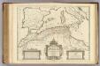
Africae Tabula Geographica.
1 : 4500000 L'Isle, Guillaume de, 1675-1726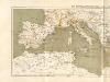
Atlas für Industrie- und Handelsgeographie: Für commercielle und technische Lehranstalten, für Kaufleute und Industrielle

![[Secunda Affrice tabula] [Karte], in: Clavdii Ptholomei Viri Alexandrini Cosmographie, S. 161.](https://images-2.georeferencer.com/images/iiif/479889727525/full/,300/0/native.jpg)

