Maps of Mediterranean Sea

Secunda Affrice Tabula [Karte], in: [Clavdii Ptholomei Cosmographi ...], S. 290.
1 Karte aus Atlas Nicolaus Germanus [und Ptolemaeus, Claudius]
Aphricae Tabula II. [Karte], in: Geographia universalis vetus et nova complectens Claudii Ptolemaei Alexandrini enarrationis libros VIII, S. 257.
1 Karte aus Atlas Münster, Sebastian [und Ptolemaeus, Claudius]
[Secunda Affrice tabula] [Karte], in: Clavdii Ptholomei Viri Alexandrini Cosmographie, S. 161.
1 Karte aus Atlas Nicolaus Germanus [und Ptolemaeus, Claudius]
Tabula Secunda Africae [Karte], in: Claudii Ptolemei viri Alexandrini mathematice discipline philosophi doctissimi geographie opus [...], S. 184.
1 Karte aus Atlas Waldseemüller, Martin [und Ptolemaeus, Claudius] Übelin, Georg
Aphricae Tabula II. [Karte], in: Claud. Ptolemaeus. Geographia lat. cum mappis [...], S. 287.
1 Karte aus Atlas Münster, Sebastian [und Ptolemaeus, Claudius]
Carta plana desde Cartag.na á Constantinopla, con los derroteros de la esquadra Espanola en 1784, y 85
Středozemní moře-oblast Arnal, P. Bausa, F.
North Africa or Barbary : Marocco
1 : 2800000 Society for the Diffusion of Useful Knowledge (Great Britain) George Cox
North Africa or Barbary : Tripoli
1 : 2000000 Society for the Diffusion of Useful Knowledge (Great Britain) George Cox
North Africa or Barbary : Algier
1 : 2000000 Society for the Diffusion of Useful Knowledge (Great Britain) George Cox
North Africa or Barbary : Parts of Tripoli and Egypt
1 : 2000000 Society for the Diffusion of Useful Knowledge (Great Britain) George Cox
North Africa or Barbary : Tunis and part of Tripoli
1 : 2000000 Society for the Diffusion of Useful Knowledge (Great Britain) George Cox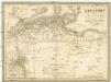
Berberei enthält das Reich Fez und Marocco, Algier, Tunis u. Tripoli
1 : 4500000 Afrika severní Biller, B. Tranquillo Mollo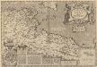
Africae Propriae Tabula, In qua, Punica regna vides; Tyrios, et Agenoris urbem. [Karte], in: Theatrum orbis terrarum, S. 523.
1 Karte aus Atlas Ortelius, Abraham Vrients, Jan Baptista
Schul-Atlas für die alte Erdbeschreibung : zur allgemeinen Schul-encyclopädie gehörig
J. H. Campe Zusammensetzung und Zeichnung von [...] Dufour, unter Leitung von Heusinger ; gestochen von Frentzel. Braunschweig : Schulbuchhandlung
Africae tabula geographica.
1 : 5700000 L'Isle, Guillaume de, 1675-1726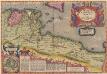
Africae Propriae Tabula, In qua, Punica regna vides; Tyrios, et Agenoris urbem. [Karte], in: Theatrum orbis terrarum, S. 439.
1 Karte aus Atlas Ortelius, Abraham
In notitiam ecclesiasticam Africæ tabula geographica
1 : 5700000
Africa propria degli antichi, Numidia, Mauritania cesariense
1 : 6000000 [Marzolla, B.] [Verlag nicht ermittelbar]
Occidentalior tractus Maris Mediterranei
1 Karte : Kupferdruck ; 47 x 56 cm Renard apud L. Renard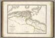
Afrique Propre.
1 : 3800000 Lapie, M. (Pierre), 1779-1850
Bullettino decadico dell'osservatorio ed archivio centrale geodinamico
1 : 1200000 1885/30, Blatt 2 Archivio Centrale Geodinamico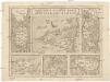
Insvlarum aliquot Maris Mediterranei descriptio
Elba (Itálie) Ortelius, Abraham Gastaldi, Giacomo Abraham Ortelius
Italien
1 : 5000000 1 Karte Top. Anstalt v. J. Wurster, Winterthur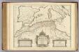
Africae Tabula Geographica.
1 : 4500000 L'Isle, Guillaume de, 1675-1726
Tunis et Tripoli
Nouvel atlas physique politique et historique de l'Empire ottoman et des états limitrophes en Europe, en Asie et en Afrique, en quarante feuilles Hellert, J.J. Bellizard, Dufour et Cie
Bullettino decadico dell'osservatorio ed archivio centrale geodinamico
1 : 1200000 1885/28, Blatt 1 Archivio Centrale Geodinamico
Paskaert van 't westelycke deel der Middelandsche Zee
1 Karte : Kupferdruck ; 41 x 51 cm Doncker by Hendrick Doncker boekverkoper en graadbooghmaker inde Nieuwbrugsteegh in 't Stuurmans gereedschap
Bullettino decadico dell'osservatorio ed archivio centrale geodinamico
1 : 1200000 1885/5, Blatt 1 Archivio Centrale Geodinamico

![Secunda Affrice Tabula [Karte], in: [Clavdii Ptholomei Cosmographi ...], S. 290.](https://images-2.georeferencer.com/images/iiif/869838317984/full/,300/0/native.jpg)

