Maps of Mediterranean Sea
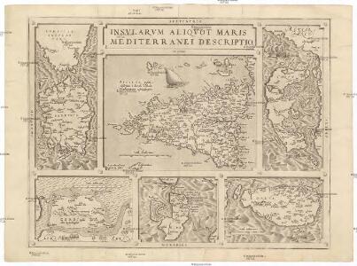
Insvlarum aliquot Maris Mediterranei descriptio
Elba (Itálie) Ortelius, Abraham Gastaldi, Giacomo Abraham Ortelius
Italien
1 : 5000000 1 Karte Top. Anstalt v. J. Wurster, Winterthur
Carte des états de la république de Venise
Benátky (Itálie)
Carte reduite de la Mer Mediterranée, 2
1 Blatt : 59 x 51 cm ; s.n.
Carta plana desde Cartag.na á Constantinopla, con los derroteros de la esquadra Espanola en 1784, y 85
Středozemní moře-oblast Arnal, P. Bausa, F.
Secunda Affrice Tabula [Karte], in: [Clavdii Ptholomei Cosmographi ...], S. 290.
1 Karte aus Atlas Nicolaus Germanus [und Ptolemaeus, Claudius]
Grece et ses Colonies.
Andriveau-Goujon, J.
Classical lands of the Mediterranean
1 : 2217600 Athény (starověký řecký stát) National Geographic Society
Südosteuropa um 500
Südosteuropa Zwick, J.
Poloostrov Apenninský a Balkánský
1 : 5000000 Apeninský poloostrov Státní nakladatelství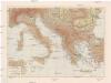
Poloostrov Apenninský a Balkánský
1 : 5000000 Apeninský poloostrov Státní nakladatelství
Südosteuropa nach den Balkankriegen
Südosteuropa Balkankrieg <1912-1913> Zwick, J. ; Clewing, K.
Tabula Moderna Bossine, Servie, Gretiae Et Sclavonie [Karte], in: Claudii Ptolemei viri Alexandrini mathematice discipline philosophi doctissimi geographie opus [...], S. 260.
1 Karte aus Atlas Waldseemüller, Martin [und Ptolemaeus, Claudius] Übelin, Georg
Empire Grec et Royaume d'Italie 774 a 900.
1 : 6600000 Houze, Antoine Philippe
La Grece au temps de Philippe et d'Alexandre, l'Italie, 400 a 300 av. J.C.
1 : 6600000 Houze, Antoine Philippe
Italien und die Balkanhalbinsel
1 : 6000000 Balkanhalbinsel, Italien
Südosteuropa vor den Balkankriegen
Südosteuropa Balkankrieg <1912-1913> Zwick, J. ; Clewing, K.
La Turquie, la Grece et l'Italie de 1700 a 1840.
1 : 6600000 Houze, Antoine Philippe
La Grece et l'Italie, 306 a 410, ap. J.C.
1 : 6600000 Houze, Antoine Philippe
[Südosteuropa und Italien]
Evropa jihovýchodní
Südeuropa
1 : 1500000 Evropa jižní Justus Perthes
Südeuropa
1 : 1500000 Evropa jižní Justus Perthes
L'Empire Grec, l'Italie, 1002 a 1125.
1 : 6600000 Houze, Antoine Philippe
La Grece, l'Italie, 1190 a 504 av. J.C.
1 : 6600000 Houze, Antoine Philippe
L'Empire Ottoman, l'Italie, 1400 a 1500.
1 : 6600000 Houze, Antoine Philippe
L'Empire Grec, l'Italie, 1300 a 1400.
1 : 6600000 Houze, Antoine Philippe
L'Empire Ottoman, la Grece et l'Italie de 1500 a 1700.
1 : 6600000 Houze, Antoine Philippe
L'Empire Romain d'Orient, Royaume des Lombards 553 a 774.
1 : 6600000 Houze, Antoine Philippe
L'Empire Grec, l'Italie, 900 a 1002.
1 : 6600000 Houze, Antoine Philippe