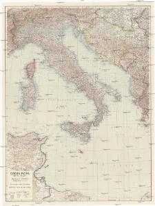
Maps of Italy

Südeuropa
1 : 1500000 Evropa jižní Justus Perthes
Südeuropa
1 : 1500000 Evropa jižní Justus Perthes
Italie
1 : 2600000 A. Taride Paris : A.Taride
Italien
Schul-Atlas in 36 Karten Völter, Daniel Verlag der J.M. Dannheimer'schen Buchhandlung
Carte polychrome de l'Italie antique et moderne / par Pierre Tardieu et Audot père
Pierre Tardieu Audot, père et fils

Map of Italy.
1 : 6050000 Bowen, Emanuel

Kaart van Italië c.a.
1 : 3500000 titelvariant: Italië; Annotatie: Titel rechtsonder: Italië [S.l. : s.n.]
Italien 1865
Italien Kunz, Andreas ; Moeschl, Joachim Robert
Italien 1861
Italien Kunz, Andreas ; Moeschl, Joachim Robert
Italien 1871
Italien Kunz, Andreas ; Moeschl, Joachim Robert
Carta geografica statistica e postale dell'Italia
From Whole
Italien 1870
Italien Kunz, Andreas ; Moeschl, Joachim Robert
Italien 1829
Italien Kunz, Andreas ; Moeschl, Joachim Robert
Italien März 1799
Italien Kunz, Andreas ; Treiling, Thomas ; Moeschl, Joachim
Italien 1866
Italien Kunz, Andreas ; Moeschl, Joachim Robert
Bullettino decadico dell'osservatorio ed archivio centrale geodinamico
1 : 1200000 1886/8, Blatt 2 Archivio Centrale Geodinamico
Homannův atlas světa
1 : 2100000
Italien
Handatlas über alle Theile der Erde und über das Weltgebäude Stieler, Adolf Justus Perthes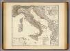
Italia, Gallia citerior, Illyricum, Sicilia, Sardinia, Corsica.
1 : 3900000 Menke, Th.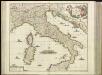
[27][27]Novissima et accuratissima totius Italiae, Corsicae et Sardiniae descriptio, uit: Atlas sive Descriptio terrarum orbis
Annotatie: Gedigitaliseerde versie. Amsterdam. Heiloo : Picturae (vervaardiger), 2015. tiff-bestand. Gedigitaliseerd: 07-01-2015; Origineel: Universiteitsbibliotheek Vrije Universiteit (XL.05127.-) ; Netherlands; Titelpagina ontbreekt Wit, Frederik de Amsterdam : Frederick de Wit
Italien Oktober 1797
Italien Kunz, Andreas ; Treiling, Thomas ; Moeschl, Joachim
Italien 1820
Italien Kunz, Andreas ; Moeschl, Joachim Robert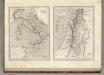
Italie Ancienne, Palestine ou Terre Sainte Ancienne.
1 : 48000001080000 Montemont, A.
Bullettino decadico dell'osservatorio ed archivio centrale geodinamico
1 : 1200000 1886/31, Blatt 2 Archivio Centrale Geodinamico
Italien 1804
Italien Kunz, Andreas ; Treiling, Thomas ; Moeschl, Joachim
Italien
Hand-Atlas über alle Theile der Erde und über das Weltgebäude Stieler, Adolf Justus Perthes
Italien 1809
Italien Kunz, Andreas ; Treiling, Thomas ; Moeschl, Joachim