Maps of Illizi

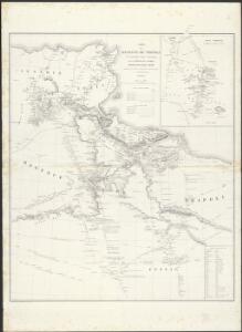
Carte de la Régence de Tripoli et des principales routes commerciales de l'interieur de l'Afrique : d'après les observations de Mr. Prax, les renseignements recueillis par ce voyageur et les études faites par Mr. Renou
1 : 2000000 dressée par MM. Prax et Renou d'après les observations de Mr. Prax, les renseignements recueillis par ce voyageur, et les études faites par Mr. Renou gravée sur pierre par F. Delamare Paris : Lemercier
An accurate map of west Barbary, including Suse & Tafilelt, forming the dominions of the present emperor of Marocco
Maroko Jackson, James Grey Neele, Samuel John G. & W. Nicoll
Karte von Fes und Marócos
Afrika severní Bruns, Paul Jakob Anville, Jean-Baptiste Bourguinon d' Weigel- und Schneiderschen Handlung
Africa 1:2.000.000, Tunisie
Tripolitania, Libya (also Tunisia)
Schul-Atlas für die alte Erdbeschreibung : zur allgemeinen Schul-encyclopädie gehörig
J. H. Campe Zusammensetzung und Zeichnung von [...] Dufour, unter Leitung von Heusinger ; gestochen von Frentzel. Braunschweig : Schulbuchhandlung
Africae Propriae Tabula, In qua, Punica regna vides; Tyrios, et Agenoris urbem. [Karte], in: Theatrum orbis terrarum, S. 439.
1 Karte aus Atlas Ortelius, Abraham
Africae Propriae Tabula, In qua, Punica regna vides; Tyrios, et Agenoris urbem. [Karte], in: Theatrum orbis terrarum, S. 523.
1 Karte aus Atlas Ortelius, Abraham Vrients, Jan Baptista
Feuille 45 (C VII), uit: Carte géologique internationale de l'Europe : la carte, votée au congrès géologique international de Bologne en 1881, est exécutée conformément aux décisions d'une commission internationale, avec le concours des gouvernements, sous le dir. de M.M. Beyrich et Hauchecorne
Annotatie: Blad 48 gamme des couleurs; blad 49: bladwijzer en titelblad Heinrich Ernst Beyrich 1815-1896; Wi. Hauchecorne Berlin : Reimer / (Berlin: Institut lithographique)
Afrika

Charte du Royaume d'Alger
1 : 3800000 Alžírsko Weiland, Karl Ferdinand Kaiser, F.
Stato di Tunisi.
1 : 2000000 Marzolla, Benedetto
Aegypten.
1 : 3000000 Radefeld, Carl Christian Franz, 1788-1874
Carte générale de l'Algérie à l'échelle de 1 m. pour 1,600,000 m
1 : 1600000 Ostblatt Duveyrier, Henri Dépôt de la Guerre
[Maroko]
Maroko Zeithammer, Antonín Otakar Badía y Leblich, Domingo
Algerien (Algerie)
1 : 2450000 Ziegler, J. M.
Algerie, Tunisie.
1 : 2500000 Vivien St Martin, L.
Western Libya, Aerodrome Map
Aerodrome map of Western Libya, DR 326. Great Britain. Army. Royal Engineers. Field Survey Company, 512th. [Cairo] : [Survey Directorate, Middle East]
Partie du Fezzan. Afrique 9.
1 : 1641836 Vandermaelen, Philippe, 1795-1869
Partie, Tunis et Tripoli. Afrique 3.
1 : 1641836 Vandermaelen, Philippe, 1795-1869
Tunis, Tripoli.
1 : 2000000 Society for the Diffusion of Useful Knowledge (Great Britain)
Map of the Kingdom of Marocco
Maroko Zeithammer, Antonín Otakar Badía y Leblich, Domingo
Tunis u. westl. Theil von Tripoli
1 : 2000000 Libye C. Flemming
Neueste Karte von Tunis
Grosser Hand-Atlas über alle Theile der Erde in 170 Karten Meyer, J. Verlag des Bibliographischen Instituts
Tunis.
1 : 2000000 Radefeld, Carl Christian Franz, 1788-1874
Carte De La Mer Mediterranee. VI.
Roux, Joseph
Tunis, Tripoli.
1 : 2000000 Flemming, Carl
Marocco
Maroko Zeithammer, Antonín Otakar Washington
Dépt. De Constantine carte politique
Vidal de La Blache, Paul
Carte routière de la Tunisie au 1er juillet 1905
1 : 500000 Tunisie. Direction générale des travaux publics Paris : Erhard