Maps of Appalachian Mountains

Map of the United States exhibiting the post-roads, the situations, connections & distances of the post-offices, stage roads, counties, ports of entry and delivery for foreign vessels, and the principal rivers
United States of America

United States.
1 : 10400000 Lucas, Fielding Jr.
Chapin's Ornamental Map Of The United States.
1 : 2150000 Chapin, William
United States of America.
1 : 5950000 Thomson, John
Verein-Staaten von Nord-America mit Ausnahme Florida's und der westlichen Territoirien
Hand-Atlas über alle Theile der Erde und über das Weltgebäude Stieler, Adolf Justus Perthes
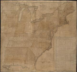
The United States of America confirmed by treaty 1783

A Map Of The Roads, Canals And Steam Boat Routes Of The United States
1 : 4118400 Tanner, Henry S.
Map of the United States.
1 : 6750000 Scott, Joseph
Map of the United States of America.
1 : 5800000 Melish, John
United States.
1 : 6000000 Colton, J. H.
States of America, drawn from the best authorities

Etats Unis de l'Amérique
1 : 13000000 gravé par Tardieu corr. et augm. en 1803 [Paris] : [s.n.]
United States Of North America.
1 : 1550000 Arrowsmith, Aaron
United States of America - East. Pergamon World Atlas.
1 : 5000000 Polish Army Topography Service
Mitchell's map of the United States.
1 : 14752000 Mitchell, Samuel Augustus
Eastern United States.
1 : 4748000 Johnston, Alexander Keith
A New Map of the United States.
1 : 1520640 Carleton, Osgood
United States of Nth. America.
1 : 1584000 Tardieu, P.F.
United States

Verein-Staaten von Nord-America mit Ausnahme Florida's und der westlichen Territoirien
Hand-Atlas über alle Theile der Erde nach dem neuesten Zustande und über das Weltgebäude Stieler, Adolf bei Justus Perthes
Bacon's steel plate map of the American states north &south, showing the railways, forts, and fortifications

United States of Nth. America = Carte des Etats-unis de l'Amérique septentrionale / copiée et gravée sur celle d'Arrowsmith; corrigée et considérablement augmentée d'après les renseignemens les plus authentiques par P.F. Tardieu, graveur, editeur-propriétaire, Place de l'Estrapade, No. 18. à Paris, an XL 1802; ecrit par J.J. Pachoux; Chles. Picquet, géographe-graveur ...
from Parts P.F. Tardieu; J. J. Pachoux; Charles Picquet,
United States E.
1 : 4748000 Johnston, Alexander Keith, 1804-1871
An accurate map of the United States of America, with part of the surrounding provinces agreeable to the Treaty of Peace of 1783
1 : 1
United States.
1 : 8000000 Seaman, James V.
A diagram of the United States shewing the bearings and distances.
1 : 8350000 Melish, John
Mitchell's Reference & Distance Map Of The United States.
1 : 1584000 Young, James H.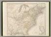
Etats-Unis d'Amerique.
1 : 4200000 Poussin, Guillaume Tell, 1794-1876