Maps of Appalachian Mountains

United States.
1 : 6000000 Colton, J. H.
United States Of North America.
1 : 1550000 Arrowsmith, Aaron
[Kaart], uit: Appleton's spoorwegkaart van de Vereenigde Staten en Canada / door G.F. Thomas ; engraved by Rae Smith
1 : 3550000 titelvariant: Spoorwegkaart van de Vereenigde Staten en Canada; Annotatie: Oorspr. uitg. 1871 uitg. door D. Appleton G.F. Thomas fl. 1872; Smith, Rae Amsterdam : J.H. Laarman
Mitchell's map of the United States.
1 : 14752000 Mitchell, Samuel Augustus
Chapin's Ornamental Map Of The United States.
1 : 2217600 Taylor, J.B.
New Map of the United States.
1 : 1584000 Young, James H.
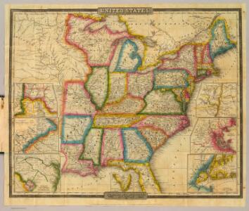
United States.
1 : 1500000 Smith, J. Calvin
United States.
1 : 8050000 Tanner, Henry S.
United States.
1 : 6200000 Hughes, William
Population - United States census, 1870. Density, Foreign, Colored, British American, Swedish and Norwegian.
1 : 15000000 Baskin, Forster and Company
Population - United States census, 1870. Density, Foreign, Colored, British American, Swedish and Norwegian.
1 : 14000000 Andreas, A. T. (Alfred Theodore), 1839-1900
Population, United States Census, 1870: Density, foreign, colored, British American, Swedish and Norwegian.
Andreas, A. T. (Alfred Theodore), 1839-1900
United States.
1 : 2471040 Munson, S. Bishop
Mitchell's Reference & Distance Map Of The United States.
1 : 1584000 Young, James H.
Chapin's Ornamental Map Of The United States.
1 : 2150000 Chapin, William
Karte der katholischen Diocesen und deren Missionen in Nordamerika nach den neuesten geographischen Angaben
1 : 22430000 Spojené státy americké-oblast východní Salzbacher, Joseph Engel, H. Joseph Salzbacher
Map of the United States Of North America.
1 : 1837440 Burr, David H., 1803-1875
Alden's Pictorial Map Of The United States Of North America.
1 : 2851200 Alden, Albert
US Population 1830, 1840.
1 : 10040000 Walker, Francis Amasa, 1840-1897
United States.
1 : 8000000 Tanner, Henry S.
United States.
1 : 8000000 Tanner, Henry S.
Verein-Staaten von Nord-America mit Ausnahme Florida's und der westlichen Territoirien
Hand-Atlas über alle Theile der Erde und über das Weltgebäude Stieler, Adolf Justus Perthes
Verein-Staaten von Nord-America mit Ausnahme Florida's und der westlichen Territoirien
Hand-Atlas über alle Theile der Erde nach dem neuesten Zustande und über das Weltgebäude Stieler, Adolf bei Justus Perthes
Mitchell's Reference & Distance Map Of The United States.
1 : 1584000 Young, James H.
United States Of North America.
1 : 1350000 Lewis, Samuel
United States Of North America.
1 : 1550000 Arrowsmith, Aaron
Etats-Unis d'Amerique.
1 : 4200000 Poussin, Guillaume Tell, 1794-1876
A diagram of the United States shewing the bearings and distances.
1 : 8350000 Melish, John
United States.
1 : 8000000 Mitchell, Samuel Augustus