Maps of Appalachian Mountains

Bacon's steel plate map of the American states north &south, showing the railways, forts, and fortifications

Map of the United States exhibiting the post-roads, the situations, connections & distances of the post-offices, stage roads, counties, ports of entry and delivery for foreign vessels, and the principal rivers

United States.
1 : 10400000 Lucas, Fielding Jr.
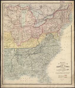
Map of the Atlantic States, showing distances from Washington (in bee line) by 50 mile circles
United States of America.
1 : 5950000 Thomson, John
United States E.
1 : 4748000 Johnston, Alexander Keith, 1804-1871
United States.
1 : 6000000 Colton, J. H.
Verein-Staaten von Nord-America mit Ausnahme Florida's und der westlichen Territoirien
Hand-Atlas über alle Theile der Erde nach dem neuesten Zustande und über das Weltgebäude Stieler, Adolf bei Justus Perthes
United States of America - East. Pergamon World Atlas.
1 : 5000000 Polish Army Topography Service
Mitchell's map of the United States.
1 : 14752000 Mitchell, Samuel Augustus
A diagram of the United States shewing the bearings and distances.
1 : 8350000 Melish, John
Etats-Unis d'Amerique.
1 : 4200000 Poussin, Guillaume Tell, 1794-1876
Chapin's Ornamental Map Of The United States.
1 : 2150000 Chapin, William
Eastern United States.
1 : 4748000 Johnston, Alexander Keith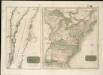
United States of America

Eastern United States.
1 : 4748000 Johnston, Alexander Keith
Etats Unis de l'Amérique
1 : 13000000 gravé par Tardieu corr. et augm. en 1803 [Paris] : [s.n.]
Map of the Atlantic States, Showing Distances From Washington (In BeeLine) By 50 Mile Circles.
1 : 8236800 Prang, L. & Co.
Verein-Staaten von Nord-America mit Ausnahme Florida's und der westlichen Territoirien
Hand-Atlas über alle Theile der Erde und über das Weltgebäude Stieler, Adolf Justus Perthes
United States Of North America.
1 : 1550000 Arrowsmith, Aaron
Chapin's Ornamental Map Of The United States.
1 : 2217600 Taylor, J.B.
United States Of North America.
1 : 1550000 Arrowsmith, Aaron
[Kaart], uit: Appleton's spoorwegkaart van de Vereenigde Staten en Canada / door G.F. Thomas ; engraved by Rae Smith
1 : 3550000 titelvariant: Spoorwegkaart van de Vereenigde Staten en Canada; Annotatie: Oorspr. uitg. 1871 uitg. door D. Appleton G.F. Thomas fl. 1872; Smith, Rae Amsterdam : J.H. Laarman
The United States of America confirmed by treaty 1783

United States Of North America.
1 : 1350000 Lewis, Samuel
A Map Of The Roads, Canals And Steam Boat Routes Of The United States
1 : 4118400 Tanner, Henry S.
United States.
1 : 8200000 Woodbridge, William C.
United States.
1 : 5000000 Arrowsmith, John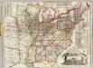
Watson's new rail-road and distance map of the United States and Canada.
1 : 2344320 Watson, Gaylord